Difference between revisions of "2015-11-08 49 11"
From Geohashing
imported>Klaus (template) |
imported>FippeBot m (Location) |
||
| (4 intermediate revisions by one other user not shown) | |||
| Line 1: | Line 1: | ||
| − | + | [[Image:{{{image|2015-11-08 49 11 field with geohash.jpg}}}|thumb|left]] | |
| − | |||
| − | |||
| − | |||
| − | |||
| − | |||
| − | |||
| − | |||
{{meetup graticule | {{meetup graticule | ||
| lat=49 | | lat=49 | ||
| Line 15: | Line 8: | ||
}} | }} | ||
| − | |||
__NOTOC__ | __NOTOC__ | ||
== Location == | == Location == | ||
| − | + | in a field between Hohenpölz und Brunn | |
== Participants == | == Participants == | ||
| − | + | * [[User:Klaus|Klaus]] and parts of his family | |
| − | |||
== Plans == | == Plans == | ||
| − | + | ||
| + | I'm visiting my parents and this geohash is very near to where they live. | ||
| + | Plan is to grab a bicycle, cycle there and cash the easy hash on Sunday, probably after noon at around 14:00. | ||
== Expedition == | == Expedition == | ||
| − | + | We did an afternoon walk and arrived at around 14:50 at the field where the geohash was. | |
| + | Luckily, the field was not too muddy, so I walked to the geohash while the rest of my family was staying on the track. | ||
== Tracklog == | == Tracklog == | ||
| − | + | none this time | |
== Photos == | == Photos == | ||
| − | |||
| − | |||
| − | |||
<gallery perrow="5"> | <gallery perrow="5"> | ||
| + | Image:2015-11-08 49 11 field with geohash.jpg | The field with the geohash | ||
| + | Image:2015-11-08 49 11 proof.jpg | Proof (quite blurry, but note the green distance) | ||
| + | Image:2015-11-08 49 11 view from geohash1.jpg | View from geohash 1 | ||
| + | Image:2015-11-08 49 11 view from geohash2.jpg | View from geohash 2 | ||
| + | Image:2015-11-08 49 11 view from geohash3.jpg | View from geohash 3 | ||
| + | Image:2015-11-08_49_11_view_hohenpoelz.jpg | nice view to Hohenpölz, around 100m from the geohash | ||
</gallery> | </gallery> | ||
== Achievements == | == Achievements == | ||
{{#vardefine:ribbonwidth|800px}} | {{#vardefine:ribbonwidth|800px}} | ||
| − | |||
| − | |||
| − | |||
| − | |||
| − | + | {{land geohash | |
| − | + | | latitude = 49 | |
| − | [[ | + | | longitude = 11 |
| − | + | | date = 2015-11-08 | |
| + | | name = [[User:Klaus|Klaus]] | ||
| + | }} | ||
| + | |||
| + | {{Walk geohash | ||
| + | | latitude = 49 | ||
| + | | longitude = 11 | ||
| + | | date = 2015-11-08 | ||
| + | | name = [[User:Klaus|Klaus]] | ||
| + | }} | ||
| + | |||
| + | {{Minesweeper geohash | ||
| + | | graticule = 48,11 | ||
| + | | ranknumber = 1 | ||
| + | | n = true | ||
| + | | name = Klaus | ||
| + | }} | ||
| + | |||
| + | {{Minesweeper geohash | ||
| + | | graticule = 49,11 | ||
| + | | ranknumber = 1 | ||
| + | | s = true | ||
| + | | name = Klaus | ||
| + | }} | ||
| − | |||
| − | |||
[[Category:Expeditions]] | [[Category:Expeditions]] | ||
| − | |||
[[Category:Expeditions with photos]] | [[Category:Expeditions with photos]] | ||
| − | |||
| − | |||
| − | |||
| − | |||
| − | |||
[[Category:Coordinates reached]] | [[Category:Coordinates reached]] | ||
| − | + | {{location|DE|BY|BA}} | |
| − | |||
| − | |||
| − | |||
| − | |||
| − | |||
| − | |||
| − | |||
| − | |||
| − | |||
| − | |||
| − | |||
| − | |||
| − | |||
| − | |||
| − | |||
| − | |||
| − | |||
Latest revision as of 05:44, 15 August 2019
| Sun 8 Nov 2015 in 49,11: 49.9053471, 11.1586973 geohashing.info google osm bing/os kml crox |
Location
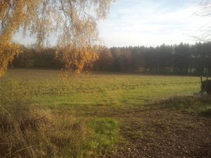
in a field between Hohenpölz und Brunn
Participants
- Klaus and parts of his family
Plans
I'm visiting my parents and this geohash is very near to where they live. Plan is to grab a bicycle, cycle there and cash the easy hash on Sunday, probably after noon at around 14:00.
Expedition
We did an afternoon walk and arrived at around 14:50 at the field where the geohash was. Luckily, the field was not too muddy, so I walked to the geohash while the rest of my family was staying on the track.
Tracklog
none this time
Photos
Achievements
Klaus earned the Land geohash achievement
|
Klaus earned the Walk geohash Achievement
|
Klaus achieved level 1 of the Minesweeper Geohash achievement
|
Klaus achieved level 1 of the Minesweeper Geohash achievement
|


