Difference between revisions of "2015-11-08 51 4"
imported>FelixTheCat |
imported>FippeBot m (Location) |
||
| (5 intermediate revisions by one other user not shown) | |||
| Line 4: | Line 4: | ||
| date=2015-11-08 | | date=2015-11-08 | ||
}} | }} | ||
| − | |||
__NOTOC__ | __NOTOC__ | ||
| − | |||
== Location == | == Location == | ||
On the old fortifications of Brielle. | On the old fortifications of Brielle. | ||
| Line 14: | Line 12: | ||
== Expedition == | == Expedition == | ||
| − | I got on my bike around 11:30 and rode south. The basic route was quite familiar to me, as I've gone in this direction a few times before. The idea was to go to Maassluis via Schipluiden and Maasland, then take the ferry to Rozenburg and ride on to Brielle. All this worked out until I was about 2 km from my destination, and my GPS told me to turn left and cross the Brielse Meer (a long, narrow lake) using another ferry. Unfortunately, this ferry only operates in summertime, and while the weather was exceptionally warm and sunny it was still early November, necessitating a 13 km detour... | + | I got on my bike around 11:30 and rode south. The basic route was quite familiar to me, as I've gone in this direction a [[2015-04-25 51 4|few]] [[2015-05-14 51 4|times]] before. The idea was to go to Maassluis via Schipluiden and Maasland, then take the ferry to Rozenburg and ride on to Brielle. All this worked out until I was about 2 km from my destination, and my GPS told me to turn left and cross the Brielse Meer (a long, narrow lake) using another ferry. Unfortunately, this ferry only operates in summertime, and while the weather was exceptionally warm and sunny it was still early November, necessitating a 13 km detour... |
| − | Finally I reached the historic city of Brielle (famous for its [https://en.wikipedia.org/wiki/Capture_of_Brielle capture] by Dutch forces during the [https://en.wikipedia.org/wiki/Eighty_Years'_War Eighty Years' War], providing a turning point in their struggle for independence) and snapped a few pictures. The hash was located on one of the city's bastions. It was a bit tricky to access, as there was a fence on one side and a rather steep wall on the other, but it appeared to be open to the public (there was even a park bench located nearby). I parked my bike at the base of the city wall and climbed up it to reach the hash. Took a few pictures and rode home again. | + | Finally I reached the historic city of Brielle (famous for its [https://en.wikipedia.org/wiki/Capture_of_Brielle capture] by Dutch forces during the [https://en.wikipedia.org/wiki/Eighty_Years'_War Eighty Years' War], providing a turning point in their [https://en.wikipedia.org/wiki/Dutch_Revolt struggle for independence]) and snapped a few pictures. The hash was located on one of the city's bastions. It was a bit tricky to access, as there was a fence on one side and a rather steep wall on the other, but it appeared to be open to the public (there was even a park bench located nearby). I parked my bike at the base of the city wall and climbed up it to reach the hash. Took a few pictures and rode home again. |
== Photos == | == Photos == | ||
| Line 24: | Line 22: | ||
Image:2015-11-08_51_4_FelixTheCat_3.JPG | The ferry from Maassluis to Rozenburg. Note the multiple landing spots at differing heights, to account for differing water levels. | Image:2015-11-08_51_4_FelixTheCat_3.JPG | The ferry from Maassluis to Rozenburg. Note the multiple landing spots at differing heights, to account for differing water levels. | ||
Image:2015-11-08_51_4_FelixTheCat_4.JPG | "Summertime 9am-6pm". That's what you get for blindly following a computer-generated route... | Image:2015-11-08_51_4_FelixTheCat_4.JPG | "Summertime 9am-6pm". That's what you get for blindly following a computer-generated route... | ||
| − | Image:2015-11-08_51_4_FelixTheCat_5.JPG | So instead of crossing straight into Brielle, I | + | Image:2015-11-08_51_4_FelixTheCat_5.JPG | So instead of crossing straight into Brielle, I had to ride around this lake. Which was a nice ride after all. |
Image:2015-11-08_51_4_FelixTheCat_6.JPG | The 16th-century church of Brielle. | Image:2015-11-08_51_4_FelixTheCat_6.JPG | The 16th-century church of Brielle. | ||
| − | Image:2015-11-08_51_4_FelixTheCat_7.JPG | A sign showing the fortifications as they still | + | Image:2015-11-08_51_4_FelixTheCat_7.JPG | A sign showing the fortifications as they still exist today. |
| − | Image:2015-11-08_51_4_FelixTheCat_8.JPG | The hash is located right behind the top | + | Image:2015-11-08_51_4_FelixTheCat_8.JPG | The hash is located right behind the top of this bit of city wall. |
Image:2015-11-08_51_4_FelixTheCat_9.JPG | There are even still cannons ready to defend the city! | Image:2015-11-08_51_4_FelixTheCat_9.JPG | There are even still cannons ready to defend the city! | ||
Image:2015-11-08_51_4_FelixTheCat_10.png | GPS proof. | Image:2015-11-08_51_4_FelixTheCat_10.png | GPS proof. | ||
| Line 40: | Line 38: | ||
| latitude = 51 | | latitude = 51 | ||
| longitude = 4 | | longitude = 4 | ||
| − | | date = | + | | date = 2015-11-08 |
| name = [[User:FelixTheCat|FelixTheCat]] ([[User talk:FelixTheCat|talk]]) | | name = [[User:FelixTheCat|FelixTheCat]] ([[User talk:FelixTheCat|talk]]) | ||
| distance = 75 km | | distance = 75 km | ||
| Line 49: | Line 47: | ||
[[Category:Expeditions with photos]] | [[Category:Expeditions with photos]] | ||
[[Category:Coordinates reached]] | [[Category:Coordinates reached]] | ||
| + | {{location|NL|ZH}} | ||
Latest revision as of 05:44, 15 August 2019
| Sun 8 Nov 2015 in 51,4: 51.9053471, 4.1586973 geohashing.info google osm bing/os kml crox |
Location
On the old fortifications of Brielle.
Participants
Expedition
I got on my bike around 11:30 and rode south. The basic route was quite familiar to me, as I've gone in this direction a few times before. The idea was to go to Maassluis via Schipluiden and Maasland, then take the ferry to Rozenburg and ride on to Brielle. All this worked out until I was about 2 km from my destination, and my GPS told me to turn left and cross the Brielse Meer (a long, narrow lake) using another ferry. Unfortunately, this ferry only operates in summertime, and while the weather was exceptionally warm and sunny it was still early November, necessitating a 13 km detour...
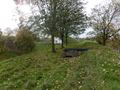
Finally I reached the historic city of Brielle (famous for its capture by Dutch forces during the Eighty Years' War, providing a turning point in their struggle for independence) and snapped a few pictures. The hash was located on one of the city's bastions. It was a bit tricky to access, as there was a fence on one side and a rather steep wall on the other, but it appeared to be open to the public (there was even a park bench located nearby). I parked my bike at the base of the city wall and climbed up it to reach the hash. Took a few pictures and rode home again.
Photos

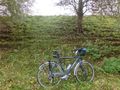
Let's see: Windmills, a bicycle (plus bike path), lush green pastures behind a dike, black-and-white cows, knotted willow trees and a village with two churches. We're definitely in Holland.

All the more interesting to find these kangaroos (wallabies? wallaroos? Any experts who can confirm?) nearby. I spotted one of them before.
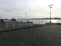
The ferry from Maassluis to Rozenburg. Note the multiple landing spots at differing heights, to account for differing water levels.
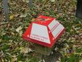
"Summertime 9am-6pm". That's what you get for blindly following a computer-generated route...

So instead of crossing straight into Brielle, I had to ride around this lake. Which was a nice ride after all.
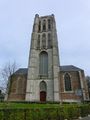
The 16th-century church of Brielle.
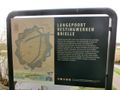
A sign showing the fortifications as they still exist today.
The hash is located right behind the top of this bit of city wall.
There are even still cannons ready to defend the city!
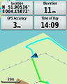
GPS proof.
Lloyd posing at the hash.
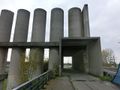
Interesting brutalist decorations on the bike path near Rozenburg.


Achievements
FelixTheCat (talk) earned the Bicycle geohash achievement
|