Difference between revisions of "2015-11-15 49 9"
imported>Uvok (→Plans: added plan) |
imported>FippeBot m (Location) |
||
| (3 intermediate revisions by one other user not shown) | |||
| Line 1: | Line 1: | ||
| − | |||
| − | |||
| − | |||
| − | |||
| − | |||
| − | |||
| − | |||
| − | |||
| − | |||
| − | |||
{{meetup graticule | {{meetup graticule | ||
| lat=49 | | lat=49 | ||
| Line 19: | Line 9: | ||
== Location == | == Location == | ||
| − | + | A field near Dertingen (Wertheim), close to the Autobahn A3 | |
== Participants == | == Participants == | ||
| Line 26: | Line 16: | ||
== Plans == | == Plans == | ||
Planning to be there around 14:00, maybe later, look around and walk a bit. Meetup point is directly on a field, won't go on it. Not sure if that counts as successful expedition then? | Planning to be there around 14:00, maybe later, look around and walk a bit. Meetup point is directly on a field, won't go on it. Not sure if that counts as successful expedition then? | ||
| − | |||
== Expedition == | == Expedition == | ||
| − | + | Actually only arrived at 15:00. It was quite cloudy and windy, not much enjoyable, but that's what warm clothes are for. | |
| + | |||
| + | I had to to a bit of "climbing", but it was on a path. It was really quiet, except for the A3, no one else to see there. It turned out I could walk directly to the geohash point, on the "field" was only grass, didn't look really cultivated, maybe the satellite pictures were quite old. | ||
| + | |||
| + | I walked around for a bit, did a coffee brake and found some twigs, out of which I left some marker. Let's see if anyone will find it, or how long it will last. | ||
| + | Afterward, I went through Dertingen itself by car. Was bigger than I expected. | ||
== Tracklog == | == Tracklog == | ||
| − | + | * [http://www.uvokchee.de/geohash-20151115.html Tracklog] created with GPS Visualizer (self-hosted) | |
== Photos == | == Photos == | ||
| Line 39: | Line 33: | ||
--> | --> | ||
<gallery perrow="5"> | <gallery perrow="5"> | ||
| + | File:20151115 49 9 parkcar.jpg | Where I parked my car. There was a construction area for the A3, I guess. | ||
| + | File:20151115 49 9 flowers.jpg | Some flowers on the construction area | ||
| + | File:20151115 49 9-Dertingen.jpg | An obstructed view to Dertingen | ||
| + | File:20151115 49 9-cargps.jpg | My car GPS | ||
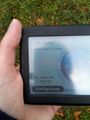
| + | File:2015-11-15-49-9-radar.png | and my smartphone GPS | ||
| + | File:20151115 49 9-panorama.jpg | A panorama of the geohash location | ||
| + | File:20151115 49 9-food.jpg | Coffee break! | ||
| + | File:20151115 49 9-marker.jpg | That's gonna leave a mark | ||
</gallery> | </gallery> | ||
| Line 45: | Line 47: | ||
<!-- Add any achievement ribbons you earned below, or remove this section --> | <!-- Add any achievement ribbons you earned below, or remove this section --> | ||
| − | + | Argh, missed the [[Picnic achievement]], didn't have the required accessories | |
| − | |||
| − | [[ | ||
| − | |||
| − | |||
| − | |||
| − | |||
| − | |||
| − | |||
| − | |||
| − | |||
[[Category:Expeditions]] | [[Category:Expeditions]] | ||
| − | |||
[[Category:Expeditions with photos]] | [[Category:Expeditions with photos]] | ||
| − | |||
| − | |||
| − | |||
| − | |||
| − | |||
[[Category:Coordinates reached]] | [[Category:Coordinates reached]] | ||
| − | + | {{location|DE|BW|TBB}} | |
| − | |||
| − | |||
| − | |||
| − | |||
| − | |||
| − | |||
| − | |||
| − | |||
| − | |||
| − | |||
| − | |||
| − | |||
| − | |||
| − | |||
| − | |||
| − | |||
| − | |||
Latest revision as of 05:51, 15 August 2019
| Sun 15 Nov 2015 in 49,9: 49.7606843, 9.6327538 geohashing.info google osm bing/os kml crox |
Location
A field near Dertingen (Wertheim), close to the Autobahn A3
Participants
Plans
Planning to be there around 14:00, maybe later, look around and walk a bit. Meetup point is directly on a field, won't go on it. Not sure if that counts as successful expedition then?
Expedition
Actually only arrived at 15:00. It was quite cloudy and windy, not much enjoyable, but that's what warm clothes are for.
I had to to a bit of "climbing", but it was on a path. It was really quiet, except for the A3, no one else to see there. It turned out I could walk directly to the geohash point, on the "field" was only grass, didn't look really cultivated, maybe the satellite pictures were quite old.
I walked around for a bit, did a coffee brake and found some twigs, out of which I left some marker. Let's see if anyone will find it, or how long it will last. Afterward, I went through Dertingen itself by car. Was bigger than I expected.
Tracklog
- Tracklog created with GPS Visualizer (self-hosted)
Photos
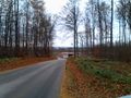
Where I parked my car. There was a construction area for the A3, I guess.
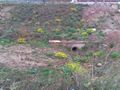
Some flowers on the construction area
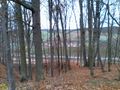
An obstructed view to Dertingen
My car GPS
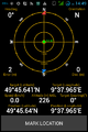
and my smartphone GPS
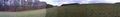
A panorama of the geohash location
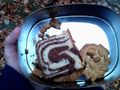
Coffee break!
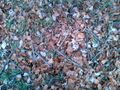
That's gonna leave a mark


Achievements
Argh, missed the Picnic achievement, didn't have the required accessories