Difference between revisions of "2015-11-29 45 16"
imported>GeoEdo |
imported>FippeBot m (Location) |
||
| (8 intermediate revisions by one other user not shown) | |||
| Line 7: | Line 7: | ||
== Location == | == Location == | ||
| − | + | In a field near Sop, a small settlement in Zagreb County, Croatia. | |
== Participants == | == Participants == | ||
| Line 14: | Line 14: | ||
== Expedition == | == Expedition == | ||
| − | This is my third geohashing expedition and my second successfully reached hashpoint. This hashpoint is about 11 kilometers from my home (as the crow flies). This geohashing expedition was part of entire day of geo-games that I played: ingress, geovexilla, monster cache, flagstack, geocaching, waymarking, and of course geohashing. I brought my | + | This is my third geohashing expedition and my second successfully reached hashpoint. This hashpoint is about 11 kilometers from my home (as the crow flies). This geohashing expedition was part of entire day of geo-games that I played: ingress, geovexilla, monster cache, flagstack, geocaching, waymarking, and of course geohashing. I brought my dad on this expedition but he didn't reached the actual hashpoint as he decided to stay in car. |
| − | I | + | I visited this hashpoint on the way back home from playing other geo-games. We were driving back home on A3 motorway and we exited the motorway near large IKEA center. I parked some 350 meters away from the hashpoint. The hashpoint was in the middle of field and between my car and hashpoint there were trees, bushes and high grass, so I wasn't sure if the hashpoint will be reachable. I found a route that was slightly less overgrown, so soon I managed to slowly decrease distance between me and hashpoint. I stumbled on two streams on my way to hashpoint, so I had to search for best location to jump over them. And finally, after walking through some really overgrown fields I managed to reach ground zero. Took screenshots and pictures as proofs of my visit, looked around a bit, and started my way back to my car. |
== Photos == | == Photos == | ||
| Line 24: | Line 24: | ||
Image:20151129_150954.jpg|Me standing at hashpoint | Image:20151129_150954.jpg|Me standing at hashpoint | ||
Image:20151129_151005.jpg|Tree near hashpoint | Image:20151129_151005.jpg|Tree near hashpoint | ||
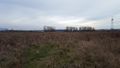
| − | Image:20151129_151008.jpg| | + | Image:20151129_151008.jpg|View from hashpoint: houses in Sop setllement |
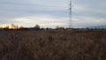
Image:20151129_151001.jpg|View from hashpoint | Image:20151129_151001.jpg|View from hashpoint | ||
Image:20151129_151226.jpg|Hashpoint is some 120 meters ahead, near tree | Image:20151129_151226.jpg|Hashpoint is some 120 meters ahead, near tree | ||
| Line 30: | Line 30: | ||
| + | == Achievements == | ||
| + | {{#vardefine:ribbonwidth|800px}} | ||
| + | |||
| + | {{Land geohash | ||
| + | |||
| + | | latitude = 45 | ||
| + | | longitude = 16 | ||
| + | | date = 2015-11-29 | ||
| + | | name = GeoEdo | ||
| + | |||
| + | }} | ||
| Line 35: | Line 46: | ||
[[Category:Expeditions with photos]] | [[Category:Expeditions with photos]] | ||
[[Category:Coordinates reached]] | [[Category:Coordinates reached]] | ||
| + | {{location|HR|01}} | ||
Latest revision as of 06:00, 15 August 2019
| Sun 29 Nov 2015 in 45,16: 45.7865146, 16.1550080 geohashing.info google osm bing/os kml crox |
Location
In a field near Sop, a small settlement in Zagreb County, Croatia.
Participants
Expedition
This is my third geohashing expedition and my second successfully reached hashpoint. This hashpoint is about 11 kilometers from my home (as the crow flies). This geohashing expedition was part of entire day of geo-games that I played: ingress, geovexilla, monster cache, flagstack, geocaching, waymarking, and of course geohashing. I brought my dad on this expedition but he didn't reached the actual hashpoint as he decided to stay in car.
I visited this hashpoint on the way back home from playing other geo-games. We were driving back home on A3 motorway and we exited the motorway near large IKEA center. I parked some 350 meters away from the hashpoint. The hashpoint was in the middle of field and between my car and hashpoint there were trees, bushes and high grass, so I wasn't sure if the hashpoint will be reachable. I found a route that was slightly less overgrown, so soon I managed to slowly decrease distance between me and hashpoint. I stumbled on two streams on my way to hashpoint, so I had to search for best location to jump over them. And finally, after walking through some really overgrown fields I managed to reach ground zero. Took screenshots and pictures as proofs of my visit, looked around a bit, and started my way back to my car.
Photos
Proof of correct location

Proof of correct date

Me standing at hashpoint
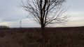
Tree near hashpoint
View from hashpoint: houses in Sop setllement
View from hashpoint
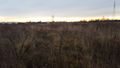
Hashpoint is some 120 meters ahead, near tree


Achievements
GeoEdo earned the Land geohash achievement
|