Difference between revisions of "2015-12-02 46 16"
imported>GeoEdo (→Expedition) |
imported>FippeBot m (Location) |
||
| (5 intermediate revisions by one other user not shown) | |||
| Line 18: | Line 18: | ||
I took A4 motorway to Ludbreg exit and from there I proceeded on D2 road towards west. My initial plan was to approach hashpoint from east so I left D2 in Bartolovec, a small settlement in Varazdin County with about 780 inhabitants. Local road in Bartolovec quickly turned into dirt road and abruptly ended with tree that somebody placed in the middle of the road creating barricade, no idea why. | I took A4 motorway to Ludbreg exit and from there I proceeded on D2 road towards west. My initial plan was to approach hashpoint from east so I left D2 in Bartolovec, a small settlement in Varazdin County with about 780 inhabitants. Local road in Bartolovec quickly turned into dirt road and abruptly ended with tree that somebody placed in the middle of the road creating barricade, no idea why. | ||
| − | I turned back and decided to try to approach hashpoint from the west, from Trnovec Bartolovecki. So, I returned back to D2 road and drove to Trnovec Bartolovecki and tried my luck with another set of local roads. After short drive through the settlement, the local road again turned to dirt road, and then to dirt "road". I pondered few times to stop my car and continue on foot but quickly decided that road is not that bad. I | + | I turned back and decided to try to approach hashpoint from the west, from Trnovec Bartolovecki. So, I returned back to D2 road and drove to Trnovec Bartolovecki and tried my luck with another set of local roads. After short drive through the settlement, the local road again turned to dirt road, and then to dirt "road". I pondered few times to stop my car and continue on foot but quickly decided that road is not that bad. While driving on that "road" I remembered relet's remark about blind monkey and Google Maps. |
| − | I took screenshots and pictures to prove my visit and then I returned to my car, drove through the dirt "road" again, back to D2 and A4 and after some 90 kilometers in opposite direction I arrived home. | + | I managed to park car some 30 meters form the hashpoint. From there I entered the forest, and after some 30 meters Geohashing app informed me that I arrived to the ground zero. I took screenshots and pictures to prove my visit and then I returned to my car, drove through the dirt "road" again, back to D2 and A4 and after some 90 kilometers in opposite direction I arrived home, happy that I reached another geohash. |
== Tracklog == | == Tracklog == | ||
| Line 31: | Line 31: | ||
== Photos == | == Photos == | ||
<gallery perrow="5"> | <gallery perrow="5"> | ||
| + | Image:20151202_155404.jpg|Barricade on the road | ||
| + | Image:Screenshot_2015-12-02-16-10-05.png|Proof of correct location | ||
| + | Image:Screenshot_2015-12-02-16-10-58.png|Proof of correct date | ||
| + | Image:20151202_161106.jpg|View from hashpoint | ||
| + | Image:20151202_161112.jpg|My car from hashpoint | ||
| + | Image:20151202_161207.jpg|Dirt "road" | ||
| + | Image:20151202_161219.jpg|Hashpoint is some 30 meters ahead | ||
| + | </gallery> | ||
| − | |||
== Achievements == | == Achievements == | ||
{{#vardefine:ribbonwidth|800px}} | {{#vardefine:ribbonwidth|800px}} | ||
| − | |||
| − | |||
| − | |||
| − | |||
| − | |||
| − | |||
| − | |||
| − | |||
{{Minesweeper geohash | {{Minesweeper geohash | ||
| graticule = Zagreb East, Croatia | | graticule = Zagreb East, Croatia | ||
| ranknumber = 1 | | ranknumber = 1 | ||
| − | | n = true | + | | n = true |
| name = GeoEdo | | name = GeoEdo | ||
}} | }} | ||
| + | {{Land geohash | ||
| + | | latitude = 46 | ||
| + | | longitude = 16 | ||
| + | | date = 2015-12-02 | ||
| + | | name = GeoEdo | ||
| + | |||
| + | }} | ||
[[Category:Expeditions]] | [[Category:Expeditions]] | ||
[[Category:Expeditions with photos]] | [[Category:Expeditions with photos]] | ||
[[Category:Coordinates reached]] | [[Category:Coordinates reached]] | ||
| + | {{location|HR|05}} | ||
Latest revision as of 01:31, 7 August 2019
| Wed 2 Dec 2015 in 46,16: 46.2883594, 16.4236225 geohashing.info google osm bing/os kml crox |
Location
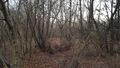
At the edge of small forest between Bartolovec and Trnovec Bartolovecki in Varazdin County, Croatia.
Participants
Expedition
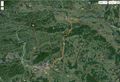
The Algorithm was generous to me today and came up with hashpoint that seemed quite doable (only about 50 meters from the road) and "only" 90 kilometers from my home location. And as additional bonus, it was located in virgin graticule that will also give me Minesweeper Geohash achievement. Obviously, I just had to go on expedition and try to reach this hashpoint.
I took A4 motorway to Ludbreg exit and from there I proceeded on D2 road towards west. My initial plan was to approach hashpoint from east so I left D2 in Bartolovec, a small settlement in Varazdin County with about 780 inhabitants. Local road in Bartolovec quickly turned into dirt road and abruptly ended with tree that somebody placed in the middle of the road creating barricade, no idea why.
I turned back and decided to try to approach hashpoint from the west, from Trnovec Bartolovecki. So, I returned back to D2 road and drove to Trnovec Bartolovecki and tried my luck with another set of local roads. After short drive through the settlement, the local road again turned to dirt road, and then to dirt "road". I pondered few times to stop my car and continue on foot but quickly decided that road is not that bad. While driving on that "road" I remembered relet's remark about blind monkey and Google Maps.
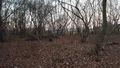
I managed to park car some 30 meters form the hashpoint. From there I entered the forest, and after some 30 meters Geohashing app informed me that I arrived to the ground zero. I took screenshots and pictures to prove my visit and then I returned to my car, drove through the dirt "road" again, back to D2 and A4 and after some 90 kilometers in opposite direction I arrived home, happy that I reached another geohash.
Tracklog
Expedition tracklog

Expedition tracklog on Wikiloc
Photos
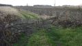
Barricade on the road
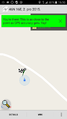
Proof of correct location

Proof of correct date
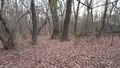
View from hashpoint
My car from hashpoint
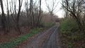
Dirt "road"
Hashpoint is some 30 meters ahead


Achievements
GeoEdo achieved level 1 of the Minesweeper Geohash achievement
|
GeoEdo earned the Land geohash achievement
|