Difference between revisions of "2015-12-26 49 8"
imported>DODO |
imported>FippeBot m (Location) |
||
| (6 intermediate revisions by one other user not shown) | |||
| Line 28: | Line 28: | ||
== Plans == | == Plans == | ||
<!-- what were the original plans --> | <!-- what were the original plans --> | ||
| − | + | I was at my mothers home on christmas but had to drive home today. So I want to visit hashes near the road. | |
| + | |||
== Expedition == | == Expedition == | ||
<!-- how it all turned out. your narrative goes here. --> | <!-- how it all turned out. your narrative goes here. --> | ||
| − | + | The hash god was on my side and placed this hash just 10 KM next to the autobahn (as the crow flies). I couldn't resist to visit it. | |
| + | |||
| + | So I left the autobahn A61 and changed to the autobahn A63 and parked in Udenbach after a 15 kilometer drive less than 15 minutes later. I enjoyed the little walk between all the driving and reached the hashfield another 10 minutes later. I had to walk for 55m into the fresh planted field but there was a tractor track leading in the right direction so I harmed hardly any plants. After the obligatory pictures I decided to walk a little longer to circle the hash. After 3 kilometers (and half an hour) I reached my car again, drove the 15 km back to the A61 and continued my ride home. | ||
| + | |||
== Tracklog == | == Tracklog == | ||
<!-- if your GPS device keeps a log, you may post a link here --> | <!-- if your GPS device keeps a log, you may post a link here --> | ||
| − | + | [https://www.komoot.de/tour/7566858/zoom 207 KM by car (30 km detour), 3 KM walk] . Here is only the the [http://www.gpsies.com/map.do?fileId=hqlwkwckwffvvreo 3 KM walk] | |
| + | |||
== Photos == | == Photos == | ||
<!-- Insert pictures between the gallery tags using the following format: | <!-- Insert pictures between the gallery tags using the following format: | ||
| Line 40: | Line 45: | ||
--> | --> | ||
<gallery perrow="5"> | <gallery perrow="5"> | ||
| + | Image:2015-12-26_49_8-1.jpg|I left little car in Udenbach | ||
| + | Image:2015-12-26_49_8-2.jpg|first view to the hash field (the small green one between the two brown ones) | ||
| + | Image:2015-12-26_49_8-3.jpg|55 m in this direction | ||
| + | Image:2015-12-26_49_8-4.jpg|view back to Udenbach | ||
| + | Image:2015-12-26_49_8-5.jpg|proof | ||
| + | Image:2015-12-26_49_8-9.png|another proof | ||
| + | Image:2015-12-26_49_8-6.jpg|view from the hash (pretty much the same in all four directions, except my shadow) | ||
| + | Image:2015-12-26_49_8-7.jpg|happy hasher | ||
| + | Image:2015-12-26_49_8-8.jpg|hashfield from the south (150 m in this direction) | ||
</gallery> | </gallery> | ||
| − | + | ||
== Achievements == | == Achievements == | ||
{{#vardefine:ribbonwidth|800px}} | {{#vardefine:ribbonwidth|800px}} | ||
| Line 48: | Line 62: | ||
| latitude = 49 | | latitude = 49 | ||
| longitude = 8 | | longitude = 8 | ||
| − | | date = 2015-12- | + | | date = 2015-12-26 |
| name = DODO | | name = DODO | ||
}} | }} | ||
| + | |||
| + | Thanks to [[User:Q-Owl|Q-Owl]] for this ribbon: | ||
| + | {{gratuitous ribbon | ||
| + | | color = orange | ||
| + | | icon = ChristmasTree.PNG | ||
| + | | latitude = 49 | ||
| + | | longitude = 8 | ||
| + | | date = 2015-12-26 | ||
| + | | achievement = Christmas achievement | ||
| + | | description = geohashing on Christmas (Dec. 26. 2015) | ||
| + | | name = DODO | ||
| + | }} | ||
[[Category:Expeditions]] | [[Category:Expeditions]] | ||
| Line 57: | Line 83: | ||
[[Category:Coordinates reached]] | [[Category:Coordinates reached]] | ||
| + | {{location|DE|RP|MZ}} | ||
Latest revision as of 06:15, 15 August 2019
| Sat 26 Dec 2015 in 49,8: 49.8379112, 8.2073364 geohashing.info google osm bing/os kml crox |
Location
A field near Undenheim
Participants
Plans
I was at my mothers home on christmas but had to drive home today. So I want to visit hashes near the road.
Expedition
The hash god was on my side and placed this hash just 10 KM next to the autobahn (as the crow flies). I couldn't resist to visit it.
So I left the autobahn A61 and changed to the autobahn A63 and parked in Udenbach after a 15 kilometer drive less than 15 minutes later. I enjoyed the little walk between all the driving and reached the hashfield another 10 minutes later. I had to walk for 55m into the fresh planted field but there was a tractor track leading in the right direction so I harmed hardly any plants. After the obligatory pictures I decided to walk a little longer to circle the hash. After 3 kilometers (and half an hour) I reached my car again, drove the 15 km back to the A61 and continued my ride home.
Tracklog
207 KM by car (30 km detour), 3 KM walk . Here is only the the 3 KM walk
Photos
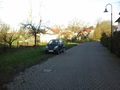
I left little car in Udenbach
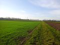
first view to the hash field (the small green one between the two brown ones)
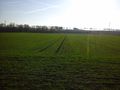
55 m in this direction
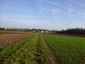
view back to Udenbach
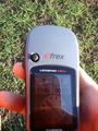
proof
another proof
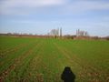
view from the hash (pretty much the same in all four directions, except my shadow)

happy hasher
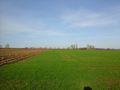
hashfield from the south (150 m in this direction)


Achievements
DODO earned the Land geohash achievement
|
Thanks to Q-Owl for this ribbon:
DODO earned the Christmas achievement
|