Difference between revisions of "2016-03-13 42 -72"
imported>SlumberBear (→Expedition) |
imported>FippeBot m (Location) |
||
| (4 intermediate revisions by 2 users not shown) | |||
| Line 1: | Line 1: | ||
| − | |||
| − | |||
| − | |||
| − | |||
| − | |||
| − | |||
| − | |||
| − | |||
| − | |||
| − | |||
{{meetup graticule | {{meetup graticule | ||
| lat=42 | | lat=42 | ||
| Line 14: | Line 4: | ||
| date=2016-03-13 | | date=2016-03-13 | ||
}} | }} | ||
| − | |||
| − | |||
| − | |||
== Location == | == Location == | ||
| Line 22: | Line 9: | ||
== Participants == | == Participants == | ||
| − | [[User:SlumberBear|SlumberBear]] | + | |
| + | * [[User:SlumberBear|SlumberBear]], | ||
| + | * Dad | ||
== Plans == | == Plans == | ||
| Line 28: | Line 17: | ||
== Expedition == | == Expedition == | ||
| − | We ended up driving up the road on the east side of the lake and walking down a dangerously hilly power line trail. The hash was about 200 feet off of the clearing. After that, we decided to hike to the nearest geocache, "just" 0.3 miles away. We continued down the clearing before taking a left on an actual trail. The cache ended up being a bit further north, and was very well hidden under leaves after six months of not being found. On the way back, we hiked in the woods instead of on the rocky clearing, and found an old logging road. | + | We ended up driving up the road on the east side of the lake and walking down a dangerously hilly power line trail. The hash was about 200 feet off of the clearing. After that, we decided to hike to the nearest geocache, "just" 0.3 miles away. We continued down the clearing before taking a left on an actual trail. |
| + | |||
| + | The cache ended up being a bit further north, and was very well hidden under leaves after six months of not being found. On the way back, we hiked in the woods instead of on the rocky clearing, and found an old logging road. | ||
I would say that we are crazy and we would never do this again, but we actually are crazy. So of course we'll always be ready for the adventure. | I would say that we are crazy and we would never do this again, but we actually are crazy. So of course we'll always be ready for the adventure. | ||
== Tracklog == | == Tracklog == | ||
| − | + | http://www.filedropper.com/geohash413-03-15 | |
== Photos == | == Photos == | ||
| − | |||
| − | |||
| − | |||
<gallery perrow="5"> | <gallery perrow="5"> | ||
| + | Image:13-03-16 big tree.JPG | Our first road choice brought us to a nice view and a big tree. | ||
| + | Image:13-03-16 sugarshack.JPG | Hurrah! A lunch oasis. | ||
| + | Image:2016-03-13 bridge.JPG | The clearing was flooded, and so was the side trail. | ||
| + | Image:2016-03-13 car.JPG | Well, no going back now. | ||
| + | Image:2016-03-13 long way.JPG | A long way to go. Pretty though. | ||
| + | Image:2016-03-13 turn off.JPG | Turning off the clearing towards the hash. | ||
| + | Image:2016-03-13 grin.JPG | Obligatory. With a puppy! Yay! | ||
| + | Image:2016-03-13 hash.JPG | Hash location. | ||
| + | Image:2016-03-13 proof.JPG | 19 feet is close enough for me. | ||
| + | Image:2016-03-13 oh boy.JPG | Moving on to the cache, we realized how far we had to go. Oh boy. | ||
| + | Image:2016-03-13 hill.JPG | Aren't hills fun? | ||
| + | Image:2016-03-13 stream.JPG| Pretty stream. | ||
| + | Image:2016-03-13 logging road.JPG | The logging road we took back to the car. | ||
</gallery> | </gallery> | ||
| − | == | + | == Videos == |
| − | + | Geocache we found, buried in leaves. — https://youtu.be/dM0ozWsqM64 | |
| − | + | And, we're out! — https://youtu.be/ucGd4egrlMU | |
| − | |||
| − | |||
| − | |||
| − | |||
| − | |||
| − | |||
| − | |||
| − | |||
| − | |||
| − | |||
| − | |||
| − | |||
[[Category:Expeditions]] | [[Category:Expeditions]] | ||
| − | |||
[[Category:Expeditions with photos]] | [[Category:Expeditions with photos]] | ||
[[Category:Expeditions with videos]] | [[Category:Expeditions with videos]] | ||
| − | |||
| − | |||
| − | |||
| − | |||
[[Category:Coordinates reached]] | [[Category:Coordinates reached]] | ||
| − | + | [[Category: Meetup on 2016-03-13]] | |
| − | + | [[Category: Meetup in 42 -72]] | |
| − | + | {{location|US|MA|HS}} | |
| − | [[Category: | ||
| − | |||
| − | |||
| − | |||
| − | |||
| − | |||
| − | [[Category: | ||
| − | |||
| − | |||
| − | |||
| − | |||
| − | |||
| − | |||
| − | |||
| − | |||
Latest revision as of 01:42, 7 August 2019
| Sun 13 Mar 2016 in 42,-72: 42.3137448, -72.8392283 geohashing.info google osm bing/os kml crox |
Location
Hiram H. Fox Wildlife Refuge in Huntington, MA.
Participants
- SlumberBear,
- Dad
Plans
Drive to Pisgah Road and find where the trail intercepts. Walk in and find the geohash and a geocache.
Expedition
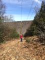
We ended up driving up the road on the east side of the lake and walking down a dangerously hilly power line trail. The hash was about 200 feet off of the clearing. After that, we decided to hike to the nearest geocache, "just" 0.3 miles away. We continued down the clearing before taking a left on an actual trail.
The cache ended up being a bit further north, and was very well hidden under leaves after six months of not being found. On the way back, we hiked in the woods instead of on the rocky clearing, and found an old logging road.
I would say that we are crazy and we would never do this again, but we actually are crazy. So of course we'll always be ready for the adventure.
Tracklog
http://www.filedropper.com/geohash413-03-15
Photos
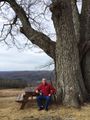
Our first road choice brought us to a nice view and a big tree.
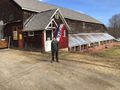
Hurrah! A lunch oasis.
The clearing was flooded, and so was the side trail.
Well, no going back now.
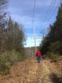
A long way to go. Pretty though.
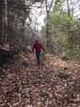
Turning off the clearing towards the hash.
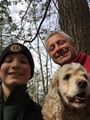
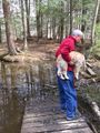
Obligatory. With a puppy! Yay!
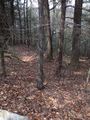
Hash location.
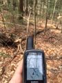
19 feet is close enough for me.
Moving on to the cache, we realized how far we had to go. Oh boy.
Aren't hills fun?
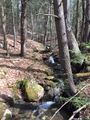
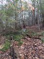
Pretty stream.
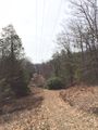
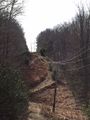
The logging road we took back to the car.


Videos
Geocache we found, buried in leaves. — https://youtu.be/dM0ozWsqM64 And, we're out! — https://youtu.be/ucGd4egrlMU