Difference between revisions of "2016-03-19 49 8"
imported>DODO (→Participants) |
imported>FippeBot m (Location) |
||
| (5 intermediate revisions by one other user not shown) | |||
| Line 29: | Line 29: | ||
== Plans == | == Plans == | ||
<!-- what were the original plans --> | <!-- what were the original plans --> | ||
| + | Go there on my bull on my way to the rowing club. | ||
== Expedition == | == Expedition == | ||
<!-- how it all turned out. your narrative goes here. --> | <!-- how it all turned out. your narrative goes here. --> | ||
| + | I had an appointment at the rowing club at 14:30 and todays hashpoint was quite close to the club. So I decided to come along on my way there. I started at 1 pm and kept on the left side of the rhine river. I used the meanwhile well know ferry but missed to take a picture of the nearby power plant today. I had to wait for the ferry for some time so I reached the right shore of the river at 13:55. But I decided that that would still be enough to reach the hp and be back at the club in time. I hurried through Neckarau and quickly reached Almenhof. The hp was easy to reach, just at the entrance of a house. On the other side of the street was a hospital. I took some quick pictures and hurried on. | ||
| + | |||
| + | I reached the rowing club just in time at 14:25. After rowing I continued my trip home on the right side of the river and so I can present a perfect ton (except of the rowing kilometers of course). | ||
== Tracklog == | == Tracklog == | ||
<!-- if your GPS device keeps a log, you may post a link here --> | <!-- if your GPS device keeps a log, you may post a link here --> | ||
| + | [https://www.komoot.de/tour/8143116 51 KM bull-riding]. For those who wonder what the second pause in the speed-profile ist from: I had some nice ice-cream on my way home. | ||
== Photos == | == Photos == | ||
| Line 40: | Line 45: | ||
Image:2012-##-## ## ## Alpha.jpg | Witty Comment | Image:2012-##-## ## ## Alpha.jpg | Witty Comment | ||
--> | --> | ||
| − | <gallery perrow=" | + | <gallery perrow="6"> |
| + | Image:2016-03-19_49_8-6.png|proof | ||
| + | Image:2016-03-19_49_8-5.jpg|the hash is at the entrance of that house | ||
| + | Image:2016-03-19_49_8-2.jpg|proof of transport | ||
| + | Image:2016-03-19_49_8-3.jpg|and of hasher | ||
| + | Image:2016-03-19_49_8-1.jpg|view from the hash to the hospital | ||
| + | Image:2016-03-19_49_8-4.jpg|and in the other direction | ||
</gallery> | </gallery> | ||
| Line 46: | Line 57: | ||
{{#vardefine:ribbonwidth|800px}} | {{#vardefine:ribbonwidth|800px}} | ||
<!-- Add any achievement ribbons you earned below, or remove this section --> | <!-- Add any achievement ribbons you earned below, or remove this section --> | ||
| + | {{land geohash | ||
| + | | latitude = 49 | ||
| + | | longitude = 8 | ||
| + | | date = 2016-03-19 | ||
| + | | name = DODO | ||
| + | }} | ||
| − | + | {{Template:Tron | |
| − | + | | latitude = 49 | |
| − | + | | longitude = 8 | |
| − | + | | date = 2016-03-19 | |
| − | + | | name = DODO | |
| − | + | | possessive = his | |
| − | + | }} | |
| − | |||
| − | |||
| − | |||
[[Category:Expeditions]] | [[Category:Expeditions]] | ||
| − | |||
[[Category:Expeditions with photos]] | [[Category:Expeditions with photos]] | ||
| − | |||
| − | |||
| − | |||
| − | |||
| − | |||
[[Category:Coordinates reached]] | [[Category:Coordinates reached]] | ||
| − | + | {{location|DE|BW|MA}} | |
| − | |||
| − | |||
| − | |||
| − | |||
| − | |||
| − | |||
| − | |||
| − | |||
| − | |||
| − | |||
| − | |||
| − | |||
| − | |||
| − | |||
| − | |||
| − | |||
| − | |||
Latest revision as of 06:57, 15 August 2019
| Sat 19 Mar 2016 in 49,8: 49.4639572, 8.4691540 geohashing.info google osm bing/os kml crox |
Location
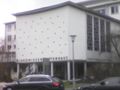
The entrance of a house next to the Diakonissen-Hospital in Mannheim-Almenhof.
Participants
Plans
Go there on my bull on my way to the rowing club.
Expedition
I had an appointment at the rowing club at 14:30 and todays hashpoint was quite close to the club. So I decided to come along on my way there. I started at 1 pm and kept on the left side of the rhine river. I used the meanwhile well know ferry but missed to take a picture of the nearby power plant today. I had to wait for the ferry for some time so I reached the right shore of the river at 13:55. But I decided that that would still be enough to reach the hp and be back at the club in time. I hurried through Neckarau and quickly reached Almenhof. The hp was easy to reach, just at the entrance of a house. On the other side of the street was a hospital. I took some quick pictures and hurried on.
I reached the rowing club just in time at 14:25. After rowing I continued my trip home on the right side of the river and so I can present a perfect ton (except of the rowing kilometers of course).
Tracklog
51 KM bull-riding. For those who wonder what the second pause in the speed-profile ist from: I had some nice ice-cream on my way home.
Photos
proof
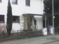
the hash is at the entrance of that house
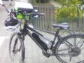
proof of transport
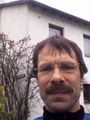
and of hasher
view from the hash to the hospital
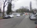
and in the other direction


Achievements
DODO earned the Land geohash achievement
|
DODO earned the Tron achievement
|