Difference between revisions of "2016-04-03 44 -120"
From Geohashing
imported>Gldminer (An expedition message sent via Geohash Droid for Android.) |
m |
||
| (4 intermediate revisions by 3 users not shown) | |||
| Line 24: | Line 24: | ||
<!-- who attended: If you link to your wiki user name in this section, your expedition will be picked up by the various statistics generated for geohashing. You may use three tildes ~ as a shortcut to automatically insert the user signature of the account you are editing with. | <!-- who attended: If you link to your wiki user name in this section, your expedition will be picked up by the various statistics generated for geohashing. You may use three tildes ~ as a shortcut to automatically insert the user signature of the account you are editing with. | ||
--> | --> | ||
| + | *[[User:gldminer|gldminer]] | ||
== Plans == | == Plans == | ||
| Line 39: | Line 40: | ||
--> | --> | ||
<gallery perrow="5"> | <gallery perrow="5"> | ||
| + | |||
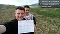
| + | Image:2016-04-03_44_-120_gldminer_1459752096707.jpg|Posting this for April 1. 1st hash. Was a lot of fun. Brought the wife along and tried to explain geohashing, but got glazed eyes. She said that she says nothing because she would rather see me smile than go drinking | ||
| + | or gambling. She considers it a fresh air tour after over an hour drive 1 way. [http://www.openstreetmap.org/?lat=44.06046850&lon=-121.27471920&zoom=16&layers=B000FTF @44.0605,-121.2747] | ||
| + | |||
| + | Image:2016-04-03_44_-120_gldminer_1459752389590.jpg|Another pic for 4-1-16. Little miner | ||
| + | along as well. [http://www.openstreetmap.org/?lat=44.06046360&lon=-121.27464880&zoom=16&layers=B000FTF @44.0605,-121.2746] | ||
</gallery> | </gallery> | ||
== Achievements == | == Achievements == | ||
{{#vardefine:ribbonwidth|800px}} | {{#vardefine:ribbonwidth|800px}} | ||
| − | |||
| − | |||
| − | |||
| − | |||
| − | |||
| − | |||
| − | |||
| − | |||
| − | |||
| − | |||
| − | |||
| − | |||
| − | |||
[[Category:Expeditions]] | [[Category:Expeditions]] | ||
| − | |||
[[Category:Expeditions with photos]] | [[Category:Expeditions with photos]] | ||
| − | |||
| − | |||
| − | |||
| − | |||
| − | |||
[[Category:Coordinates reached]] | [[Category:Coordinates reached]] | ||
| − | + | {{location|US|OR|WE}} | |
| − | |||
| − | |||
| − | |||
| − | |||
| − | |||
| − | |||
| − | |||
| − | |||
| − | |||
| − | |||
| − | |||
| − | |||
| − | |||
| − | |||
| − | |||
| − | |||
| − | |||
Latest revision as of 14:49, 18 March 2022
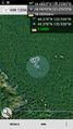
| Sun 3 Apr 2016 in 44,-120: 44.4860657, -120.2538264 geohashing.info google osm bing/os kml crox |
Location
Participants
Plans
Expedition
Tracklog
Photos
Posting this for April 1. 1st hash. Was a lot of fun. Brought the wife along and tried to explain geohashing, but got glazed eyes. She said that she says nothing because she would rather see me smile than go drinking
Another pic for 4-1-16. Little miner

