Difference between revisions of "2016-05-20 -37 144"
From Geohashing
imported>Felix Dance (An expedition message sent via Geohash Droid for Android.) |
m |
||
| (8 intermediate revisions by 3 users not shown) | |||
| Line 1: | Line 1: | ||
| − | |||
| − | |||
| − | |||
| − | |||
| − | |||
| − | |||
| − | |||
| − | |||
| − | |||
| − | |||
{{meetup graticule | {{meetup graticule | ||
| lat=-37 | | lat=-37 | ||
| Line 15: | Line 5: | ||
}} | }} | ||
| − | |||
__NOTOC__ | __NOTOC__ | ||
== Location == | == Location == | ||
<!-- where you've surveyed the hash to be --> | <!-- where you've surveyed the hash to be --> | ||
| + | Inside the reserve of the Princess Freeway near Werribee, south west of Melbourne. | ||
== Participants == | == Participants == | ||
| − | + | *[[User:Felix Dance|Felix Dance]] | |
| − | |||
| − | == | + | == Expedition == |
| − | + | Saw this location in the morning and determined to do it. Went to a movie with mate Tom ('Sherpa'), then rode out along the Federation Trail in the afternoon to reach the point. | |
| − | + | Found the spot, right inside the base of a big old tree it seemed, then turned around and rode back home in the dusk. Spent the ride in thinking about laser-propelled starships. | |
| − | |||
| − | + | [https://goo.gl/maps/nNRKU5CfHuN2 Here] is the route I took. | |
| − | |||
== Photos == | == Photos == | ||
| − | |||
| − | |||
| − | |||
<gallery perrow="5"> | <gallery perrow="5"> | ||
| + | |||
| + | Image:2016-05-20_-37_144_Felix Dance_1463726223627.jpg|Werribee success! [http://www.openstreetmap.org/?lat=-37.91665550&lon=144.66587750&zoom=16&layers=B000FTF @-37.9167,144.6659] | ||
| + | |||
| + | Image:2016-05-20_-37_144_Felix Dance_1463726267842.jpg|Big gum tree right at the hash [http://www.openstreetmap.org/?lat=-37.91668780&lon=144.66585260&zoom=16&layers=B000FTF @-37.9167,144.6659] | ||
| + | |||
| + | Image:2016-05-20_-37_144_Felix Dance_1463726309054.jpg|My bike waits for me near the hash [http://www.openstreetmap.org/?lat=-37.91642370&lon=144.66604750&zoom=16&layers=B000FTF @-37.9164,144.6660] | ||
| + | |||
| + | Image:2016-05-20_-37_144_Felix Dance_1463726332446.jpg|GPS proof at geohash [http://www.openstreetmap.org/?lat=-37.91653550&lon=144.66596940&zoom=16&layers=B000FTF @-37.9165,144.6660] | ||
</gallery> | </gallery> | ||
== Achievements == | == Achievements == | ||
| − | {{ | + | {{bicycle geohash |
| − | |||
| − | |||
| − | |||
| − | |||
| − | |||
| − | + | | latitude = -37 | |
| − | + | | longitude = 144 | |
| − | [[ | + | | date = 2016-05-20 |
| − | -- | + | | name = [[User:Felix Dance|Felix Dance]] |
| + | | distance = 75kms | ||
| + | | bothways = true | ||
| + | | image = 2016-05-20_-37_144_Felix Dance_1463726309054.jpg | ||
| − | + | }} | |
| − | |||
[[Category:Expeditions]] | [[Category:Expeditions]] | ||
| − | + | [[Category:Coordinates reached]] | |
[[Category:Expeditions with photos]] | [[Category:Expeditions with photos]] | ||
| − | + | {{location|AU|VIC|WY}} | |
| − | |||
| − | |||
| − | |||
| − | |||
| − | |||
| − | |||
| − | |||
| − | |||
| − | |||
| − | |||
| − | |||
| − | |||
| − | |||
| − | |||
| − | |||
| − | |||
| − | |||
| − | |||
| − | |||
| − | |||
| − | |||
| − | |||
| − | |||
Latest revision as of 10:22, 12 September 2021
| Fri 20 May 2016 in -37,144: -37.9166359, 144.6658901 geohashing.info google osm bing/os kml crox |
Location
Inside the reserve of the Princess Freeway near Werribee, south west of Melbourne.
Participants
Expedition
Saw this location in the morning and determined to do it. Went to a movie with mate Tom ('Sherpa'), then rode out along the Federation Trail in the afternoon to reach the point.
Found the spot, right inside the base of a big old tree it seemed, then turned around and rode back home in the dusk. Spent the ride in thinking about laser-propelled starships.
Here is the route I took.
Photos
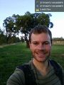
Werribee success! @-37.9167,144.6659
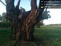
Big gum tree right at the hash @-37.9167,144.6659
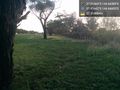
My bike waits for me near the hash @-37.9164,144.6660
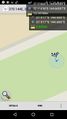
GPS proof at geohash @-37.9165,144.6660


Achievements
Felix Dance earned the Bicycle geohash achievement
|