Difference between revisions of "2016-05-23 49 11"
From Geohashing
imported>Schnatterfleck ([live picture]On the way - with best regards from Albrecht Dürer [http://www.openstreetmap.org/?lat=49.46673450&lon=11.04423580&zoom=16&layers=B000FTF @49.4667,11.0442]) |
m |
||
| (13 intermediate revisions by 4 users not shown) | |||
| Line 24: | Line 24: | ||
<!-- who attended: If you link to your wiki user name in this section, your expedition will be picked up by the various statistics generated for geohashing. You may use three tildes ~ as a shortcut to automatically insert the user signature of the account you are editing with. | <!-- who attended: If you link to your wiki user name in this section, your expedition will be picked up by the various statistics generated for geohashing. You may use three tildes ~ as a shortcut to automatically insert the user signature of the account you are editing with. | ||
--> | --> | ||
| + | *[[User:Schnatterfleck|Schnatterfleck]] | ||
== Plans == | == Plans == | ||
| Line 41: | Line 42: | ||
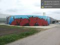
Image:2016-05-23_49_11_Schnatterfleck_1464030467064.jpg|On the way - with best regards from Albrecht Dürer [http://www.openstreetmap.org/?lat=49.46673450&lon=11.04423580&zoom=16&layers=B000FTF @49.4667,11.0442] | Image:2016-05-23_49_11_Schnatterfleck_1464030467064.jpg|On the way - with best regards from Albrecht Dürer [http://www.openstreetmap.org/?lat=49.46673450&lon=11.04423580&zoom=16&layers=B000FTF @49.4667,11.0442] | ||
| − | |||
| − | == | + | Image:2016-05-23_49_11_Schnatterfleck_1464030786958.jpg|Hashpoint somewhere in the middle of this building. [http://www.openstreetmap.org/?lat=49.46673170&lon=11.04423890&zoom=16&layers=B000FTF @49.4667,11.0442] |
| − | + | ||
| − | + | Image:2016-05-23_49_11_Schnatterfleck_1464031036173.jpg|Building is a parking house, so entrace is possible! | |
| + | Showing Hashpoint at the Lowest Level. [http://www.openstreetmap.org/?lat=49.46673340&lon=11.04422690&zoom=16&layers=B000FTF @49.4667,11.0442] | ||
| + | |||
| + | Image:2016-05-23_49_11_Schnatterfleck_1464031155463.jpg|At hashpoint - roof level. [http://www.openstreetmap.org/?lat=49.46673020&lon=11.04423050&zoom=16&layers=B000FTF @49.4667,11.0442] | ||
| + | |||
| + | Image:2016-05-23_49_11_Schnatterfleck_1464031282757.jpg|More than excellent mobile reception at the hashpoint:-) [http://www.openstreetmap.org/?lat=49.46672810&lon=11.04422900&zoom=16&layers=B000FTF @49.4667,11.0442] | ||
| − | + | Image:2016-05-23_49_11_Schnatterfleck_1464031344528.jpg|Terminal with Tower. [http://www.openstreetmap.org/?lat=49.46673380&lon=11.04422970&zoom=16&layers=B000FTF @49.4667,11.0442] | |
| − | |||
| − | |||
| − | + | Image:2016-05-23_49_11_Schnatterfleck_1464031410519.jpg|Terminal and view to runway. [http://www.openstreetmap.org/?lat=49.46673880&lon=11.04423820&zoom=16&layers=B000FTF @49.4667,11.0442] | |
| − | |||
| − | |||
| − | |||
| − | + | Image:2016-05-23_49_11_Schnatterfleck_1464031585493.jpg|Up and away! [http://www.openstreetmap.org/?lat=49.46673620&lon=11.04421720&zoom=16&layers=B000FTF @49.4667,11.0442] | |
| − | + | Image:2016-05-23_49_11_Schnatterfleck_1464031786496.jpg|View of Almoshof, Some of the Nürnberg Skyline in the background. [http://www.openstreetmap.org/?lat=49.46671620&lon=11.04424380&zoom=16&layers=B000FTF @49.4667,11.0442] | |
| − | |||
| − | -- | ||
| − | |||
| − | |||
| − | |||
| − | |||
| − | |||
| − | |||
| − | |||
| + | Image:2016-05-23_49_11_Schnatterfleck_1464031888462.jpg|The area near the airport grows some of the best strawberrys I ever tasted. [http://www.openstreetmap.org/?lat=49.46673300&lon=11.04425120&zoom=16&layers=B000FTF @49.4667,11.0443] | ||
| − | + | Image:2016-05-23_49_11_Schnatterfleck_1464031960321.jpg|A strawberry automaton. [http://www.openstreetmap.org/?lat=49.46673170&lon=11.04424550&zoom=16&layers=B000FTF @49.4667,11.0442] | |
| − | + | </gallery> | |
| − | |||
| − | |||
| − | |||
| − | |||
| − | |||
| − | |||
| − | + | == Achievements == | |
| − | + | {{#vardefine:ribbonwidth|800px}} | |
| − | |||
| − | |||
| − | |||
| − | + | [[Category:Expeditions]] | |
| + | [[Category:Expeditions with photos]] | ||
| + | [[Category:Coordinates reached]] | ||
| + | {{location|DE|BY|N}} | ||
Latest revision as of 11:43, 27 March 2022
| Mon 23 May 2016 in 49,11: 49.4933109, 11.0791717 geohashing.info google osm bing/os kml crox |
Location
Participants
Plans
Expedition
Tracklog
Photos
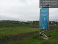
On the way - with best regards from Albrecht Dürer @49.4667,11.0442
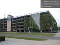
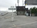
Hashpoint somewhere in the middle of this building. @49.4667,11.0442
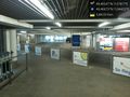
Building is a parking house, so entrace is possible!
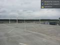
At hashpoint - roof level. @49.4667,11.0442
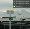
More than excellent mobile reception at the hashpoint:-) @49.4667,11.0442
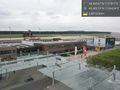
Terminal with Tower. @49.4667,11.0442
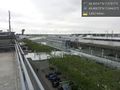
Terminal and view to runway. @49.4667,11.0442
Up and away! @49.4667,11.0442
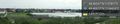
View of Almoshof, Some of the Nürnberg Skyline in the background. @49.4667,11.0442
The area near the airport grows some of the best strawberrys I ever tasted. @49.4667,11.0443
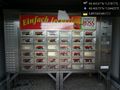
A strawberry automaton. @49.4667,11.0442


