Difference between revisions of "2016-06-10 52 1"
From Geohashing
imported>Sourcerer (→Planning) |
m |
||
| (8 intermediate revisions by 2 users not shown) | |||
| Line 13: | Line 13: | ||
== Plans == | == Plans == | ||
| − | + | Two of two spanning midnight - [[2016-06-09 52 0]] - [[2016-06-10 52 1]] - ETA 00:00. | |
== Participants == | == Participants == | ||
| Line 19: | Line 19: | ||
[[User:Sourcerer|Sourcerer]] | [[User:Sourcerer|Sourcerer]] | ||
| − | == Expedition == | + | == Expedition - Fail == |
| − | |||
| + | Many golf courses are open in several places. This one was well fenced and there was a road barrier and CCTV. It was obvious that intruders would not be welcome. A second line of approach was fenced even more thoroughly. | ||
== Photos == | == Photos == | ||
<gallery perrow="5"> | <gallery perrow="5"> | ||
| + | Image:2016-06-10_52_1_Sourcerer_1465513233634.jpg | Foiled. | ||
| + | Image:2016-06-10 52 1 Sourcerer.jpg | Google Earth Track | ||
</gallery> | </gallery> | ||
| Line 31: | Line 33: | ||
{{#vardefine:ribbonwidth|800px}} | {{#vardefine:ribbonwidth|800px}} | ||
| + | {{OpenStreetMap achievement | ||
| + | | latitude = 52 | ||
| + | | longitude = 1 | ||
| + | | date = 2016-06-10 | ||
| + | | OSMlink = 39930620 | ||
| + | | name = Sourcerer | ||
| + | }} | ||
{{Sourcerer_links | {{Sourcerer_links | ||
| − | | prev = 2016-06- | + | | prev = 2016-06-09 52 0 |
| curr = 2016-06-10 52 1 | | curr = 2016-06-10 52 1 | ||
| next = 2016-06-11 52 1 | | next = 2016-06-11 52 1 | ||
| Line 39: | Line 48: | ||
}} | }} | ||
| − | |||
| − | |||
[[Category:Expeditions]] | [[Category:Expeditions]] | ||
[[Category:Expeditions with photos]] | [[Category:Expeditions with photos]] | ||
| − | [[Category:Coordinates reached]] | + | [[Category:Coordinates not reached]] |
| − | - | + | [[Category:Not reached - No public access]] |
| + | {{location|GB|ENG|SFK}} | ||
Latest revision as of 11:39, 27 March 2022
| Fri 10 Jun 2016 in Norwich, UK: 52.0395666, 1.2099033 geohashing.info google osm bing/os kml crox |
Location
A golf course point at Bixley Heath, Ipswich, Suffolk, UK.
Plans
Two of two spanning midnight - 2016-06-09 52 0 - 2016-06-10 52 1 - ETA 00:00.
Participants
Expedition - Fail
Many golf courses are open in several places. This one was well fenced and there was a road barrier and CCTV. It was obvious that intruders would not be welcome. A second line of approach was fenced even more thoroughly.
Photos
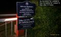
Foiled.
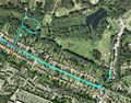
Google Earth Track


Achievements
Sourcerer earned the OpenStreetMap achievement
|
Expeditions and Plans
| 2016-06-10 | ||
|---|---|---|
| Pforzheim, Germany | RecentlyChanged | Near the school I worked, forest. |
| Norwich, United Kingdom | Sourcerer | A golf course point at Bixley Heath, Ipswich, Suffolk, UK. |
Sourcerer's Expedition Links
2016-06-09 52 0 - 2016-06-10 52 1 - 2016-06-11 52 1 - KML file download of Sourcerer's expeditions for use with Google Earth.