Difference between revisions of "2016-07-18 -35 149"
imported>1PE (→Photos) |
imported>FippeBot m (Location) |
||
| (One intermediate revision by one other user not shown) | |||
| Line 49: | Line 49: | ||
{{#vardefine:ribbonwidth|800px}} | {{#vardefine:ribbonwidth|800px}} | ||
<!-- Add any achievement ribbons you earned below, or remove this section --> | <!-- Add any achievement ribbons you earned below, or remove this section --> | ||
| − | |||
| − | |||
| − | |||
| − | |||
| − | |||
| − | |||
| − | |||
| − | |||
| − | |||
| − | |||
| − | |||
| − | |||
| − | |||
[[Category:Expeditions]] | [[Category:Expeditions]] | ||
| − | |||
| − | |||
[[Category:Expeditions with photos]] | [[Category:Expeditions with photos]] | ||
| − | |||
| − | |||
| − | |||
| − | |||
[[Category:Coordinates reached]] | [[Category:Coordinates reached]] | ||
| − | + | {{location|AU|ACT}} | |
| − | |||
| − | |||
| − | |||
| − | |||
| − | |||
| − | |||
| − | |||
| − | |||
| − | |||
| − | |||
| − | |||
| − | |||
| − | |||
| − | |||
| − | |||
| − | |||
| − | |||
Latest revision as of 01:02, 16 August 2019
| Mon 18 Jul 2016 in -35,149: -35.3543422, 149.1333489 geohashing.info google osm bing/os kml crox |
Location
Mugga Lane, within a construction site for roadworks, near the hard rock mine entrance south of Symonston Correctional Facility.
Participants
Plans
1PE
Go during lunchtime and find the tree where the hash is sited.
Expedition
1PE
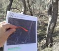
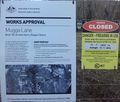
I went during lunchtime and found that there were two major construction sites, one at the Symonston Correctional Facility and another at the entrance road to the hard rock mine. I passed the temporary traffic lights at the road intersection, and parked under a large tree. Then, I worked out that the tree where the hash is sited was not where I'd parked; it was back within the traffic cone area. Fortunately, it was not within the actual construction site, so I was able to stand under the tree and take some pictures, much to the amusement of the workers and drivers along the road.


