Difference between revisions of "2016-08-04 49 8"
imported>DODO (→Location) |
imported>FippeBot m (Location) |
||
| (5 intermediate revisions by one other user not shown) | |||
| Line 25: | Line 25: | ||
<!-- who attended: If you link to your wiki user name in this section, your expedition will be picked up by the various statistics generated for geohashing. You may use three tildes ~ as a shortcut to automatically insert the user signature of the account you are editing with. | <!-- who attended: If you link to your wiki user name in this section, your expedition will be picked up by the various statistics generated for geohashing. You may use three tildes ~ as a shortcut to automatically insert the user signature of the account you are editing with. | ||
--> | --> | ||
| + | [[User:DODO|DODO]] | ||
== Plans == | == Plans == | ||
| Line 31: | Line 32: | ||
== Expedition == | == Expedition == | ||
<!-- how it all turned out. your narrative goes here. --> | <!-- how it all turned out. your narrative goes here. --> | ||
| + | There've been several hashes in the last days, that were close to my home, but I had no time for hashing, and by the way a remarkable amount of them seemed unreachable. But today was to easy not to go. It was just some 100 meters from my usual way to the office, and the detour to the hash was just 200 m longer than usual. | ||
| + | Not much to tell about it. Went there by bull, had to wait two or three minutes for a fps-signal and made some pictures in the hash-direction. Walked the remaining 20 m into the field, that was already harvested and now grown over by trefoil. Took some pictures, walked back to my bull and continued my way to work. | ||
== Tracklog == | == Tracklog == | ||
| Line 39: | Line 42: | ||
Image:2012-##-## ## ## Alpha.jpg | Witty Comment | Image:2012-##-## ## ## Alpha.jpg | Witty Comment | ||
--> | --> | ||
| − | <gallery perrow=" | + | <gallery perrow="6"> |
| + | Image:2016-08-04_49_8-1.jpg|the hashfield | ||
| + | Image:2016-08-04_49_8-2.jpg|with bull in the foreground | ||
| + | Image:2016-08-04_49_8-3.jpg|and vice versa, hash field with bull in the background | ||
| + | Image:2016-08-04_49_8-4.jpg|the former train-house seen from the hash | ||
| + | Image:2016-08-04_49_8-5.jpg|the hasher | ||
| + | Image:2016-08-04_49_8-6.png|proof | ||
</gallery> | </gallery> | ||
| Line 46: | Line 55: | ||
<!-- Add any achievement ribbons you earned below, or remove this section --> | <!-- Add any achievement ribbons you earned below, or remove this section --> | ||
| − | + | {{land geohash | |
| − | + | | latitude = 49 | |
| − | + | | longitude = 8 | |
| + | | date = 2016-08-04 | ||
| + | | name = DODO | ||
| + | }} | ||
| − | |||
| − | |||
| − | |||
| − | |||
| − | |||
| − | |||
| − | |||
| − | |||
| − | |||
| − | |||
[[Category:Expeditions]] | [[Category:Expeditions]] | ||
| − | |||
| − | |||
| − | |||
| − | |||
| − | |||
| − | |||
| − | |||
[[Category:Coordinates reached]] | [[Category:Coordinates reached]] | ||
| − | + | {{location|DE|BW|HD}} | |
| − | |||
| − | |||
| − | |||
| − | |||
| − | |||
| − | |||
| − | |||
| − | |||
| − | |||
| − | |||
| − | |||
| − | |||
| − | |||
| − | |||
| − | |||
| − | |||
| − | |||
Latest revision as of 01:09, 16 August 2019
| Thu 4 Aug 2016 in 49,8: 49.3230370, 8.4682522 geohashing.info google osm bing/os kml crox |
Location
A field next to the bridge of Speyer (on the right (and by that wrong) side.
Participants
Plans
Expedition
There've been several hashes in the last days, that were close to my home, but I had no time for hashing, and by the way a remarkable amount of them seemed unreachable. But today was to easy not to go. It was just some 100 meters from my usual way to the office, and the detour to the hash was just 200 m longer than usual. Not much to tell about it. Went there by bull, had to wait two or three minutes for a fps-signal and made some pictures in the hash-direction. Walked the remaining 20 m into the field, that was already harvested and now grown over by trefoil. Took some pictures, walked back to my bull and continued my way to work.
Tracklog
Photos
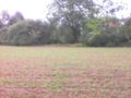
the hashfield
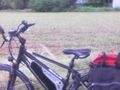
with bull in the foreground
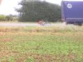
and vice versa, hash field with bull in the background
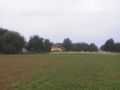
the former train-house seen from the hash

the hasher

proof


Achievements
DODO earned the Land geohash achievement
|