Difference between revisions of "2016-08-23 49 8"
From Geohashing
imported>DODO (→Tracklog) |
m (per Renaming Proposal) |
||
| (3 intermediate revisions by 2 users not shown) | |||
| Line 46: | Line 46: | ||
--> | --> | ||
<gallery perrow="5"> | <gallery perrow="5"> | ||
| + | Image:2016-08-23_49_8-1.jpg|unhappy hasher (stupid no grin) | ||
| + | Image:2016-08-23_49_8-2.jpg|dense kohlrabi (or some other cabbage) | ||
| + | Image:2016-08-23_49_8-3.jpg|proof of transport | ||
| + | Image:S2016-08-23_49_8-4.png|still 60 m to go. I made it down to 45m (without proof) | ||
</gallery> | </gallery> | ||
| Line 52: | Line 56: | ||
<!-- Add any achievement ribbons you earned below, or remove this section --> | <!-- Add any achievement ribbons you earned below, or remove this section --> | ||
| − | + | {{done with nature | |
| − | + | | latitude = 49 | |
| − | + | | longitude = 8 | |
| + | | date = 2016-08-23 | ||
| + | | name = DODO | ||
| + | | image = 2016-08-23_49_8-2.jpg | ||
| + | }} | ||
| − | |||
| − | |||
| − | |||
| − | |||
| − | |||
| − | |||
| − | |||
| − | |||
[[Category:Expeditions]] | [[Category:Expeditions]] | ||
| − | |||
| − | |||
| − | |||
| − | |||
| − | |||
| − | |||
| − | |||
| − | |||
| − | |||
| − | |||
| − | |||
[[Category:Coordinates not reached]] | [[Category:Coordinates not reached]] | ||
| − | |||
| − | |||
[[Category:Not reached - Mother Nature]] | [[Category:Not reached - Mother Nature]] | ||
| − | |||
| − | |||
[[Category:Not reached - No public access]] | [[Category:Not reached - No public access]] | ||
| − | + | {{location|DE|RP|RP}} | |
| − | |||
| − | |||
| − | |||
| − | |||
| − | |||
| − | |||
| − | |||
Latest revision as of 14:29, 2 April 2024
| Tue 23 Aug 2016 in 49,8: 49.3037776, 8.3919380 geohashing.info google osm bing/os kml crox |
Location
A kohlrabi-field between Dudenhofen and Römerberg.
Participants
Plans
To close not to try. I'll go therefore work.
Expedition
It is just 4 kilometers by bike, and so I ride there in the early morning before I go to work. I reached a very dense planted field with (maybe) kohlrabis. I didn't want to harm any plants and I didn't have the time to search for eventual tractor tracks.
I reached home again half an hour after I started.
Tracklog
Photos
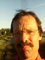
unhappy hasher (stupid no grin)
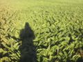
dense kohlrabi (or some other cabbage)
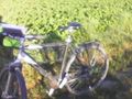
proof of transport
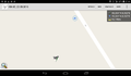
still 60 m to go. I made it down to 45m (without proof)


Achievements
DODO earned the Done with Nature consolation prize
|