Difference between revisions of "2016-10-27 49 8"
From Geohashing
imported>DODO (→Location) |
imported>FippeBot m (Location) |
||
| (7 intermediate revisions by one other user not shown) | |||
| Line 25: | Line 25: | ||
<!-- who attended: If you link to your wiki user name in this section, your expedition will be picked up by the various statistics generated for geohashing. You may use three tildes ~ as a shortcut to automatically insert the user signature of the account you are editing with. | <!-- who attended: If you link to your wiki user name in this section, your expedition will be picked up by the various statistics generated for geohashing. You may use three tildes ~ as a shortcut to automatically insert the user signature of the account you are editing with. | ||
--> | --> | ||
| + | [[User:DODO|DODO]] | ||
== Plans == | == Plans == | ||
<!-- what were the original plans --> | <!-- what were the original plans --> | ||
| + | To close not to go. Had to go to work by car, so I'll drive close and walk the rest. | ||
== Expedition == | == Expedition == | ||
<!-- how it all turned out. your narrative goes here. --> | <!-- how it all turned out. your narrative goes here. --> | ||
| + | Pretty much as planned. It was exactly 10 kilometers from where I left my way to work until I parked the car. From there it was just one kilometer of walking. The hash lied in a light forest with high wet gras. But I had only to walk into the gras for 10 meters. I took some photos, walked 1 kilometer back, drove 10 kilometers back to my way to work and that was it. | ||
== Tracklog == | == Tracklog == | ||
<!-- if your GPS device keeps a log, you may post a link here --> | <!-- if your GPS device keeps a log, you may post a link here --> | ||
| + | [https://www.komoot.de/tour/13240215 10 kilometers by car, 2 kilometers by foot]. I didn't record the last 10 kilometers by car (same way back). | ||
== Photos == | == Photos == | ||
| Line 39: | Line 43: | ||
Image:2012-##-## ## ## Alpha.jpg | Witty Comment | Image:2012-##-## ## ## Alpha.jpg | Witty Comment | ||
--> | --> | ||
| − | <gallery perrow=" | + | <gallery perrow="6"> |
| + | Image:2016-10-27_49_8-5.jpg|where (and why) I left my car | ||
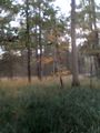
| + | Image:2016-10-27_49_8-1.jpg|view to the hash | ||
| + | Image:2016-10-27_49_8-6.png|proof | ||
| + | Image:2016-10-27_49_8-2.jpg|and from | ||
| + | Image:2016-10-27_49_8-4.jpg|and to another direction | ||
| + | Image:2016-10-27_49_8-3.jpg|and to the hasher | ||
</gallery> | </gallery> | ||
== Achievements == | == Achievements == | ||
| − | |||
| − | |||
| − | + | {{land geohash | |
| − | + | | latitude = 49 | |
| − | + | | longitude = 8 | |
| + | | date = 2016-10-27 | ||
| + | | name = DODO | ||
| + | }} | ||
| − | |||
| − | |||
| − | |||
| − | |||
| − | |||
| − | |||
| − | |||
| − | |||
| − | |||
| − | |||
[[Category:Expeditions]] | [[Category:Expeditions]] | ||
| − | |||
| − | |||
| − | |||
| − | |||
| − | |||
| − | |||
| − | |||
[[Category:Coordinates reached]] | [[Category:Coordinates reached]] | ||
| − | + | {{location|DE|RP|RP}} | |
| − | |||
| − | |||
| − | |||
| − | |||
| − | |||
| − | |||
| − | |||
| − | |||
| − | |||
| − | |||
| − | |||
| − | |||
| − | |||
| − | |||
| − | |||
| − | |||
| − | |||
Latest revision as of 01:39, 16 August 2019
| Thu 27 Oct 2016 in 49,8: 49.3452033, 8.3401714 geohashing.info google osm bing/os kml crox |
Location
In the forest near Iggelheim.
Participants
Plans
To close not to go. Had to go to work by car, so I'll drive close and walk the rest.
Expedition
Pretty much as planned. It was exactly 10 kilometers from where I left my way to work until I parked the car. From there it was just one kilometer of walking. The hash lied in a light forest with high wet gras. But I had only to walk into the gras for 10 meters. I took some photos, walked 1 kilometer back, drove 10 kilometers back to my way to work and that was it.
Tracklog
10 kilometers by car, 2 kilometers by foot. I didn't record the last 10 kilometers by car (same way back).
Photos
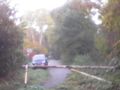
where (and why) I left my car
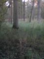
view to the hash
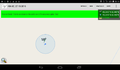
proof
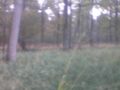
and from
and to another direction
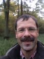
and to the hasher


Achievements
DODO earned the Land geohash achievement
|