Difference between revisions of "2016-12-12 49 8"
imported>DODO (→Photos) |
imported>FippeBot m (Location) |
||
| (3 intermediate revisions by one other user not shown) | |||
| Line 39: | Line 39: | ||
--> | --> | ||
<gallery perrow="5"> | <gallery perrow="5"> | ||
| + | Image:2016-12-12_49_8-1.jpg|I left my bull at the edge of... | ||
| + | Image:2016-12-12_49_8-2.jpg|...the hash field. You can see the Autobahn (B9) in the background | ||
| + | Image:2016-12-12_49_8-6.png|proof | ||
| + | Image:2016-12-12_49_8-3.jpg|From the hash back to the bull | ||
| + | Image:2016-12-12_49_8-4.jpg|forward to the autobahn | ||
| + | Image:2016-12-12_49_8-5.jpg|And where I came from | ||
| + | Image:2016-12-12_49_8-7.jpg|and me with stupid grin | ||
</gallery> | </gallery> | ||
| − | |||
== Achievements == | == Achievements == | ||
{{#vardefine:ribbonwidth|800px}} | {{#vardefine:ribbonwidth|800px}} | ||
| − | + | {{land geohash | |
| + | | latitude = 49 | ||
| + | | longitude = 8 | ||
| + | | date = 2016-12-12 | ||
| + | | name = DODO | ||
| + | }} | ||
| − | + | {{Sunrise geohash | |
| − | + | | latitude = 49 | |
| − | + | | longitude = 8 | |
| + | | date = 2016-12-12 | ||
| + | | name = DODO | ||
| + | }} | ||
| − | + | {{Template:Tron | |
| − | + | | latitude = 49 | |
| − | + | | longitude = 8 | |
| − | + | | date = 2016-12-12 | |
| − | + | | name = DODO | |
| − | + | | possessive = his | |
| − | + | | tracklog = https://www.komoot.de/tour/13676873 | |
| − | + | }} | |
| + | [[Category:Expeditions]] | ||
| − | |||
| − | |||
| − | |||
| − | |||
| − | |||
| − | |||
| − | |||
| − | |||
| − | |||
[[Category:Coordinates reached]] | [[Category:Coordinates reached]] | ||
| − | + | {{location|DE|RP|RP}} | |
| − | |||
| − | |||
| − | |||
| − | |||
| − | |||
| − | |||
| − | |||
| − | |||
| − | |||
| − | |||
| − | |||
| − | |||
| − | |||
| − | |||
| − | |||
| − | |||
| − | |||
Latest revision as of 01:51, 16 August 2019
| Mon 12 Dec 2016 in 49,8: 49.3955192, 8.4174704 geohashing.info google osm bing/os kml crox |
Location
A field near Waldsee
Participants
Plans
Go there by bull in the morning on my way to the office.
Expedition
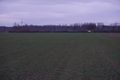
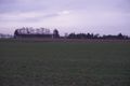
I had no successful hash for ... years? No, it was just 45 days. But that's nevertheless the longest time without hashing since I started in 2013. So I got really excited, when I checked the hashes on Saturday morning. All three of them (Sa, Su and Mo) were in a short distance and looked reachable. Well, I was to busy on saturday and wasn't successful yesterday, so I just had to go today. I decided to try it in the morning on my way to the office - that would be just a detour of 10 kilometers. It was still dark when I started, but it became clearer during the ride and so I could take some pictures when I reached the hashfield. I had to walk into the field for 60 meters. It was drizzling all morning and the field was wet and muddy. But I reached the wanted position at 8 o'clock. As you can see here the sun rises at the hash at 8:11 on 2016-12-12 so I think, that even qualifies for a sunrise-achievement, although I wasn't able to see the sun (or even locate it) at all. I quickly continued my way to the office, used the - meanwhile well known - ferry and reached the office at half past eight. As a bonus, I didn't cross my usual way to the office on the way, and so I was able to achieve a tron also.
Tracklog
Photos
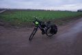
I left my bull at the edge of...
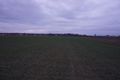
...the hash field. You can see the Autobahn (B9) in the background
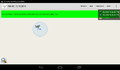
proof
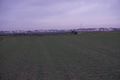
From the hash back to the bull
forward to the autobahn
And where I came from

and me with stupid grin


Achievements
DODO earned the Land geohash achievement
|
DODO earned the Sunrise Geohash Achievement
|
DODO earned the Tron achievement
|