Difference between revisions of "2017-01-23 47 8"
imported>ThreeFx (Created page with "{{subst:Expedition |lat = 47 |lon = 8 |date = 2017-01-23 }}") |
imported>FippeBot m (Location) |
||
| (12 intermediate revisions by 2 users not shown) | |||
| Line 20: | Line 20: | ||
== Location == | == Location == | ||
<!-- where you've surveyed the hash to be --> | <!-- where you've surveyed the hash to be --> | ||
| + | Next to one of the main roads near Affoltern. | ||
== Participants == | == Participants == | ||
<!-- who attended: If you link to your wiki user name in this section, your expedition will be picked up by the various statistics generated for geohashing. You may use three tildes ~ as a shortcut to automatically insert the user signature of the account you are editing with. | <!-- who attended: If you link to your wiki user name in this section, your expedition will be picked up by the various statistics generated for geohashing. You may use three tildes ~ as a shortcut to automatically insert the user signature of the account you are editing with. | ||
--> | --> | ||
| + | *[[user:ThreeFx|ThreeFx]] | ||
== Plans == | == Plans == | ||
<!-- what were the original plans --> | <!-- what were the original plans --> | ||
| + | This was fairly spontaneous. At about 15:45 I decided to check today's hash and lo and behold, it's right next to the Hönggerberg, where a part of the ETH is located. 10 minutes later I was in the bus on my way to Höngg. | ||
== Expedition == | == Expedition == | ||
<!-- how it all turned out. your narrative goes here. --> | <!-- how it all turned out. your narrative goes here. --> | ||
| + | The only thing I didn't check was my phone's battery, which was fairly empty already. But still, I arrived on the Hönggerberg at half past 4 and managed to walk straight down to the hash without my phone dying. After I took the photos, I walked back to the Hönggerberg without experiencing any difficulties - except the icy weather, against which I brought my jacket with me. | ||
== Tracklog == | == Tracklog == | ||
<!-- if your GPS device keeps a log, you may post a link here --> | <!-- if your GPS device keeps a log, you may post a link here --> | ||
| + | [[Image:2017-01-23_47_08-tracklog.png]] | ||
== Photos == | == Photos == | ||
| Line 39: | Line 44: | ||
--> | --> | ||
<gallery perrow="5"> | <gallery perrow="5"> | ||
| + | {{#vardefine:gaWidth|150}} | ||
| + | {{#vardefine:gaHeight|127}} | ||
| + | {{#vardefine:gaLines|2}} | ||
| + | Image:2017-01-23_47_8-proof.png | [[User:ThreeFx|ThreeFx]]'s almost empty phone with the coordinates. | ||
| + | Image:2017-01-23_47_08-threefx.jpg | [[User:ThreeFx|ThreeFx]] at the hash. | ||
| + | Image:2017-01-23_47_08-hash.jpg | The hash itself, located almost exactly on this street corner. | ||
| + | Image:2017-01-23_47_08-snowy.jpg | Switzerland's snowy landscape, passed en route to the hash. | ||
</gallery> | </gallery> | ||
| Line 44: | Line 56: | ||
{{#vardefine:ribbonwidth|800px}} | {{#vardefine:ribbonwidth|800px}} | ||
<!-- Add any achievement ribbons you earned below, or remove this section --> | <!-- Add any achievement ribbons you earned below, or remove this section --> | ||
| + | |||
| + | {{Frozen Geohash | ||
| + | | latitude = 47 | ||
| + | | longitude = 8 | ||
| + | | date = 2017-01-23 | ||
| + | | temperature = -4°C | ||
| + | | name = ThreeFx | ||
| + | | image = 2017-01-23_47_8-proof.png | ||
| + | }} | ||
<!-- =============== USEFUL CATEGORIES FOLLOW ================ | <!-- =============== USEFUL CATEGORIES FOLLOW ================ | ||
Delete the next line ONLY if you have chosen the appropriate categories below. If you are unsure, don't worry. People will read your report and help you with the classification. --> | Delete the next line ONLY if you have chosen the appropriate categories below. If you are unsure, don't worry. People will read your report and help you with the classification. --> | ||
| − | |||
<!-- ==REQUEST FOR TWITTER BOT== Please leave either the New report or the Expedition planning category in as long as you work on it. This helps the twitter bot a lot with announcing the right outcome at the right moment. --> | <!-- ==REQUEST FOR TWITTER BOT== Please leave either the New report or the Expedition planning category in as long as you work on it. This helps the twitter bot a lot with announcing the right outcome at the right moment. --> | ||
| − | |||
| − | |||
| − | |||
| − | |||
| − | |||
| − | |||
| − | |||
[[Category:Expeditions]] | [[Category:Expeditions]] | ||
| − | |||
[[Category:Expeditions with photos]] | [[Category:Expeditions with photos]] | ||
| − | |||
| − | |||
| − | |||
| − | |||
| − | |||
[[Category:Coordinates reached]] | [[Category:Coordinates reached]] | ||
| − | + | {{location|CH|ZH}} | |
| − | |||
| − | |||
| − | |||
| − | |||
| − | |||
| − | |||
| − | |||
| − | |||
| − | |||
| − | |||
| − | |||
| − | |||
| − | |||
| − | |||
| − | |||
| − | |||
| − | |||
Latest revision as of 02:20, 7 August 2019
| Mon 23 Jan 2017 in 47,8: 47.4163709, 8.5065222 geohashing.info google osm bing/os kml crox |
Location
Next to one of the main roads near Affoltern.
Participants
Plans
This was fairly spontaneous. At about 15:45 I decided to check today's hash and lo and behold, it's right next to the Hönggerberg, where a part of the ETH is located. 10 minutes later I was in the bus on my way to Höngg.
Expedition
The only thing I didn't check was my phone's battery, which was fairly empty already. But still, I arrived on the Hönggerberg at half past 4 and managed to walk straight down to the hash without my phone dying. After I took the photos, I walked back to the Hönggerberg without experiencing any difficulties - except the icy weather, against which I brought my jacket with me.
Tracklog

Photos
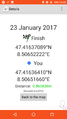
ThreeFx's almost empty phone with the coordinates.

ThreeFx at the hash.
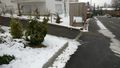
The hash itself, located almost exactly on this street corner.
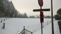
Switzerland's snowy landscape, passed en route to the hash.


Achievements
ThreeFx earned the Frozen Geohash Achievement
|