Difference between revisions of "2017-02-04 53 8"
From Geohashing
imported>Kerko |
imported>FippeBot m (Location) |
||
| Line 32: | Line 32: | ||
[[Category:Expedition without GPS]] | [[Category:Expedition without GPS]] | ||
[[Category:Coordinates reached]] | [[Category:Coordinates reached]] | ||
| + | {{location|DE|NI|OL}} | ||
Latest revision as of 02:06, 16 August 2019
| Sat 4 Feb 2017 in 53,8: 53.1150716, 8.4439616 geohashing.info google osm bing/os kml crox |
Location
A field with many molehills near Hude.
Participants
Plans
Because this geohash wasn’t too far, I tried to reach it by bike.
Expedition
I rode to Hude by bike directly and on the way back home I visited the geohash at 4:00 PM. To prove the location I made a picture with some street signs, although there is an error of a few hundred metres. For more accuracy I used STUPIDMAP, which needs no GPS. It shows the correct position, but only when it is at the correct position. On the further way I had made some pictures in the forest Reiherholz, until the camera’s battery was dead. Proof of date: Upload time of pictures.
Photos
Some street signs and the railway crossing near Hude.
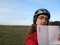
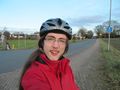
Me and a molehill at the geohash.
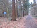
Who needs this footpath?
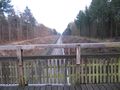
The geohash is already out of sight.


