Difference between revisions of "2017-02-18 49 8"
imported>Rincewind (An expedition message sent via Geohash Droid for Android.) |
imported>FippeBot m (Location) |
||
| (13 intermediate revisions by 3 users not shown) | |||
| Line 19: | Line 19: | ||
== Location == | == Location == | ||
| − | + | A mere 2.8km as the bird flies (and 5km as the car drives...) next to federal road B3. | |
| + | Can't not go. :) | ||
== Participants == | == Participants == | ||
<!-- who attended: If you link to your wiki user name in this section, your expedition will be picked up by the various statistics generated for geohashing. You may use three tildes ~ as a shortcut to automatically insert the user signature of the account you are editing with. | <!-- who attended: If you link to your wiki user name in this section, your expedition will be picked up by the various statistics generated for geohashing. You may use three tildes ~ as a shortcut to automatically insert the user signature of the account you are editing with. | ||
--> | --> | ||
| − | + | [[User:Rincewind|Rincewind]] and [[User:Yakamoz|Yakamoz]] | |
| − | |||
| − | |||
== Expedition == | == Expedition == | ||
<!-- how it all turned out. your narrative goes here. --> | <!-- how it all turned out. your narrative goes here. --> | ||
| − | + | When Yakamoz came home, we left for the expedition. A couple minutes of driving later, we found that we were lucky- Rincewind had misjudged the coordinates to be to the right side of the road, which would have been military area and fenced off. | |
| − | + | <p> | |
| − | + | It was to the left, though and we just had to park the car on the side of the road bank and walk less than a hundred meters. After fighting through a bit of thorns, we could walk straight to the coordinates in the woods. The GPS gadget easily counted down the distance and we didn't even have to do a hash dance. | |
| + | Unfortunately, Rincewind forgot the camera (spell: mobile phone) in the car and so we don't have a hashsite photo- just imagine a fairly standard Pine forest. All in all, a very easy hash and door to door less than thirty minutes, I guess. :) | ||
| + | <br><br>Q-Owl: So near, but not enough time today. :( | ||
== Photos == | == Photos == | ||
| Line 39: | Line 40: | ||
--> | --> | ||
<gallery perrow="5"> | <gallery perrow="5"> | ||
| + | Image:2017-02-18 49 8 hashproof.jpg|GPS doodad screenshot | ||
| + | Image:2017-02-18 49 8 hashgrin.jpg|Stupid grin(TM) | ||
| + | Image:2017-02-18_49_8_Rincewind_1487438488544.jpg|Distance from parking spot | ||
</gallery> | </gallery> | ||
| Line 44: | Line 48: | ||
{{#vardefine:ribbonwidth|800px}} | {{#vardefine:ribbonwidth|800px}} | ||
<!-- Add any achievement ribbons you earned below, or remove this section --> | <!-- Add any achievement ribbons you earned below, or remove this section --> | ||
| + | "Land" and "Easy" would apply, if I wasn't too lazy. :) | ||
| − | + | [[Category:Expeditions]] | |
| − | |||
| − | |||
| − | |||
| − | |||
| − | |||
| − | |||
| − | |||
| − | |||
| − | |||
| − | |||
| − | |||
| − | |||
| − | |||
| − | [[Category:Expeditions]] | ||
| − | |||
[[Category:Expeditions with photos]] | [[Category:Expeditions with photos]] | ||
| − | |||
| − | |||
| − | |||
| − | |||
| − | |||
[[Category:Coordinates reached]] | [[Category:Coordinates reached]] | ||
| − | + | {{location|DE|HE|DA}} | |
| − | |||
| − | |||
| − | |||
| − | |||
| − | |||
| − | |||
| − | |||
| − | |||
| − | |||
| − | |||
| − | |||
| − | |||
| − | |||
| − | |||
| − | |||
| − | |||
| − | |||
Latest revision as of 18:22, 26 July 2019
| Sat 18 Feb 2017 in 49,8: 49.7858425, 8.6326259 geohashing.info google osm bing/os kml crox |
Location
A mere 2.8km as the bird flies (and 5km as the car drives...) next to federal road B3. Can't not go. :)
Participants
Expedition
When Yakamoz came home, we left for the expedition. A couple minutes of driving later, we found that we were lucky- Rincewind had misjudged the coordinates to be to the right side of the road, which would have been military area and fenced off.
It was to the left, though and we just had to park the car on the side of the road bank and walk less than a hundred meters. After fighting through a bit of thorns, we could walk straight to the coordinates in the woods. The GPS gadget easily counted down the distance and we didn't even have to do a hash dance.
Unfortunately, Rincewind forgot the camera (spell: mobile phone) in the car and so we don't have a hashsite photo- just imagine a fairly standard Pine forest. All in all, a very easy hash and door to door less than thirty minutes, I guess. :)
Q-Owl: So near, but not enough time today. :(
Photos
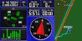
GPS doodad screenshot

Stupid grin(TM)

Distance from parking spot


Achievements
"Land" and "Easy" would apply, if I wasn't too lazy. :)