Difference between revisions of "2017-03-02 42 -78"
imported>Pedalpusher (new report; summary, ribbons added) |
imported>FippeBot m (Location) |
||
| (2 intermediate revisions by one other user not shown) | |||
| Line 14: | Line 14: | ||
== Photos == | == Photos == | ||
<gallery perrow="7"> | <gallery perrow="7"> | ||
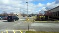
| − | Image: | + | Image: 2017-03-02 hashView.jpg | A view of the hash from the parking spot. |
| − | Image: | + | Image: 2017-03-02 android.png | Made it! |
| − | Image: | + | Image: 2017-03-02 building.jpg | A view of the building from the hash. |
| − | Image: | + | Image: 2017-03-02 hashCar.jpg | A view of the hash-mobile from the hash. |
| − | Image: | + | Image: 2017-03-02 streetView.jpg | A view of the main road from the hash. |
| − | Image: | + | Image: 2017-03-02 stupidGrin.jpg | The picture at the hash was really bad so I took a less terrible picture in the car. |
| − | Image: | + | Image: 2017-03-02 frozen.jpg | Forgot about the Frozen hash while I was there, but from the weather report it shows it is below 30°F and I think this counts. |
| − | |||
</gallery> | </gallery> | ||
| Line 29: | Line 28: | ||
| longitude = -78 | | longitude = -78 | ||
| date = 2017-03-02 | | date = 2017-03-02 | ||
| + | }} | ||
| + | {{Frozen Geohash | ||
| + | | latitude = 42 | ||
| + | | longitude = -78 | ||
| + | | date = 2017-03-02 | ||
| + | | name = Pedalpusher | ||
| + | | temperature = 28 °F | ||
}} | }} | ||
| − | |||
[[Category:Expeditions]] | [[Category:Expeditions]] | ||
[[Category:Coordinates reached]] | [[Category:Coordinates reached]] | ||
| − | + | [[Category:Expeditions with photos]] | |
| + | {{location|US|NY|ER}} | ||
Latest revision as of 02:11, 16 August 2019
| Thu 2 Mar 2017 in 42,-78: 42.8018075, -78.7544979 geohashing.info google osm bing/os kml crox |
Location
In the parking lot of Southtowns Radiology in Orchard Park
Participants
Expedition
Knowing I was going to be in Cheektowaga this morning, I thought it would be an easy detour on the way home. After getting out of the luncheon, I checked my map and had simple directions to follow to get to Rt 240 in Orchard Park.
Finding the building and parking lot, I pulled in and found an open spot right next to the grassy area where the hash landed for today. I hopped out of the car and easily made my way to the spot with minimal GPS dancing. When I was looking at the google map before I left, I thought I had been there before at a place called Quest Diagnostics which is a medical lab. I needed to give some blood for a few tests. Today, when I arrived, I didn't see the sign for Quest, but there were big white construction trucks and it looked like the sign above the door had been removed. It appears the lab has moved. I don't have proof of my visit because at that time, the doctor's office screwed up the lab work prescription so I didn't get a receipt for being there that day. I did drive by that spot, although I didn't walk on the grass for a true Deja Vu.
Photos
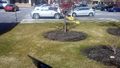
A view of the hash from the parking spot.
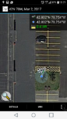
Made it!
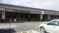
A view of the building from the hash.
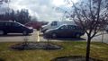
A view of the hash-mobile from the hash.
A view of the main road from the hash.
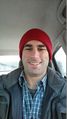
The picture at the hash was really bad so I took a less terrible picture in the car.
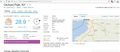
Forgot about the Frozen hash while I was there, but from the weather report it shows it is below 30°F and I think this counts.


Ribbons
This user earned the Land geohash achievement
|
