Difference between revisions of "2017-03-03 52 5"
imported>FelixTheCat (Created page with "{{subst:Expedition |lat = 52 |lon = 5 |date = 2017-03-03 }}") |
imported>FippeBot m (Location) |
||
| (One intermediate revision by one other user not shown) | |||
| Line 1: | Line 1: | ||
| − | |||
| − | |||
| − | |||
| − | |||
| − | |||
| − | |||
| − | |||
| − | |||
| − | |||
| − | |||
{{meetup graticule | {{meetup graticule | ||
| lat=52 | | lat=52 | ||
| Line 14: | Line 4: | ||
| date=2017-03-03 | | date=2017-03-03 | ||
}} | }} | ||
| − | |||
| − | |||
__NOTOC__ | __NOTOC__ | ||
| − | |||
== Location == | == Location == | ||
| − | + | Veluwezoom National Park, Rheden. | |
== Participants == | == Participants == | ||
| − | + | [[User:FelixTheCat|FelixTheCat]] ([[User talk:FelixTheCat|talk]]) | |
| − | |||
| − | == | + | == Expedition == |
| − | + | I had to go to Nijmegen for work today, so this hash was pretty close by. I was planning to stop by on my way back home, hopefully before dark. Unfortunately work took until 17:30, and with the hash being about 30 minutes away it would be tricky. | |
| − | + | Veluwezoom NP is quite a large and empty area, but there are a few narrow, winding roads leading inside. I drove as close to the hash as possible and parked the hashmobile. I then followed my GPS to a spot pretty close by in an area covered with thorny bushes, which made my GPS dance very uncomfortable. Only after recording a "success" did I realise that I wasn't at the hashpoint at all; my GPS had picked a different point from random keystrokes it received when it bounced around in my pocket! The actual hash point was about 800 metres away, so I started running to make it before sunset. | |
| − | |||
| − | + | The hash turned out to be in a wide open area, which must be very pretty and pleasant when it's sunny and dry. During evening twilight in early March, with thick cloud cover and drizzle setting in, not so much. I quickly took some pictures and then hurried back to my car and went home. | |
| − | |||
== Photos == | == Photos == | ||
| − | |||
| − | |||
| − | |||
<gallery perrow="5"> | <gallery perrow="5"> | ||
| + | Image:2017-03-03 52 5 FelixTheCat 1.jpg | The little car park at the end of the road. | ||
| + | Image:2017-03-03 52 5 FelixTheCat 2.jpg | The thorny bushes where the hashpoint was ''not'' located. | ||
| + | Image:2017-03-03 52 5 FelixTheCat 3.jpg | This imposing structure is called a "fire tower", so I guess it's used to watch for fires. | ||
| + | Image:2017-03-03 52 5 FelixTheCat 4.jpg | Beautiful wide open landscape with rain coming in. | ||
| + | Image:2017-03-03 52 5 FelixTheCat 5.jpg | The hashpoint is somewhere around here. | ||
| + | Image:2017-03-03 52 5 FelixTheCat 6.png | Zero readings are somewhat easier to get in wide open spaces like this. | ||
| + | Image:2017-03-03 52 5 FelixTheCat 7.jpg | Lloyd posing at the hash. | ||
</gallery> | </gallery> | ||
== Achievements == | == Achievements == | ||
| + | {{land geohash | ||
| + | | latitude = 52 | ||
| + | | longitude = 5 | ||
| + | | date = 2017-03-03 | ||
| + | | name = [[User:FelixTheCat|FelixTheCat]] ([[User talk:FelixTheCat|talk]]) | ||
| + | }} | ||
{{#vardefine:ribbonwidth|800px}} | {{#vardefine:ribbonwidth|800px}} | ||
| − | |||
| − | |||
| − | |||
| − | |||
| − | |||
| − | |||
| − | |||
| − | |||
| − | |||
| − | |||
| − | |||
| − | |||
| − | |||
| − | |||
| − | |||
| − | |||
[[Category:Expeditions]] | [[Category:Expeditions]] | ||
| − | |||
[[Category:Expeditions with photos]] | [[Category:Expeditions with photos]] | ||
| − | |||
| − | |||
| − | |||
| − | |||
| − | |||
[[Category:Coordinates reached]] | [[Category:Coordinates reached]] | ||
| − | + | {{location|NL|GE}} | |
| − | |||
| − | |||
| − | |||
| − | |||
| − | |||
| − | |||
| − | |||
| − | |||
| − | |||
| − | |||
| − | |||
| − | |||
| − | |||
| − | |||
| − | |||
| − | |||
| − | |||
Latest revision as of 02:12, 16 August 2019
| Fri 3 Mar 2017 in 52,5: 52.0410716, 5.9793390 geohashing.info google osm bing/os kml crox |
Location
Veluwezoom National Park, Rheden.
Participants
Expedition
I had to go to Nijmegen for work today, so this hash was pretty close by. I was planning to stop by on my way back home, hopefully before dark. Unfortunately work took until 17:30, and with the hash being about 30 minutes away it would be tricky.
Veluwezoom NP is quite a large and empty area, but there are a few narrow, winding roads leading inside. I drove as close to the hash as possible and parked the hashmobile. I then followed my GPS to a spot pretty close by in an area covered with thorny bushes, which made my GPS dance very uncomfortable. Only after recording a "success" did I realise that I wasn't at the hashpoint at all; my GPS had picked a different point from random keystrokes it received when it bounced around in my pocket! The actual hash point was about 800 metres away, so I started running to make it before sunset.
The hash turned out to be in a wide open area, which must be very pretty and pleasant when it's sunny and dry. During evening twilight in early March, with thick cloud cover and drizzle setting in, not so much. I quickly took some pictures and then hurried back to my car and went home.
Photos
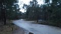
The little car park at the end of the road.
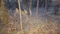
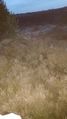
The thorny bushes where the hashpoint was not located.
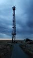
This imposing structure is called a "fire tower", so I guess it's used to watch for fires.
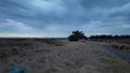
Beautiful wide open landscape with rain coming in.
The hashpoint is somewhere around here.
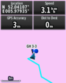
Zero readings are somewhat easier to get in wide open spaces like this.
Lloyd posing at the hash.


Achievements
FelixTheCat (talk) earned the Land geohash achievement
|