Difference between revisions of "2017-03-27 49 8"
From Geohashing
imported>DODO (Created page with "{{subst:Expedition |lat = 49 |lon = 8 |date = 2017-03-27 }}") |
imported>FippeBot m (Location) |
||
| (3 intermediate revisions by one other user not shown) | |||
| Line 20: | Line 20: | ||
== Location == | == Location == | ||
<!-- where you've surveyed the hash to be --> | <!-- where you've surveyed the hash to be --> | ||
| + | In the forest next to Dudenhofen, 3.6 KM from home (and less than 1 KM from [2017-03-23_49_8]) | ||
== Participants == | == Participants == | ||
<!-- who attended: If you link to your wiki user name in this section, your expedition will be picked up by the various statistics generated for geohashing. You may use three tildes ~ as a shortcut to automatically insert the user signature of the account you are editing with. | <!-- who attended: If you link to your wiki user name in this section, your expedition will be picked up by the various statistics generated for geohashing. You may use three tildes ~ as a shortcut to automatically insert the user signature of the account you are editing with. | ||
--> | --> | ||
| + | [[User:DODO|DODO]] | ||
== Plans == | == Plans == | ||
<!-- what were the original plans --> | <!-- what were the original plans --> | ||
| − | + | I saw this hash on friday, but forgot about it as to many things happened at the last weekend. So I was quit surprised, when I looked out for tomorrow's hash and found todays hash so close. | |
== Expedition == | == Expedition == | ||
<!-- how it all turned out. your narrative goes here. --> | <!-- how it all turned out. your narrative goes here. --> | ||
| + | It was already 6 pm but I decided to walk there anyway. It was a 9.5 KM walk, that took me 1 1/2 hour. I found a tron route with little effort. Unfortunately the battery was to low to log the last part of the walk, so you have to believe me that I took Sophie-de-la-Roche-Straße and Dudenhofer Straße and finished the tron. | ||
== Tracklog == | == Tracklog == | ||
<!-- if your GPS device keeps a log, you may post a link here --> | <!-- if your GPS device keeps a log, you may post a link here --> | ||
| + | [https://www.komoot.de/tour/14991025 8,6 KM ]from the 9,5 KM walk. | ||
== Photos == | == Photos == | ||
| Line 39: | Line 43: | ||
--> | --> | ||
<gallery perrow="5"> | <gallery perrow="5"> | ||
| + | Image:2017-03-27_49_8-4.png|proof | ||
| + | Image:2017-03-27_49_8-1.jpg|forest. Pretty much the same in all 4 directions | ||
| + | Image:2017-03-27_49_8-2.jpg|happy hasher | ||
| + | Image:2017-03-27_49_8-3.jpg|an X at the hash | ||
</gallery> | </gallery> | ||
| Line 45: | Line 53: | ||
<!-- Add any achievement ribbons you earned below, or remove this section --> | <!-- Add any achievement ribbons you earned below, or remove this section --> | ||
| − | + | {{land geohash | |
| − | + | | latitude = 49 | |
| − | + | | longitude = 8 | |
| + | | date = 2017-03-27 | ||
| + | | name = DODO | ||
| + | }} | ||
| − | + | {{Template:Tron | |
| + | | latitude = 49 | ||
| + | | longitude = 8 | ||
| + | | date = 2017-03-27 | ||
| + | | name = DODO | ||
| + | | tracklog = https://www.komoot.de/tour/14991025 | ||
| + | | possessive = his | ||
| + | }} | ||
| − | + | {{Walk geohash | |
| − | + | | latitude = 49 | |
| − | + | | longitude = 8 | |
| − | + | | date = 2017-03-27 | |
| + | | name = DODO | ||
| + | | distance = 9 KM | ||
| + | }} | ||
| − | |||
| − | |||
[[Category:Expeditions]] | [[Category:Expeditions]] | ||
| − | |||
[[Category:Expeditions with photos]] | [[Category:Expeditions with photos]] | ||
| − | |||
| − | |||
| − | |||
| − | |||
| − | |||
[[Category:Coordinates reached]] | [[Category:Coordinates reached]] | ||
| − | + | {{location|DE|RP|RP}} | |
| − | |||
| − | |||
| − | |||
| − | |||
| − | |||
| − | |||
| − | |||
| − | |||
| − | |||
| − | |||
| − | |||
| − | |||
| − | |||
| − | |||
| − | |||
| − | |||
| − | |||
Latest revision as of 02:19, 16 August 2019
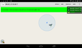
| Mon 27 Mar 2017 in 49,8: 49.3363591, 8.3773367 geohashing.info google osm bing/os kml crox |
Location
In the forest next to Dudenhofen, 3.6 KM from home (and less than 1 KM from [2017-03-23_49_8])
Participants
Plans
I saw this hash on friday, but forgot about it as to many things happened at the last weekend. So I was quit surprised, when I looked out for tomorrow's hash and found todays hash so close.
Expedition
It was already 6 pm but I decided to walk there anyway. It was a 9.5 KM walk, that took me 1 1/2 hour. I found a tron route with little effort. Unfortunately the battery was to low to log the last part of the walk, so you have to believe me that I took Sophie-de-la-Roche-Straße and Dudenhofer Straße and finished the tron.
Tracklog
8,6 KM from the 9,5 KM walk.
Photos
proof
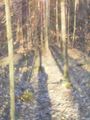
forest. Pretty much the same in all 4 directions

happy hasher
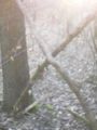
an X at the hash


Achievements
DODO earned the Land geohash achievement
|
DODO earned the Tron achievement
|
DODO earned the Walk geohash Achievement
|