Difference between revisions of "2017-04-14 49 7"
imported>DODO (Created page with "{{subst:Expedition |lat = 49 |lon = 7 |date = 2017-04-14 }}") |
imported>FippeBot m (Location) |
||
| (4 intermediate revisions by one other user not shown) | |||
| Line 20: | Line 20: | ||
== Location == | == Location == | ||
<!-- where you've surveyed the hash to be --> | <!-- where you've surveyed the hash to be --> | ||
| + | Deep in the palatine forest near Hermersbergerhof. | ||
== Participants == | == Participants == | ||
<!-- who attended: If you link to your wiki user name in this section, your expedition will be picked up by the various statistics generated for geohashing. You may use three tildes ~ as a shortcut to automatically insert the user signature of the account you are editing with. | <!-- who attended: If you link to your wiki user name in this section, your expedition will be picked up by the various statistics generated for geohashing. You may use three tildes ~ as a shortcut to automatically insert the user signature of the account you are editing with. | ||
--> | --> | ||
| + | [[User:DODO|DODO]] | ||
== Plans == | == Plans == | ||
<!-- what were the original plans --> | <!-- what were the original plans --> | ||
| + | I will go there by bull. I strt at 13:30. ETA 16:00. Would be so nice, if anyone else would be there. | ||
== Expedition == | == Expedition == | ||
<!-- how it all turned out. your narrative goes here. --> | <!-- how it all turned out. your narrative goes here. --> | ||
| + | It should be a 50 KM ride one way, but to make things more difficult I decided not to take the same way back and planned another way there. This way was going via St. Martin and had to cross two hills, both more than 500 m high. I knew this would be hard for both of us - my bull and me. After 25 KM of riding I reached the first hill and the climbing went surprisingly smooth, the street was good and the bull worked great. On the way down it could recuperat. But soon the second hill started, and just before it gets steep, the street ended and a forest path begun. This one was much more exhausting, but finally I reached the top. And here the hardest part begun. The path was now a very steep gravel way, I didn't dare to ride more than a 7 KM /h speed and my arms and hands were aching from the brakes. But this part also ended and I reached a wide street now. Short time later I had to leave that street to get to the hash. I could ride another kilometer, but then I had to take a very narrow and steep path upwards. So I left the bull in the valley and climbed upwards. After almost 1,5 KM I reached the top of the hill, 150 m higher than my bull and soon I found the hash there in the middle of the forest, some meters next to a path. I didn't have to build an X because someone else had already done so. Another ninya? | ||
| + | |||
| + | I walked back down to my bull and continued my ride. I had a short break in Annweiler for a squishy and an icecream. On my way back home I picked some lilac. 3 KM before I reached home, my tablet ran out of energy, so the last part of the trip is missing on the tracklog. But it is pretty clear how it worked. | ||
== Tracklog == | == Tracklog == | ||
<!-- if your GPS device keeps a log, you may post a link here --> | <!-- if your GPS device keeps a log, you may post a link here --> | ||
| + | [https://www.komoot.de/tour/15573254 111 km of bullriding and 3 KM walking (up and down)] | ||
== Photos == | == Photos == | ||
| Line 38: | Line 45: | ||
Image:2012-##-## ## ## Alpha.jpg | Witty Comment | Image:2012-##-## ## ## Alpha.jpg | Witty Comment | ||
--> | --> | ||
| − | <gallery perrow=" | + | <gallery perrow="6"> |
| + | Image:2017-04-14_49_7-1.jpg|I'll have to climb two of these | ||
| + | Image:2017-04-14_49_7-2.jpg|On top of the first the Totenkopfhütte (skull hut) | ||
| + | Image:2017-04-14_49_7-3.jpg|I left my bull... | ||
| + | Image:2017-04-14_49_7-4.jpg|...in this valley... | ||
| + | Image:2017-04-14_49_7-5.jpg|...and walked the left path up. | ||
| + | Image:2017-04-14_49_7-16.png|the walking part | ||
| + | Image:2017-04-14_49_7-6.jpg|It was narrow, steep and hat some stairs. | ||
| + | Image:2017-04-14_49_7-7.jpg|view from above (half way up) | ||
| + | Image:2017-04-14_49_7-8.jpg|a puddle near the hash | ||
| + | Image:2017-04-14_49_7-17.png|proof | ||
| + | Image:2017-04-14_49_7-9.jpg|view from the hash | ||
| + | Image:2017-04-14_49_7-10.jpg|pretty much thesame in different directions | ||
| + | Image:2017-04-14_49_7-11.jpg|you can see the path on the left side | ||
| + | Image:2017-04-14_49_7-12.jpg|hasher | ||
| + | Image:2017-04-14_49_7-13.jpg|I found this X. There must be some Ninja-hasher (or description will follow) | ||
| + | Image:2017-04-14_49_7-14.jpg|Squishy and icecream | ||
| + | Image:2017-04-14_49_7-15.jpg|lilac bushes on my way back | ||
</gallery> | </gallery> | ||
| Line 45: | Line 69: | ||
<!-- Add any achievement ribbons you earned below, or remove this section --> | <!-- Add any achievement ribbons you earned below, or remove this section --> | ||
| − | + | I think this should bring more because I'm really exhausted now, but it is just | |
| − | |||
| − | |||
| − | |||
| − | |||
| − | |||
| − | |||
| − | |||
| − | |||
| − | |||
| − | |||
| − | |||
| − | + | {{land geohash | |
| + | | latitude = 49 | ||
| + | | longitude = 7 | ||
| + | | date = 2017-04-14 | ||
| + | | name = [[User:DODO|DODO]] | ||
| + | }} | ||
[[Category:Expeditions]] | [[Category:Expeditions]] | ||
| − | |||
| − | |||
| − | |||
| − | |||
| − | |||
| − | |||
| − | |||
[[Category:Coordinates reached]] | [[Category:Coordinates reached]] | ||
| − | + | {{location|DE|RP|ZW}} | |
| − | |||
| − | |||
| − | |||
| − | |||
| − | |||
| − | |||
| − | |||
| − | |||
| − | |||
| − | |||
| − | |||
| − | |||
| − | |||
| − | |||
| − | |||
| − | |||
| − | |||
Latest revision as of 02:27, 7 August 2019
| Fri 14 Apr 2017 in 49,7: 49.2461103, 7.8713271 geohashing.info google osm bing/os kml crox |
Location
Deep in the palatine forest near Hermersbergerhof.
Participants
Plans
I will go there by bull. I strt at 13:30. ETA 16:00. Would be so nice, if anyone else would be there.
Expedition
It should be a 50 KM ride one way, but to make things more difficult I decided not to take the same way back and planned another way there. This way was going via St. Martin and had to cross two hills, both more than 500 m high. I knew this would be hard for both of us - my bull and me. After 25 KM of riding I reached the first hill and the climbing went surprisingly smooth, the street was good and the bull worked great. On the way down it could recuperat. But soon the second hill started, and just before it gets steep, the street ended and a forest path begun. This one was much more exhausting, but finally I reached the top. And here the hardest part begun. The path was now a very steep gravel way, I didn't dare to ride more than a 7 KM /h speed and my arms and hands were aching from the brakes. But this part also ended and I reached a wide street now. Short time later I had to leave that street to get to the hash. I could ride another kilometer, but then I had to take a very narrow and steep path upwards. So I left the bull in the valley and climbed upwards. After almost 1,5 KM I reached the top of the hill, 150 m higher than my bull and soon I found the hash there in the middle of the forest, some meters next to a path. I didn't have to build an X because someone else had already done so. Another ninya?
I walked back down to my bull and continued my ride. I had a short break in Annweiler for a squishy and an icecream. On my way back home I picked some lilac. 3 KM before I reached home, my tablet ran out of energy, so the last part of the trip is missing on the tracklog. But it is pretty clear how it worked.
Tracklog
111 km of bullriding and 3 KM walking (up and down)
Photos
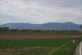
I'll have to climb two of these
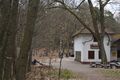
On top of the first the Totenkopfhütte (skull hut)
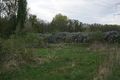
I left my bull...
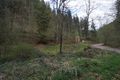
...in this valley...
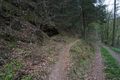
...and walked the left path up.
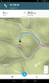
the walking part
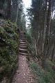
It was narrow, steep and hat some stairs.
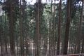
view from above (half way up)
a puddle near the hash

proof
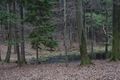
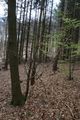
view from the hash
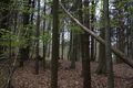
pretty much thesame in different directions
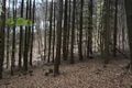
you can see the path on the left side

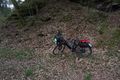
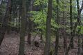
hasher
I found this X. There must be some Ninja-hasher (or description will follow)

Squishy and icecream
lilac bushes on my way back


Achievements
I think this should bring more because I'm really exhausted now, but it is just
DODO earned the Land geohash achievement
|