Difference between revisions of "2017-05-01 48 9"
imported>Drei aus Korb (→Photos) |
imported>FippeBot m (Location) |
||
| (2 intermediate revisions by 2 users not shown) | |||
| Line 35: | Line 35: | ||
| − | I took the car to get to a parking lot at the Jägerhaus, a famous place and restaurant nearby the woods; the two girls didn't want to join me, | + | I took the car to get to a parking lot at the Jägerhaus, a famous place and restaurant nearby the woods; the two girls didn't want to join me, they preferred to stay at home. Dressed like in fall I made my through the rain into the forest. On my way I first wanted to reach the geocache "Rosskopf" in about 1 km distance. When I found it I headed for the hash eastwards in a distance of about 800 m. |
| − | You won't believe it: when I got as close as 30 m two people were hanging around and another one with a dog went slooooooowly by. And I haven't met a person in the last hour at all. I studied my smartphone-map very thoroughly until | + | You won't believe it: when I got as close as 30 m two people were hanging around and another one with a dog went slooooooowly by. And I haven't met a person in the last hour at all. I studied my smartphone-map very thoroughly until they finally disappeared. |
| − | Then I dared to leave the official trail | + | Then I dared to leave the official trail and got into the underwoods. |
| − | Finally there: the hashpoint has | + | Finally there: the hashpoint has been "marked" by a big tree stump. |
After having taken a view pictures I finally made my way back to the parking lot 1,5 kms through the woods and in the rain. | After having taken a view pictures I finally made my way back to the parking lot 1,5 kms through the woods and in the rain. | ||
| Line 63: | Line 63: | ||
<!-- Add any achievement ribbons you earned below, or remove this section --> | <!-- Add any achievement ribbons you earned below, or remove this section --> | ||
| − | |||
| − | |||
| − | |||
| − | |||
| − | |||
| − | |||
| − | |||
| − | |||
| − | |||
| − | |||
| − | |||
| − | |||
| − | |||
| − | |||
[[Category:Expeditions]] | [[Category:Expeditions]] | ||
| − | |||
[[Category:Expeditions with photos]] | [[Category:Expeditions with photos]] | ||
| − | |||
| − | |||
| − | |||
| − | |||
| − | |||
[[Category:Coordinates reached]] | [[Category:Coordinates reached]] | ||
| − | + | {{location|DE|BW|ES}} | |
| − | |||
| − | |||
| − | |||
| − | |||
| − | |||
| − | |||
| − | |||
| − | |||
| − | |||
| − | |||
| − | |||
| − | |||
| − | |||
| − | |||
| − | |||
| − | |||
| − | |||
Latest revision as of 18:28, 26 July 2019
| Mon 1 May 2017 in 48,9: 48.7481226, 9.3669442 geohashing.info google osm bing/os kml crox |
Location
At the Stettener Bach in the Schurwald woods between Esslingen Jägerhaus and Aichwald
Participants
Holger / Drei aus Korb
Plans
The plan was to stay at home at this first of may because the weather was lausy and it was raining all the time. But a geohash so close and in the woods...who can resist?
Expedition
- Schurwald: the woods between Jägerhaus and Aichwald -- Drei aus Korb (talk) @48.7481,9.3669 14:01, 1 May 2017 (GMT+02:00)
I took the car to get to a parking lot at the Jägerhaus, a famous place and restaurant nearby the woods; the two girls didn't want to join me, they preferred to stay at home. Dressed like in fall I made my through the rain into the forest. On my way I first wanted to reach the geocache "Rosskopf" in about 1 km distance. When I found it I headed for the hash eastwards in a distance of about 800 m.
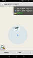
You won't believe it: when I got as close as 30 m two people were hanging around and another one with a dog went slooooooowly by. And I haven't met a person in the last hour at all. I studied my smartphone-map very thoroughly until they finally disappeared.
Then I dared to leave the official trail and got into the underwoods.
Finally there: the hashpoint has been "marked" by a big tree stump.
After having taken a view pictures I finally made my way back to the parking lot 1,5 kms through the woods and in the rain.
Tracklog
Photos
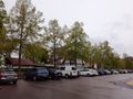
Parking lot at the Jägerhaus Esslingen
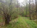
On my way to the hash
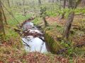
Stettener Bach
Logproof
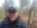
Stupid grin in the rain
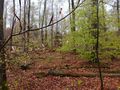
Looking around 1
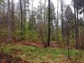
Looking around 2
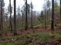
Looking around 3
Looking around 4


