Difference between revisions of "2017-05-07 50 18"
imported>Malgond (Created page with "{{subst:Expedition |lat = 50 |lon = 18 |date = 2017-05-07 }}") |
imported>FippeBot m (Location) |
||
| (19 intermediate revisions by one other user not shown) | |||
| Line 1: | Line 1: | ||
| − | |||
| − | |||
| − | |||
| − | |||
| − | |||
| − | |||
| − | |||
| − | |||
| − | |||
| − | |||
{{meetup graticule | {{meetup graticule | ||
| lat=50 | | lat=50 | ||
| Line 15: | Line 5: | ||
}} | }} | ||
| − | |||
__NOTOC__ | __NOTOC__ | ||
== Location == | == Location == | ||
| − | + | ||
| + | On an ovegrown abandoned post-industrial lot next to Obroki street in Katowice. | ||
== Participants == | == Participants == | ||
| − | + | [[User:Malgond|Malgond]] and his son. | |
| − | |||
== Plans == | == Plans == | ||
| − | < | + | |
| + | While checking the coordinates for the weekend I have noticed that one of the Sunday's points fall near the eastern border of the graticule located west of my home one, which I had not visited yet, close to the center of Katowice metropolitan area. It looked very promising at the first glance and I felt really excited when clicking the zoom button, eager to see if it falls in some accessible area or maybe within a closed industrial complex - and hurray! While it was not super-easy, it looked quite doable for a GPS-challenged geohasher like me. | ||
| + | |||
| + | It was located north-east of Witosa apartment complex in the western part of the city of Katowice, close to the A4 motorway leading to Kraków, so it was easy to get there even if it was further than all my previous geohashing destinations. On the map view it looked like a place near two buildings, one rectangular and one L-shaped, but when I have switched to satellite view I was surprised to see a patch of green; however when fully zoomed in it looked like there were concrete foundations present there, matching the map shapes, but partly overgrown with grass and bushes. The hash point was located betwen two prominent trees. The 3D view was also available and it provided a better survey. | ||
| + | |||
| + | <gallery perrow="5"> | ||
| + | Image:2017-05-07_50_18-p1.png | Hash point on Google Maps. | ||
| + | Image:2017-05-07_50_18-p2.png | Hash point on Google Maps, zoomed. | ||
| + | Image:2017-05-07_50_18-p3.png | Hash point in satellite view. | ||
| + | Image:2017-05-07_50_18-p4.png | Hash point in satellite view, zoomed. | ||
| + | Image:2017-05-07_50_18-p5.png | Hash point in 3D view. | ||
| + | </gallery> | ||
| + | |||
| + | For a still better orientation I have switched to street view. From the map it looked like the place would be accessible more easily from the west (Obroki street) next to a bus stop. However some old pipeline running along the street was seen from there and it was not clear if we would be able to cross it. On the other side of the street there was some industrial complex housing food wholesale businesses. Therefore I moved the view to the east side of the green patch next to another bus stop. It looked much better showing what looked like an access track. The roadside next to this other bus stop looked wide enough to park a car there even if it were a little boggy. There was no trace of the pipeline. So it is going to be the place to go. | ||
| + | |||
| + | <gallery perrow="5"> | ||
| + | Image:2017-05-07_50_18-p6.png | Access to the hash from the west. | ||
| + | Image:2017-05-07_50_18-p7.png | Industrial complex across the street. | ||
| + | Image:2017-05-07_50_18-p8.png | Meat wholesale ad. | ||
| + | Image:2017-05-07_50_18-p9.png | Access to the hash from the east. | ||
| + | </gallery> | ||
| + | |||
| + | To get the hashpoint I decided to use the concrete as a reference point and measured distance from the corner of the paved area along its edge and across the green. | ||
| + | |||
| + | [[Image:2017-05-07_50_18-p10.png]] [[Image:2017-05-07_50_18-p11.png]] | ||
== Expedition == | == Expedition == | ||
| − | |||
| − | + | The original plan was to set out well before noon to be back right for dinner - my wife was not impressed with an invitation to go this time. However it happened that she fell sick in the morning and therefore I had to take care of the dinner myself. I have tried to enlist kids with mixed success. My daughter helped with schnitzels but "got tired" afer just a few so I had to finish them off. The younger son eagerly helped to peel the potatos and cut them to prepare fries but cut his finger in the process. In the aftermath, we - the young hero and me - were able to start just before 6 p.m. But no worries - there's the motorway... | |
| − | + | ||
| + | After about fifty minutes we've arrived to the western outskirts of Katowice. In the hurried preparations I have made a small mistake - I've printed only the map of the hashpoint's surroundings but have not asked Google for directions. The street I was planning to drive down on the straight way to the hash appeared to be one-way and I had to find a detour. After some tries at parallel streets and some dead-ends I finally got out of Witosa residential district onto the homonymous street and turned left into Obroki street towards our destination. We've parked on the slightly muddy roadside as planned. Then I tried to take a photo of the bus stop resembling the Google's one as much as possible. | ||
| − | |||
| − | |||
| − | |||
| − | |||
<gallery perrow="5"> | <gallery perrow="5"> | ||
| + | Image:2017-05-07_50_18-1.JPG | LIDL shop on the intersection of Witosa and Obroki streets. | ||
| + | Image:2017-05-07_50_18-2.JPG | On the way to the hash. | ||
| + | Image:2017-05-07_50_18-3.JPG | Still not there... | ||
| + | Image:2017-05-07_50_18-4.JPG | Almost there! | ||
| + | Image:2017-05-07_50_18-5.JPG | A bus stop in the middle of nowhere. | ||
</gallery> | </gallery> | ||
| − | + | The track leading away from the bus stop looked like a dirt road on street view but in fact was a strip of poured concrete covered with soil and dead leaves. It led us to an open space between big trees partially paved with cracked and deteriorating concrete, overgrown with moss, grass and small bushes. Judging from the industrial surroundings, probably some barracks or storage buildings stood there once and were later demolished, leaving concrete floors to the elements. I have located the corner of the rectangular patch of concrete and with the help of my son measured distance along the edge of it and then perpendicularly to it to locate the hash. | |
| − | |||
| − | |||
| − | < | + | <gallery perrow="6"> |
| − | + | Image:2017-05-07_50_18-6.JPG | A path towards the hashpoint. | |
| − | + | Image:2017-05-07_50_18-7.JPG | Overgrown concrete foundations. | |
| + | Image:2017-05-07_50_18-8.JPG | Old foundation next to the hashpoint. | ||
| + | Image:2017-05-07_50_18-9.JPG | We'll start measuring from here. | ||
| + | Image:2017-05-07_50_18-10.JPG | Taking measurement along the concrete slab... | ||
| + | Image:2017-05-07_50_18-11.JPG | ...and across the lawn. | ||
| + | </gallery> | ||
| − | + | Another success! We were really happy to have our next successful expedition together. It was a quarter past seven. As both the sunlight and the camera's battery charge started to diminish we have made a few quick photos at the geohash. | |
| − | < | + | <gallery perrow="5"> |
| − | + | Image:2017-05-07_50_18-12.JPG | Happy young geohasher. | |
| − | + | Image:2017-05-07_50_18-13.JPG | The hash lies about there... | |
| − | --> | + | Image:2017-05-07_50_18-14.JPG | Me at the hash. |
| + | Image:2017-05-07_50_18-15.JPG | Dual stupid grin. | ||
| + | </gallery> | ||
| − | + | After documenting our victory we went for a small reconnaissance. Walking along a footpath leading to the east we've reached the mysterious pipeline and were able to get under it to the other side and arrived at the street I had surveyed before. We've made a few photos to match what I've seen in the Google street view. I have also photographed the bus timetable. | |
| − | < | + | <gallery perrow="5"> |
| + | Image:2017-05-07_50_18-16.JPG | | ||
| + | Image:2017-05-07_50_18-17.JPG | | ||
| + | Image:2017-05-07_50_18-19.JPG | | ||
| + | Image:2017-05-07_50_18-18.JPG | | ||
| + | </gallery> | ||
| + | |||
| + | After that we walked back to our car and drove home. We have covered 160 kilometers this day. | ||
| + | |||
| + | == Achievements == | ||
| + | {{#vardefine:ribbonwidth|800px}} | ||
| + | [[Category:Poland]] | ||
[[Category:Expeditions]] | [[Category:Expeditions]] | ||
| − | + | [[Category:Coordinates reached]] | |
[[Category:Expeditions with photos]] | [[Category:Expeditions with photos]] | ||
| − | |||
[[Category:Expedition without GPS]] | [[Category:Expedition without GPS]] | ||
| − | |||
| − | |||
| − | |||
| − | |||
| + | {{land geohash | ||
| + | | latitude = 50 | ||
| + | | longitude = 18 | ||
| + | | date = 2017-05-07 | ||
| + | | name = [[User:Malgond|Malgond]] | ||
| + | | image = 2017-05-07_50_18-13.JPG | ||
| + | }} | ||
| − | - | + | {{drag-along |
| − | + | | latitude = 50 | |
| − | -- | + | | longitude = 18 |
| − | + | | date = 2017-05-07 | |
| − | [[ | + | | name = [[User:Malgond|Malgond]] |
| − | + | | partner = his son | |
| − | + | | image = 2017-05-07_50_18-15.JPG | |
| − | + | }} | |
| − | + | {{No_batteries_geohash | |
| − | + | | latitude = 50 | |
| − | + | | longitude = 18 | |
| − | + | | date = 2017-05-07 | |
| − | [[ | + | | name = [[User:Malgond|Malgond]] |
| + | | image = 2017-05-07_50_18-11.JPG | ||
| + | }} | ||
| − | + | {{Minesweeper geohash | |
| + | | graticule = Kraków, Poland | ||
| + | | ranknumber = 4 | ||
| + | | e = true | ||
| + | | s = true | ||
| + | | se = true | ||
| + | | w = true | ||
| + | | name = [[User:Malgond|Malgond]] | ||
| + | }} | ||
| + | {{location|PL|S|K}} | ||
Latest revision as of 01:00, 6 August 2019
| Sun 7 May 2017 in 50,18: 50.2678502, 18.9601292 geohashing.info google osm bing/os kml crox |
Location
On an ovegrown abandoned post-industrial lot next to Obroki street in Katowice.
Participants
Malgond and his son.
Plans
While checking the coordinates for the weekend I have noticed that one of the Sunday's points fall near the eastern border of the graticule located west of my home one, which I had not visited yet, close to the center of Katowice metropolitan area. It looked very promising at the first glance and I felt really excited when clicking the zoom button, eager to see if it falls in some accessible area or maybe within a closed industrial complex - and hurray! While it was not super-easy, it looked quite doable for a GPS-challenged geohasher like me.
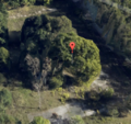
It was located north-east of Witosa apartment complex in the western part of the city of Katowice, close to the A4 motorway leading to Kraków, so it was easy to get there even if it was further than all my previous geohashing destinations. On the map view it looked like a place near two buildings, one rectangular and one L-shaped, but when I have switched to satellite view I was surprised to see a patch of green; however when fully zoomed in it looked like there were concrete foundations present there, matching the map shapes, but partly overgrown with grass and bushes. The hash point was located betwen two prominent trees. The 3D view was also available and it provided a better survey.
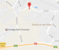
Hash point on Google Maps.
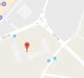
Hash point on Google Maps, zoomed.
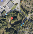
Hash point in satellite view.
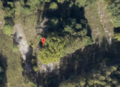
Hash point in satellite view, zoomed.
Hash point in 3D view.


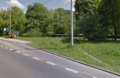
For a still better orientation I have switched to street view. From the map it looked like the place would be accessible more easily from the west (Obroki street) next to a bus stop. However some old pipeline running along the street was seen from there and it was not clear if we would be able to cross it. On the other side of the street there was some industrial complex housing food wholesale businesses. Therefore I moved the view to the east side of the green patch next to another bus stop. It looked much better showing what looked like an access track. The roadside next to this other bus stop looked wide enough to park a car there even if it were a little boggy. There was no trace of the pipeline. So it is going to be the place to go.
Access to the hash from the west.
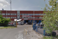
Industrial complex across the street.
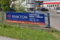
Meat wholesale ad.
Access to the hash from the east.


To get the hashpoint I decided to use the concrete as a reference point and measured distance from the corner of the paved area along its edge and across the green.


Expedition
The original plan was to set out well before noon to be back right for dinner - my wife was not impressed with an invitation to go this time. However it happened that she fell sick in the morning and therefore I had to take care of the dinner myself. I have tried to enlist kids with mixed success. My daughter helped with schnitzels but "got tired" afer just a few so I had to finish them off. The younger son eagerly helped to peel the potatos and cut them to prepare fries but cut his finger in the process. In the aftermath, we - the young hero and me - were able to start just before 6 p.m. But no worries - there's the motorway...
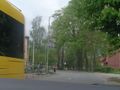
After about fifty minutes we've arrived to the western outskirts of Katowice. In the hurried preparations I have made a small mistake - I've printed only the map of the hashpoint's surroundings but have not asked Google for directions. The street I was planning to drive down on the straight way to the hash appeared to be one-way and I had to find a detour. After some tries at parallel streets and some dead-ends I finally got out of Witosa residential district onto the homonymous street and turned left into Obroki street towards our destination. We've parked on the slightly muddy roadside as planned. Then I tried to take a photo of the bus stop resembling the Google's one as much as possible.
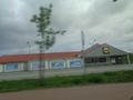
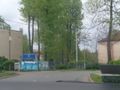
LIDL shop on the intersection of Witosa and Obroki streets.
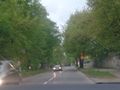
On the way to the hash.
Still not there...
Almost there!
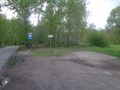
A bus stop in the middle of nowhere.


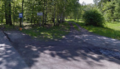
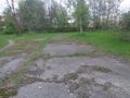
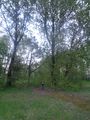
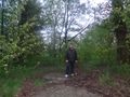
The track leading away from the bus stop looked like a dirt road on street view but in fact was a strip of poured concrete covered with soil and dead leaves. It led us to an open space between big trees partially paved with cracked and deteriorating concrete, overgrown with moss, grass and small bushes. Judging from the industrial surroundings, probably some barracks or storage buildings stood there once and were later demolished, leaving concrete floors to the elements. I have located the corner of the rectangular patch of concrete and with the help of my son measured distance along the edge of it and then perpendicularly to it to locate the hash.
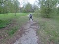
A path towards the hashpoint.
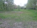
Overgrown concrete foundations.
Old foundation next to the hashpoint.
We'll start measuring from here.
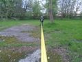
Taking measurement along the concrete slab...
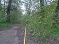
...and across the lawn.


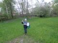
Another success! We were really happy to have our next successful expedition together. It was a quarter past seven. As both the sunlight and the camera's battery charge started to diminish we have made a few quick photos at the geohash.
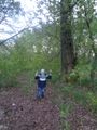
Happy young geohasher.
The hash lies about there...
Me at the hash.
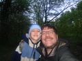
Dual stupid grin.


After documenting our victory we went for a small reconnaissance. Walking along a footpath leading to the east we've reached the mysterious pipeline and were able to get under it to the other side and arrived at the street I had surveyed before. We've made a few photos to match what I've seen in the Google street view. I have also photographed the bus timetable.


After that we walked back to our car and drove home. We have covered 160 kilometers this day.
Achievements
Malgond earned the Land geohash achievement
|
Malgond earned the Drag-along achievement
|
Malgond earned the No Batteries Geohash Achievement
|
Malgond achieved level 4 of the Minesweeper Geohash achievement
|