Difference between revisions of "2017-05-13 53 -2"
From Geohashing
imported>Angel ([live picture] [http://www.openstreetmap.org/?lat=53.57150470&lon=-2.61220070&zoom=16&layers=B000FTF @53.5715,-2.6122]) |
imported>FippeBot m (Location) |
||
| (3 intermediate revisions by 2 users not shown) | |||
| Line 1: | Line 1: | ||
| + | [[Image:{{{image|2017-05-13_53_-2_Angel_1494683631070.jpg}}}|thumb|left]] | ||
| − | |||
| − | |||
| − | |||
| − | |||
| − | |||
| − | |||
| − | |||
| − | |||
| − | |||
{{meetup graticule | {{meetup graticule | ||
| lat=53 | | lat=53 | ||
| Line 15: | Line 7: | ||
}} | }} | ||
| − | |||
__NOTOC__ | __NOTOC__ | ||
== Location == | == Location == | ||
| − | + | Somewhere around Haigh Hall and gardens. Not actually too sure where that is, but we used to walk round the gardens quite often as kids; so I'll go stay with mum for the weekend. | |
== Participants == | == Participants == | ||
| − | + | * [[User:Angel|Angel]] ([[User talk:Angel|talk]]) | |
| − | + | * Angel's mum | |
== Plans == | == Plans == | ||
| − | + | Get mum to give me a lift up to the hall, and walk around until I find out how close I can get to the hash. Hope it's not on the golf course, it's hard to tell. | |
== Expedition == | == Expedition == | ||
| − | + | *Somewhere around Haigh Hall; worth checking to see if it's reachable. -- [[User:Angel|Angel]] ([[User talk:Angel|talk]]) [http://www.openstreetmap.org/?lat=53.53657730&lon=-2.68529440&zoom=16&layers=B000FTF @53.5366,-2.6853] 14:19, 13 May 2017 (GMT+01:00) | |
| + | In the end, we found it without too much trouble. it was on the golf course, but could get there by mostly sticking to the paths, and without getting in the way of any golfers. Went the long way around on the way back to the car, grabbing some portals to improve my Ingress score for the week. | ||
| − | |||
== Tracklog == | == Tracklog == | ||
| − | + | [https://www.endomondo.com/users/3871875/workouts/922451604 Map on Endomondo] | |
== Photos == | == Photos == | ||
| − | |||
| − | |||
| − | |||
<gallery perrow="5"> | <gallery perrow="5"> | ||
| Line 45: | Line 33: | ||
Image:2017-05-13_53_-2_Angel_1494683631070.jpg| [http://www.openstreetmap.org/?lat=53.57150470&lon=-2.61220070&zoom=16&layers=B000FTF @53.5715,-2.6122] | Image:2017-05-13_53_-2_Angel_1494683631070.jpg| [http://www.openstreetmap.org/?lat=53.57150470&lon=-2.61220070&zoom=16&layers=B000FTF @53.5715,-2.6122] | ||
| + | |||
| + | Image:2017-05-13_53_-2_Angel_1494683796172.jpg|A panorama from the hash point, with my mum on it [http://www.openstreetmap.org/?lat=53.57157060&lon=-2.61263660&zoom=16&layers=B000FTF @53.5716,-2.6126] | ||
</gallery> | </gallery> | ||
== Achievements == | == Achievements == | ||
{{#vardefine:ribbonwidth|800px}} | {{#vardefine:ribbonwidth|800px}} | ||
| − | + | {{land geohash | |
| + | | latitude = 53 | ||
| + | | longitude = -2 | ||
| + | | date=2017-05-13 | ||
| + | | name = Angel | ||
| + | | image = 2017-05-13_53_-2_Angel_1494683631070.jpg | ||
| + | }} | ||
| − | + | {{drag-along | |
| − | + | | latitude = 53 | |
| − | + | | longitude = -2 | |
| − | + | | date=2017-05-13 | |
| − | + | | partner = his mum | |
| − | + | | name = Angel | |
| − | + | | image = 2017-05-13_53_-2_Angel_1494683796172.jpg | |
| − | + | }} | |
| − | |||
| − | |||
| − | |||
| − | |||
| − | |||
[[Category:Expeditions]] | [[Category:Expeditions]] | ||
| − | |||
[[Category:Expeditions with photos]] | [[Category:Expeditions with photos]] | ||
| − | |||
| − | |||
| − | |||
| − | |||
| − | |||
[[Category:Coordinates reached]] | [[Category:Coordinates reached]] | ||
| − | + | {{location|GB|ENG|WGN}} | |
| − | |||
| − | |||
| − | |||
| − | |||
| − | |||
| − | |||
| − | |||
| − | |||
| − | |||
| − | |||
| − | |||
| − | |||
| − | |||
| − | |||
| − | |||
| − | |||
| − | |||
Latest revision as of 18:29, 26 July 2019
| Sat 13 May 2017 in 53,-2: 53.5715669, -2.6126325 geohashing.info google osm bing/os kml crox |
Location
Somewhere around Haigh Hall and gardens. Not actually too sure where that is, but we used to walk round the gardens quite often as kids; so I'll go stay with mum for the weekend.
Participants
Plans
Get mum to give me a lift up to the hall, and walk around until I find out how close I can get to the hash. Hope it's not on the golf course, it's hard to tell.
Expedition
- Somewhere around Haigh Hall; worth checking to see if it's reachable. -- Angel (talk) @53.5366,-2.6853 14:19, 13 May 2017 (GMT+01:00)
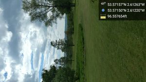
In the end, we found it without too much trouble. it was on the golf course, but could get there by mostly sticking to the paths, and without getting in the way of any golfers. Went the long way around on the way back to the car, grabbing some portals to improve my Ingress score for the week.
Tracklog
Photos
Somewhere across here @53.5716,-2.6109
A panorama from the hash point, with my mum on it @53.5716,-2.6126
Achievements
Angel earned the Land geohash achievement
|
Angel earned the Drag-along achievement
|


