Difference between revisions of "2017-07-11 61 23"
From Geohashing
imported>PJH FIN (Created page with "{{subst:Expedition |lat = 61 |lon = 23 |date = 2017-07-11 |image = image to show at the top of the page (optional) |TOC = t/f (optional. Set t to show TOC, f to not show it. D...") |
|||
| (4 intermediate revisions by 3 users not shown) | |||
| Line 1: | Line 1: | ||
| − | |||
| − | |||
| − | |||
| − | |||
| − | |||
| − | |||
| − | |||
| − | |||
| − | |||
| − | |||
{{meetup graticule | {{meetup graticule | ||
| lat=61 | | lat=61 | ||
| Line 22: | Line 12: | ||
== Participants == | == Participants == | ||
| − | [[User:PJH_FIN|PJH_FIN]] | + | [[User:PJH_FIN|PJH_FIN]] ([[User talk:PJH FIN|talk]]) |
== Plans == | == Plans == | ||
| Line 29: | Line 19: | ||
== Expedition == | == Expedition == | ||
The place was quite easy to reach from Pirkkala Ice Rink. Area was also a bit familiar because I have been geocaching here many years ago. It was a mystery cache by Team Pitkis. | The place was quite easy to reach from Pirkkala Ice Rink. Area was also a bit familiar because I have been geocaching here many years ago. It was a mystery cache by Team Pitkis. | ||
| − | |||
| − | |||
== Photos == | == Photos == | ||
| Line 36: | Line 24: | ||
Image:2012-##-## ## ## Alpha.jpg | Witty Comment | Image:2012-##-## ## ## Alpha.jpg | Witty Comment | ||
--> | --> | ||
| − | <gallery perrow=" | + | <gallery perrow="4"> |
| + | Image:2017_07_11_61_23_Magic Land.jpg|Magic Land - entering the hashpoint area | ||
| + | Image:2017_07_11_61_23_Hashpoint.jpg|At zero point | ||
| + | Image:2017_07_11_61_23_GPS.jpg|GPS coordinates | ||
| + | Image:2017_07_11_61_23_Smart Land.jpg|Smart Land - leaving the hashpoint area | ||
| + | Image:2017_07_11_61_23_Pirkkala Ice Rink.jpg|Pirkkala Ice Rink - 250 meters from zero point | ||
| + | Image:2017_07_11_61_23_Aircraft OH-ABC.jpg|Aircraft OH-ABC - 800 meters from zero point | ||
</gallery> | </gallery> | ||
| − | |||
| − | |||
| − | |||
| − | |||
| − | |||
| − | |||
| − | |||
| − | |||
| − | |||
| − | |||
| − | |||
| − | |||
| − | |||
| − | |||
| − | |||
| − | |||
[[Category:Expeditions]] | [[Category:Expeditions]] | ||
| − | |||
[[Category:Expeditions with photos]] | [[Category:Expeditions with photos]] | ||
| − | |||
| − | |||
| − | |||
| − | |||
| − | |||
[[Category:Coordinates reached]] | [[Category:Coordinates reached]] | ||
| − | + | {{location|FI|11}} | |
| − | |||
| − | |||
| − | |||
| − | |||
| − | |||
| − | |||
| − | |||
| − | |||
| − | |||
| − | |||
| − | |||
| − | |||
| − | |||
| − | |||
| − | |||
| − | |||
| − | |||
Latest revision as of 08:13, 19 May 2020
| Tue 11 Jul 2017 in 61,23: 61.4584015, 23.6470380 geohashing.info google osm bing/os kml crox |
Location
Small forest near Pirkkala center, 300 meters SW of lake Vähäjärvi. Between residential areas of Vähäjärvi and Takamaa.
Participants
Plans
I have followed geohashing hashpoints in Finland quite long time. Today I decided to create user account, visit my first hashpoint and log it here.
Expedition
The place was quite easy to reach from Pirkkala Ice Rink. Area was also a bit familiar because I have been geocaching here many years ago. It was a mystery cache by Team Pitkis.
Photos
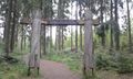
Magic Land - entering the hashpoint area
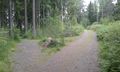
At zero point
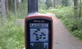
GPS coordinates
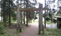
Smart Land - leaving the hashpoint area
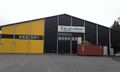
Pirkkala Ice Rink - 250 meters from zero point
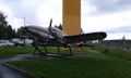
Aircraft OH-ABC - 800 meters from zero point


