Difference between revisions of "2017-08-12 63 28"
imported>Pastori (→Expedition) |
m |
||
| (2 intermediate revisions by 2 users not shown) | |||
| Line 46: | Line 46: | ||
{{land geohash | latitude = 63 | longitude = 28 | date = 2017-08-12 | name = Pastori | image = 2017-08-12 63 28DSC 0012 1500px.jpg | {{land geohash | latitude = 63 | longitude = 28 | date = 2017-08-12 | name = Pastori | image = 2017-08-12 63 28DSC 0012 1500px.jpg | ||
}} | }} | ||
| + | |||
| + | [[Category:Expeditions]] | ||
| + | [[Category:Expeditions with photos]] | ||
| + | [[Category:Coordinates reached]] | ||
| + | {{location|FI|13}} | ||
Latest revision as of 12:21, 23 September 2021
| Sat 12 Aug 2017 in 63,28: 63.4218019, 28.7809991 geohashing.info google osm bing/os kml crox |
Location
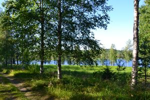
Nurmes, Palojärvi, Surmanlahti. The point lies next to a small road, in a birch forest.
Participants
- Pastori
- The Wife
Expedition
Today Pastori set course for southern Finland to meet his grandchildren and other relatives. As per his custom Pastori made sure he had plenty of extra days to travel and flexibility in his schedule. So he set off in high spirits accompanied by lovely warm weather and good company = Wife. Of course Pastori also kept his mind on possible hashpoints.
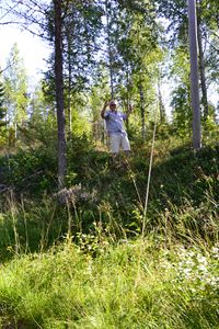
About 53km from home they stumbled on the first point while still in their home graticule. It only took a detour of about 500m off the main road on a smaller road and there the point was a short 10m to the side of the road and they reached the point with an accuracy of 2.508m.
The sun was shining brightly and they are happy to show off the sceneries from their home graticule and some views other than the usual thicket. Wife managed to take nice pictures just standing on the road in her smart shoes. The time was 09:55 am as they headed towards their next hashpoint and their lodgings in Central Finland.
Photos
Achievements
Pastori earned the Land geohash achievement
|


