Difference between revisions of "2017-09-02 51 13"
imported>Oisín (→Photos) |
imported>FippeBot m (Location) |
||
| (3 intermediate revisions by 2 users not shown) | |||
| Line 1: | Line 1: | ||
| − | + | {{meetup graticule | |
| − | |||
| − | |||
| − | |||
| − | |||
| − | |||
| − | |||
| − | |||
| − | |||
| − | |||
| − | {{meetup graticule | ||
| lat=51 | | lat=51 | ||
| lon=13 | | lon=13 | ||
| date=2017-09-02 | | date=2017-09-02 | ||
| − | }} | + | | graticule_name=Dresden |
| − | + | | graticule_link=Dresden, Germany | |
| − | + | }}__NOTOC__ | |
| − | + | == Location == | |
== Location == | == Location == | ||
| − | The hash is located at Obere Bergstraße in Radebeul. From the map it should be accessible. | + | The hash is located at Obere Bergstraße in Radebeul-Niederlößnitz. From the map it should be accessible. |
| + | |||
| + | Country: Germany; state: Sachsen (Saxony, EU:DE:SN); district: Meißen; municipality: Radebeul | ||
| + | |||
| + | Weather: mostly clouded | ||
== Participants == | == Participants == | ||
| − | [[User:Oisín|Oisín]] | + | *[[User:Oisín|Oisín]] |
| + | *[[User:Danatar|Danatar]] | ||
== Plans == | == Plans == | ||
| − | [[User:Oisín|Oisín]] plans to visit this hash in the afternoon. He'll be on his way to a [https://coord.info/GC76JQZ Geocaching Event]. | + | *[[User:Oisín|Oisín]] plans to visit this hash in the afternoon. He'll be on his way to a [https://coord.info/GC76JQZ Geocaching Event]. |
| + | *Danatar saw the coordinates and planned to be there at 4 p.m. He didn't check the wiki for other people's plans, else he would have tried to coordinate with Oisín. | ||
== Expedition == | == Expedition == | ||
| + | ===[[User:Oisín|Oisín]]=== | ||
I left home at around 3 p.m. First I cycled to one of our DIY markets as I had some small items on my shopping list. Then I continued my way diagonally through Radebeul to the Obere Bergstraße. Finally, at around 4:30pm the hash point was reached. The hash point lies between parking cars on a slope directly beside the road. After taking some pictures at the location I continued to the planeterium for an interesting presentation and nice talks around a camp fire. | I left home at around 3 p.m. First I cycled to one of our DIY markets as I had some small items on my shopping list. Then I continued my way diagonally through Radebeul to the Obere Bergstraße. Finally, at around 4:30pm the hash point was reached. The hash point lies between parking cars on a slope directly beside the road. After taking some pictures at the location I continued to the planeterium for an interesting presentation and nice talks around a camp fire. | ||
| − | |||
| − | |||
| − | |||
| − | |||
| − | |||
<gallery perrow="5"> | <gallery perrow="5"> | ||
Image:2017-09-02 51 13 Oisin 1.jpg | Oisín at the hash point | Image:2017-09-02 51 13 Oisin 1.jpg | Oisín at the hash point | ||
Image:2017-09-02 51 13 Oisin 2.jpg | Looking westwards | Image:2017-09-02 51 13 Oisin 2.jpg | Looking westwards | ||
Image:2017-09-02 51 13 Oisin 3.jpg | Stargazers at the planetarium | Image:2017-09-02 51 13 Oisin 3.jpg | Stargazers at the planetarium | ||
| + | Image:2017-09-02 51 13 Oisin Screenshot.png | Screenshot from GeoHash Droid app | ||
</gallery> | </gallery> | ||
| − | |||
{{#vardefine:ribbonwidth|800px}} | {{#vardefine:ribbonwidth|800px}} | ||
<!-- Add any achievement ribbons you earned below, or remove this section --> | <!-- Add any achievement ribbons you earned below, or remove this section --> | ||
{{Bicycle geohash | latitude = 51 | longitude = 13 | date = 2017-09-02 | name = Oisín | distance = 23 km | bothways = true}} | {{Bicycle geohash | latitude = 51 | longitude = 13 | date = 2017-09-02 | name = Oisín | distance = 23 km | bothways = true}} | ||
| + | |||
| + | ===[[User:Danatar|Danatar]]=== | ||
| + | |||
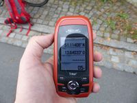
| + | I started my cycle tour to the hashpoint a bit later than planned, shortly after 3 p.m. After reaching the ''Elbradweg'' (Elbe cycle route) I followed that one to Mickten, then I went along the flood control channel, made a detour around the Autobahn and returned to the track that ran along the Elbe. At Radebeul-Kötzschenbroda the track ended and I cycled uphill until I reached ''Obere Bergstraße'' right before 4 p.m. The hashpoint was easy to find, it was on the side of the road and I didn't even have to step into the grass (in contrast to the satellite image). After taking pictures I started the return trip. Because of my excellent preparation I didn't know that Oisín was also planning to visit the hash. I'm not sure if I would have waited long enough to meet him though, because he didn't give a time. On the way back I took a different route but it did not lead me back to the Elbe until I was back at Mickten. | ||
| + | |||
| + | In total I cycled 31.5 km. | ||
| + | |||
| + | |||
| + | {{gallery|width=200|height=200|lines=2 | ||
| + | |Image:2017-09-02_51_13_gps.jpg|GPS | ||
| + | |Image:2017-09-02_51_13_hp.jpg|coordinates reached at 4 p.m. | ||
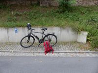
| + | |Image:2017-09-02_51_13_spot.jpg|the hashpoint | ||
| + | |Image:2017-09-02_51_13_panoW.jpg|panorama (part) | ||
| + | |Image:2017-09-02_51_13_panoE.jpg|panorama (part) | ||
| + | }} | ||
| + | |||
| + | [http://www.mygpsfiles.com/app/#https://www.dropbox.com/sh/l38ubdidvmv439v/AAD86wmSWBvthhUDC7qUzaAoa/2017/2017-09-02_51_13-triton.gpx triton tracklog] | ||
[[Category:Expeditions]] | [[Category:Expeditions]] | ||
[[Category:Expeditions with photos]] | [[Category:Expeditions with photos]] | ||
[[Category:Coordinates reached]] | [[Category:Coordinates reached]] | ||
| + | [[Category:Danatar]] | ||
| + | {{location|DE|SN|MEI}} | ||
Latest revision as of 02:56, 16 August 2019
| Sat 2 Sep 2017 in Dresden: 51.1140776, 13.6403481 geohashing.info google osm bing/os kml crox |
Location
Location
The hash is located at Obere Bergstraße in Radebeul-Niederlößnitz. From the map it should be accessible.
Country: Germany; state: Sachsen (Saxony, EU:DE:SN); district: Meißen; municipality: Radebeul
Weather: mostly clouded
Participants
Plans
- Oisín plans to visit this hash in the afternoon. He'll be on his way to a Geocaching Event.
- Danatar saw the coordinates and planned to be there at 4 p.m. He didn't check the wiki for other people's plans, else he would have tried to coordinate with Oisín.
Expedition
Oisín
I left home at around 3 p.m. First I cycled to one of our DIY markets as I had some small items on my shopping list. Then I continued my way diagonally through Radebeul to the Obere Bergstraße. Finally, at around 4:30pm the hash point was reached. The hash point lies between parking cars on a slope directly beside the road. After taking some pictures at the location I continued to the planeterium for an interesting presentation and nice talks around a camp fire.
Oisín earned the Bicycle geohash achievement
|
Danatar
I started my cycle tour to the hashpoint a bit later than planned, shortly after 3 p.m. After reaching the Elbradweg (Elbe cycle route) I followed that one to Mickten, then I went along the flood control channel, made a detour around the Autobahn and returned to the track that ran along the Elbe. At Radebeul-Kötzschenbroda the track ended and I cycled uphill until I reached Obere Bergstraße right before 4 p.m. The hashpoint was easy to find, it was on the side of the road and I didn't even have to step into the grass (in contrast to the satellite image). After taking pictures I started the return trip. Because of my excellent preparation I didn't know that Oisín was also planning to visit the hash. I'm not sure if I would have waited long enough to meet him though, because he didn't give a time. On the way back I took a different route but it did not lead me back to the Elbe until I was back at Mickten.
In total I cycled 31.5 km.
|


