Difference between revisions of "2017-11-15 31 35"
imported>Yosef (Created page with "{{subst:Expedition |lat = 31 |lon = 35 |date = 2017-11-15 }}") |
m |
||
| (10 intermediate revisions by 3 users not shown) | |||
| Line 20: | Line 20: | ||
== Location == | == Location == | ||
<!-- where you've surveyed the hash to be --> | <!-- where you've surveyed the hash to be --> | ||
| + | South of the settlement of Nili, Israel north of Deir Qaddis. | ||
== Participants == | == Participants == | ||
<!-- who attended: If you link to your wiki user name in this section, your expedition will be picked up by the various statistics generated for geohashing. You may use three tildes ~ as a shortcut to automatically insert the user signature of the account you are editing with. | <!-- who attended: If you link to your wiki user name in this section, your expedition will be picked up by the various statistics generated for geohashing. You may use three tildes ~ as a shortcut to automatically insert the user signature of the account you are editing with. | ||
--> | --> | ||
| + | [[User:Yosef|Yosef]] ([[User talk:Yosef|talk]]) | ||
== Plans == | == Plans == | ||
<!-- what were the original plans --> | <!-- what were the original plans --> | ||
| + | Take a bus to Shilat Junction. Hitchhike to Nili. Walk to the hashpoint through the town. | ||
== Expedition == | == Expedition == | ||
<!-- how it all turned out. your narrative goes here. --> | <!-- how it all turned out. your narrative goes here. --> | ||
| + | The bus trip to Shilat Junction was just fine and I actually got to an even better spot at the entrance of Modi'in 'Ilit (Kiryat Sefer for the locals). I picked up a hitch with a woman who preferred me getting off at a sane location and not at the southern edge of Nili like I would have liked and hitchhiking etiquette in Israel says that the driver is always right so I didn't complain. | ||
| + | |||
| + | I got off at a proper bus station near the north and only entrance of Nili. I decided that it would be a good idea to follow the fence of the Nili which would likely be safe and possibly easier. That was definitely wrong. I had to climb up a highway embankment and then every step was a decision where to walk next as the ground was very rocky. I stopped to pray the afternoon prayer when I got to the top and then continued to slowly walk. Soon afterward I heard the muezzin of Shebteen to the north for the Muslim sunset prayer. It was a friendly reminder that I wasn't Dorothy and I wasn't in Kansas. | ||
| + | |||
| + | After a frustrating amount of ambling, I decided that I would look at a Google Maps satellite image. There was actually a trail from the highway almost to the point. That would make my life a lot easier. By then it was dark and I decided to continue to the trail ambling over all of the rocks and brush. The trail ended up being relatively fast and it lead to a right turn back towards a trail that led to Nili. When I made it to a final road that led to Nili from the southeast (I started at the northern entrance), I realized that I was less than one-hundred meters from the hash point. | ||
| + | |||
| + | I had to climb a small wall of rocks to advance towards the hashpoint and then climbed over several other rocks. I started to notice a few trees that were not olives. They didn't seem to have fruit on them but they were likely out of season. I kept walking. The rocks were pretty sharp. I heard the muezzin for the Muslim night prayer this time from Deir Qaddis to the south. This might have been stupid. I slowed down to find the hashpoint and then sat down to take screenshots. I wouldn't be able to successfully take a selfie tonight. | ||
| + | |||
| + | I walked down the trail from the hash towards the highway and followed it to the northern edge of Nili where there was a bus station. From there I was able to get a hitch relatively quickly to Shilat Junction and then from there to Jerusalem. I was tired and soon went to sleep. | ||
== Tracklog == | == Tracklog == | ||
| Line 39: | Line 51: | ||
--> | --> | ||
<gallery perrow="5"> | <gallery perrow="5"> | ||
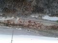
| + | Image:20171115 163530.jpg | Shebteen | ||
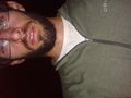
| + | Image:20171115 181200.jpg | That was dumb | ||
| + | Image:Screenshot 2017-11-15-17-55-55.png | Proof | ||
</gallery> | </gallery> | ||
| Line 44: | Line 59: | ||
{{#vardefine:ribbonwidth|800px}} | {{#vardefine:ribbonwidth|800px}} | ||
<!-- Add any achievement ribbons you earned below, or remove this section --> | <!-- Add any achievement ribbons you earned below, or remove this section --> | ||
| − | |||
| − | |||
| − | |||
| − | |||
| − | |||
| − | |||
<!-- Potential categories. Please include all the ones appropriate to your expedition --> | <!-- Potential categories. Please include all the ones appropriate to your expedition --> | ||
| Line 57: | Line 66: | ||
<!-- If all those plans are never acted upon, change [[Category:Expedition planning]] to [[Category:Not reached - Did not attempt]]. --> | <!-- If all those plans are never acted upon, change [[Category:Expedition planning]] to [[Category:Not reached - Did not attempt]]. --> | ||
| + | [[Category:Expeditions with photos]] | ||
| + | |||
| + | {{Combo | ||
| + | |||
| + | | latitude = 31 | ||
| + | | longitude = 35 | ||
| + | | date = 2017-11-15 | ||
| + | | comboname = 5th Ammendment | ||
| + | | action = pleading the [[wikipedia: Fifth Ammendment|fifth amendment]] when asked what was really there | ||
| + | | name = Yosef | ||
| + | | icon1 = five.jpg | ||
| + | }} | ||
| − | |||
[[Category:Expeditions]] | [[Category:Expeditions]] | ||
| − | |||
[[Category:Expeditions with photos]] | [[Category:Expeditions with photos]] | ||
| − | |||
| − | |||
| − | |||
| − | |||
| − | |||
[[Category:Coordinates reached]] | [[Category:Coordinates reached]] | ||
| − | + | {{location|IL|YS}} | |
| − | |||
| − | |||
| − | |||
| − | |||
| − | |||
| − | |||
| − | |||
| − | |||
| − | |||
| − | |||
| − | |||
| − | |||
| − | |||
| − | |||
| − | |||
| − | |||
| − | |||
Latest revision as of 12:29, 23 September 2021
| Wed 15 Nov 2017 in 31,35: 31.9571517, 35.0476029 geohashing.info google osm bing/os kml crox |
Location
South of the settlement of Nili, Israel north of Deir Qaddis.
Participants
Plans
Take a bus to Shilat Junction. Hitchhike to Nili. Walk to the hashpoint through the town.
Expedition
The bus trip to Shilat Junction was just fine and I actually got to an even better spot at the entrance of Modi'in 'Ilit (Kiryat Sefer for the locals). I picked up a hitch with a woman who preferred me getting off at a sane location and not at the southern edge of Nili like I would have liked and hitchhiking etiquette in Israel says that the driver is always right so I didn't complain.
I got off at a proper bus station near the north and only entrance of Nili. I decided that it would be a good idea to follow the fence of the Nili which would likely be safe and possibly easier. That was definitely wrong. I had to climb up a highway embankment and then every step was a decision where to walk next as the ground was very rocky. I stopped to pray the afternoon prayer when I got to the top and then continued to slowly walk. Soon afterward I heard the muezzin of Shebteen to the north for the Muslim sunset prayer. It was a friendly reminder that I wasn't Dorothy and I wasn't in Kansas.
After a frustrating amount of ambling, I decided that I would look at a Google Maps satellite image. There was actually a trail from the highway almost to the point. That would make my life a lot easier. By then it was dark and I decided to continue to the trail ambling over all of the rocks and brush. The trail ended up being relatively fast and it lead to a right turn back towards a trail that led to Nili. When I made it to a final road that led to Nili from the southeast (I started at the northern entrance), I realized that I was less than one-hundred meters from the hash point.
I had to climb a small wall of rocks to advance towards the hashpoint and then climbed over several other rocks. I started to notice a few trees that were not olives. They didn't seem to have fruit on them but they were likely out of season. I kept walking. The rocks were pretty sharp. I heard the muezzin for the Muslim night prayer this time from Deir Qaddis to the south. This might have been stupid. I slowed down to find the hashpoint and then sat down to take screenshots. I wouldn't be able to successfully take a selfie tonight.
I walked down the trail from the hash towards the highway and followed it to the northern edge of Nili where there was a bus station. From there I was able to get a hitch relatively quickly to Shilat Junction and then from there to Jerusalem. I was tired and soon went to sleep.
Tracklog
Photos
Shebteen
That was dumb
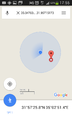
Proof


Achievements
Yosef earned the 5th Ammendment Achievement
|