Difference between revisions of "2017-11-18 51 9"
From Geohashing
imported>GeorgDerReisende (new report) |
imported>FippeBot m (Location) |
||
| (One intermediate revision by one other user not shown) | |||
| Line 1: | Line 1: | ||
| − | |||
| − | |||
| − | |||
| − | |||
| − | |||
| − | |||
| − | |||
| − | |||
| − | |||
| − | |||
{{meetup graticule | {{meetup graticule | ||
| lat=51 | | lat=51 | ||
| Line 19: | Line 9: | ||
== Location == | == Location == | ||
| − | + | The hash lay in the street ''Auf der Igelstätte'' in Oberelsungen. | |
== Participants == | == Participants == | ||
| − | + | ||
| − | + | [[User:GeorgDerReisende|GeorgDerReisende]] | |
== Plans == | == Plans == | ||
| − | + | ||
| + | Hitchhiking. | ||
== Expedition == | == Expedition == | ||
| − | |||
| − | + | I left home at 13:10, which was a little late for the best time, but at the Wilhelmshöhe junction I got a car with a short waiting time and it drove into the village of Oberelsungen. There I arrived at 14:30. I walked around the village and at last to the hash. It lay into an old fieldway between newer houses more or less on its side. I dance around, had several times a 0 m shot, but for the photo I got only one meter. | |
| − | |||
== Photos == | == Photos == | ||
| − | |||
| − | |||
| − | |||
<gallery perrow="5"> | <gallery perrow="5"> | ||
| + | Image:2017-11-18 51 9 GeorgDerReisende 5613.jpg | in the street or on its left side, 15 m away | ||
| + | Image:2017-11-18 51 9 GeorgDerReisende 5615.jpg | proof | ||
| + | Image:2017-11-18 51 9 GeorgDerReisende 5617.jpg | the north | ||
| + | Image:2017-11-18 51 9 GeorgDerReisende 5618.jpg | the west | ||
| + | Image:2017-11-18 51 9 GeorgDerReisende 5619.jpg | the east | ||
| + | Image:2017-11-18 51 9 GeorgDerReisende 5616.jpg | the south | ||
| + | Image:2017-11-18 51 9 GeorgDerReisende 5620.jpg | the geohasher | ||
</gallery> | </gallery> | ||
| Line 45: | Line 38: | ||
<!-- Add any achievement ribbons you earned below, or remove this section --> | <!-- Add any achievement ribbons you earned below, or remove this section --> | ||
| − | + | {{Thumbs Up | latitude = 51 | longitude = 9 | date = 2017-11-18 | name = GeorgDerReisende }} | |
| − | |||
| − | |||
| − | + | [[Category:Expeditions]] | |
| − | + | [[Category:Expeditions with photos]] | |
| − | |||
| − | [[Category: | ||
| − | |||
| − | |||
| − | |||
| − | |||
| − | |||
| − | |||
| − | |||
| − | |||
| − | |||
| − | |||
| − | |||
| − | |||
[[Category:Coordinates reached]] | [[Category:Coordinates reached]] | ||
| − | + | {{location|DE|HE|KS}} | |
| − | |||
| − | |||
| − | |||
| − | |||
| − | |||
| − | |||
| − | |||
| − | |||
| − | |||
| − | |||
| − | |||
| − | |||
| − | |||
| − | |||
| − | |||
| − | |||
| − | |||
Latest revision as of 03:09, 16 August 2019
| Sat 18 Nov 2017 in 51,9: 51.3730867, 9.2389630 geohashing.info google osm bing/os kml crox |
Location
The hash lay in the street Auf der Igelstätte in Oberelsungen.
Participants
Plans
Hitchhiking.
Expedition
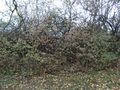
I left home at 13:10, which was a little late for the best time, but at the Wilhelmshöhe junction I got a car with a short waiting time and it drove into the village of Oberelsungen. There I arrived at 14:30. I walked around the village and at last to the hash. It lay into an old fieldway between newer houses more or less on its side. I dance around, had several times a 0 m shot, but for the photo I got only one meter.
Photos
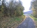
in the street or on its left side, 15 m away

proof
the north
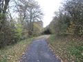
the west
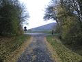
the east
the south
the geohasher


Achievements
GeorgDerReisende earned the Thumbs Up Geohash Achievement
|