Difference between revisions of "2017-11-29 53 -2"
From Geohashing
imported>KarMann (An expedition message sent via Geohash Droid for Android.) |
imported>FippeBot m (Location) |
||
| (4 intermediate revisions by 2 users not shown) | |||
| Line 31: | Line 31: | ||
<!-- how it all turned out. your narrative goes here. --> | <!-- how it all turned out. your narrative goes here. --> | ||
| + | |||
| + | *Hashpoint accomplished, if slightly late again. -- [[User:KarMann|KarMann]] ([[User talk:KarMann|talk]]) [http://www.openstreetmap.org/?lat=53.47707540&lon=-2.09225270&zoom=16&layers=B000FTF @53.4771,-2.0923] 16:32, 29 November 2017 (GMT+00:00) | ||
== Tracklog == | == Tracklog == | ||
<!-- if your GPS device keeps a log, you may post a link here --> | <!-- if your GPS device keeps a log, you may post a link here --> | ||
| Line 39: | Line 41: | ||
--> | --> | ||
<gallery perrow="5"> | <gallery perrow="5"> | ||
| + | |||
| + | Image:2017-11-29_53_-2_KarMann_1511973061386.jpg|The Yoga Centre [http://www.openstreetmap.org/?lat=53.47711500&lon=-2.09224850&zoom=16&layers=B000FTF @53.4771,-2.0922] | ||
| + | |||
| + | Image:2017-11-29_53_-2_KarMann_1511973100123.jpg|Myself in front of the hashpoint [http://www.openstreetmap.org/?lat=53.47710320&lon=-2.09223090&zoom=16&layers=B000FTF @53.4771,-2.0922] | ||
</gallery> | </gallery> | ||
| Line 45: | Line 51: | ||
<!-- Add any achievement ribbons you earned below, or remove this section --> | <!-- Add any achievement ribbons you earned below, or remove this section --> | ||
| − | |||
| − | |||
| − | |||
| − | |||
| − | |||
| − | |||
| − | |||
| − | |||
| − | |||
| − | |||
| − | |||
| − | |||
| − | |||
| − | |||
[[Category:Expeditions]] | [[Category:Expeditions]] | ||
| − | |||
[[Category:Expeditions with photos]] | [[Category:Expeditions with photos]] | ||
| − | |||
| − | |||
| − | |||
| − | |||
| − | |||
[[Category:Coordinates reached]] | [[Category:Coordinates reached]] | ||
| − | + | {{location|GB|ENG|TAM}} | |
| − | |||
| − | |||
| − | |||
| − | |||
| − | |||
| − | |||
| − | |||
| − | |||
| − | |||
| − | |||
| − | |||
| − | |||
| − | |||
| − | |||
| − | |||
| − | |||
| − | |||
Latest revision as of 18:35, 26 July 2019
| Wed 29 Nov 2017 in 53,-2: 53.4770812, -2.0922429 geohashing.info google osm bing/os kml crox |
Location
Participants
Plans
Expedition
- Hashpoint accomplished, if slightly late again. -- KarMann (talk) @53.4771,-2.0923 16:32, 29 November 2017 (GMT+00:00)
Tracklog
Photos
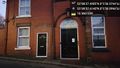
The Yoga Centre @53.4771,-2.0922
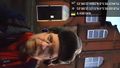
Myself in front of the hashpoint @53.4771,-2.0922

