Difference between revisions of "2018-01-04 31 34"
imported>Yosef (Created page with "{{subst:Expedition |lat = 31 |lon = 34 |date = 2018-01-04 }}") |
m |
||
| (4 intermediate revisions by 2 users not shown) | |||
| Line 20: | Line 20: | ||
== Location == | == Location == | ||
<!-- where you've surveyed the hash to be --> | <!-- where you've surveyed the hash to be --> | ||
| + | A field northeast of Erez, Israel in the 'Aza perimeter. | ||
| + | |||
== Participants == | == Participants == | ||
<!-- who attended: If you link to your wiki user name in this section, your expedition will be picked up by the various statistics generated for geohashing. You may use three tildes ~ as a shortcut to automatically insert the user signature of the account you are editing with. | <!-- who attended: If you link to your wiki user name in this section, your expedition will be picked up by the various statistics generated for geohashing. You may use three tildes ~ as a shortcut to automatically insert the user signature of the account you are editing with. | ||
--> | --> | ||
| + | [[User:Yosef|Yosef]] ([[User talk:Yosef|talk]]) | ||
== Plans == | == Plans == | ||
<!-- what were the original plans --> | <!-- what were the original plans --> | ||
| + | I'm usually driving around this area, so maybe it will be interesting. I hope to park inside Kibbutz Erez and then walk out to the point. | ||
| + | |||
| + | == A note on the location == | ||
| + | Kibbutz Erez is just north of the Gaza Strip. A kibbutz is a commune that is meant to be a mini communist village. They tend to have central dining halls and share many resources together, including usually a farm or a factory. Today, they are considered a failed experiment as many of them are privatizing. The Gaza Strip is an area that is supposed to be under the Palestinian Authority but is de facto run by Hamas. In 2014, Hamas succeeded in penetrating villages surrounding the Gaza Strip by digging underground tunnels so security tends to be tight in these areas. | ||
== Expedition == | == Expedition == | ||
<!-- how it all turned out. your narrative goes here. --> | <!-- how it all turned out. your narrative goes here. --> | ||
| + | I ended up finishing work in Ashdod in the early afternoon and drove down to Erez. I ended up missing a turn but quickly turned around. When I got to the gate of the town I saw that it was locked so I had to ask around at security to get them to open it for me so I could park inside. I parked, walked out of the town, wandered through the farm and then under both highway 34 and the train tracks until I arrived at the hashpoint. It was about a three kilometer walk. On the walk back I heard the sunset Muezzin from Gaza a few kilometers away. | ||
== Tracklog == | == Tracklog == | ||
| Line 39: | Line 47: | ||
--> | --> | ||
<gallery perrow="5"> | <gallery perrow="5"> | ||
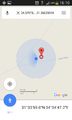
| + | Image:Screenshot 2018-01-04-16-10-42.png | proof | ||
| + | Image:20180104 161133.jpg | Me at the hashpoint | ||
</gallery> | </gallery> | ||
| Line 47: | Line 57: | ||
<!-- =============== USEFUL CATEGORIES FOLLOW ================ | <!-- =============== USEFUL CATEGORIES FOLLOW ================ | ||
Delete the next line ONLY if you have chosen the appropriate categories below. If you are unsure, don't worry. People will read your report and help you with the classification. --> | Delete the next line ONLY if you have chosen the appropriate categories below. If you are unsure, don't worry. People will read your report and help you with the classification. --> | ||
| − | + | ||
<!-- ==REQUEST FOR TWITTER BOT== Please leave either the New report or the Expedition planning category in as long as you work on it. This helps the twitter bot a lot with announcing the right outcome at the right moment. --> | <!-- ==REQUEST FOR TWITTER BOT== Please leave either the New report or the Expedition planning category in as long as you work on it. This helps the twitter bot a lot with announcing the right outcome at the right moment. --> | ||
| Line 58: | Line 68: | ||
<!-- If all those plans are never acted upon, change [[Category:Expedition planning]] to [[Category:Not reached - Did not attempt]]. --> | <!-- If all those plans are never acted upon, change [[Category:Expedition planning]] to [[Category:Not reached - Did not attempt]]. --> | ||
| − | |||
[[Category:Expeditions]] | [[Category:Expeditions]] | ||
| − | |||
[[Category:Expeditions with photos]] | [[Category:Expeditions with photos]] | ||
| − | |||
| − | |||
| − | |||
| − | |||
| − | |||
[[Category:Coordinates reached]] | [[Category:Coordinates reached]] | ||
| − | + | {{location|IL|D|AS}} | |
| − | |||
| − | |||
| − | |||
| − | |||
| − | |||
| − | |||
| − | |||
| − | |||
| − | |||
| − | |||
| − | |||
| − | |||
| − | |||
| − | |||
| − | |||
| − | |||
| − | |||
Latest revision as of 12:54, 23 September 2021
| Thu 4 Jan 2018 in 31,34: 31.5663952, 34.5797859 geohashing.info google osm bing/os kml crox |
Location
A field northeast of Erez, Israel in the 'Aza perimeter.
Participants
Plans
I'm usually driving around this area, so maybe it will be interesting. I hope to park inside Kibbutz Erez and then walk out to the point.
A note on the location
Kibbutz Erez is just north of the Gaza Strip. A kibbutz is a commune that is meant to be a mini communist village. They tend to have central dining halls and share many resources together, including usually a farm or a factory. Today, they are considered a failed experiment as many of them are privatizing. The Gaza Strip is an area that is supposed to be under the Palestinian Authority but is de facto run by Hamas. In 2014, Hamas succeeded in penetrating villages surrounding the Gaza Strip by digging underground tunnels so security tends to be tight in these areas.
Expedition
I ended up finishing work in Ashdod in the early afternoon and drove down to Erez. I ended up missing a turn but quickly turned around. When I got to the gate of the town I saw that it was locked so I had to ask around at security to get them to open it for me so I could park inside. I parked, walked out of the town, wandered through the farm and then under both highway 34 and the train tracks until I arrived at the hashpoint. It was about a three kilometer walk. On the walk back I heard the sunset Muezzin from Gaza a few kilometers away.
Tracklog
Photos
proof
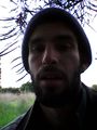
Me at the hashpoint

