Difference between revisions of "2018-01-01 60 24"
From Geohashing
imported>Hemlikkeli (→Achievements) |
imported>FippeBot m (Location) |
||
| (2 intermediate revisions by 2 users not shown) | |||
| Line 15: | Line 15: | ||
}} | }} | ||
| − | + | ||
__NOTOC__ | __NOTOC__ | ||
== Location == | == Location == | ||
| − | + | ||
The hash was in a forest in between a path and some industrial area. Located in Pitäjänmäki, Helsinki, near the Espoo border. | The hash was in a forest in between a path and some industrial area. Located in Pitäjänmäki, Helsinki, near the Espoo border. | ||
== Participants == | == Participants == | ||
| − | + | ||
| − | + | * [[User:Hemlikkeli|Hemlikkeli]] | |
| − | [[User:Hemlikkeli|Hemlikkeli]] | ||
== Expedition == | == Expedition == | ||
| − | + | ||
We started off near the Mäkkylä railway station (on the Espoo side). After that, we walked some 900 meters across a local park area. The hash was situated a few meters off the path, and it took us a while to find the right spot (due to an erratic GPS-tracker). There was some snow but it wasn't very cold. A great way to celebrate the New Year! | We started off near the Mäkkylä railway station (on the Espoo side). After that, we walked some 900 meters across a local park area. The hash was situated a few meters off the path, and it took us a while to find the right spot (due to an erratic GPS-tracker). There was some snow but it wasn't very cold. A great way to celebrate the New Year! | ||
| Line 35: | Line 34: | ||
Image:2012-##-## ## ## Alpha.jpg | Witty Comment | Image:2012-##-## ## ## Alpha.jpg | Witty Comment | ||
--> | --> | ||
| − | <gallery perrow=" | + | |
| + | <gallery perrow="4"> | ||
| + | 1.1.2018_60_24.jpg|A nice little pond on the way | ||
| + | 1.1.2018_60_242.jpg|We used the chimneys to estimate where the hash is | ||
| + | 1.1.2018_60_243.jpg|And for a moment the GPS agreed | ||
| + | 1.1.2018_60_244.jpg|So here we are | ||
| + | 1.1.2018_60_245.jpg|Goodbye | ||
| + | 1.1.2018_60_246.jpg|And back to the path | ||
</gallery> | </gallery> | ||
== Achievements == | == Achievements == | ||
{{#vardefine:ribbonwidth|800px}} | {{#vardefine:ribbonwidth|800px}} | ||
| − | |||
| − | |||
| − | |||
| − | |||
| − | |||
| − | + | * Land geohash | |
| − | |||
| − | |||
| − | |||
| − | |||
| − | |||
| − | |||
| − | |||
| − | |||
[[Category:Expeditions]] | [[Category:Expeditions]] | ||
| − | |||
[[Category:Expeditions with photos]] | [[Category:Expeditions with photos]] | ||
| − | |||
| − | |||
| − | |||
| − | |||
| − | |||
[[Category:Coordinates reached]] | [[Category:Coordinates reached]] | ||
| − | |||
| − | |||
| − | |||
| − | |||
| − | |||
| − | |||
| − | |||
| − | |||
| − | |||
| − | |||
| − | |||
| − | |||
| − | |||
| − | |||
| − | |||
| − | |||
| − | |||
| − | |||
<!-- {{land geohash | <!-- {{land geohash | ||
| Line 92: | Line 61: | ||
}} --> | }} --> | ||
| + | {{location|FI|18}} | ||
Latest revision as of 03:17, 16 August 2019
| Mon 1 Jan 2018 in 60,24: 60.2210058, 24.8533616 geohashing.info google osm bing/os kml crox |
Location
The hash was in a forest in between a path and some industrial area. Located in Pitäjänmäki, Helsinki, near the Espoo border.
Participants
Expedition
We started off near the Mäkkylä railway station (on the Espoo side). After that, we walked some 900 meters across a local park area. The hash was situated a few meters off the path, and it took us a while to find the right spot (due to an erratic GPS-tracker). There was some snow but it wasn't very cold. A great way to celebrate the New Year!
Photos
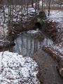
A nice little pond on the way
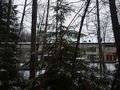
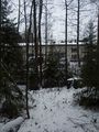
We used the chimneys to estimate where the hash is
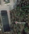
And for a moment the GPS agreed
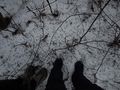
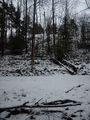
So here we are
Goodbye
And back to the path


Achievements
- Land geohash