Difference between revisions of "2018-02-25 51 4"
imported>FelixTheCat (Created page with "{{subst:Expedition |lat = 51 |lon = 4 |date = 2018-02-25 }}") |
imported>FippeBot m (Location) |
||
| (3 intermediate revisions by one other user not shown) | |||
| Line 1: | Line 1: | ||
| − | + | {{meetup graticule | |
| − | + | | map=<map lat="51" lon="4" date="2018-02-25" /> | |
| − | |||
| − | |||
| − | |||
| − | |||
| − | |||
| − | |||
| − | |||
| − | --> | ||
| − | |||
| lat=51 | | lat=51 | ||
| lon=4 | | lon=4 | ||
| date=2018-02-25 | | date=2018-02-25 | ||
}} | }} | ||
| − | |||
| − | |||
__NOTOC__ | __NOTOC__ | ||
| − | |||
== Location == | == Location == | ||
| − | + | To the south of Barendrecht, South Holland province, the Netherlands. | |
== Participants == | == Participants == | ||
| − | + | [[User:FelixTheCat|FelixTheCat]] ([[User talk:FelixTheCat|talk]]) | |
| − | + | ||
| + | == Expedition == | ||
| + | Today's hash was in a forest-like area on the southern edge of Barendrecht. This is a city in its own right, but nowadays it's really just a suburb of Rotterdam. Most of its residents are commuters who tried to escape the crowded and expensive inner areas of the city. | ||
| − | + | I had decided to go by train, so I took the Sunday morning "Sprinter" service towards Dordrecht. When I got off at Barendrecht station I noticed how incredibly quiet it was. It must be quite crowded on, say, a Monday morning, but early on Sunday the station was deserted. I then went to the bicycle storage facility to get myself a bike from the ''OV-fiets'' system, which is the bike sharing/rental service operated by the Dutch Railways. Barendrecht being a small station it had an interesting automated bike dispensing system which I hadn't used before. On large stations there is an attendant who hands you a bike, but here there is a computer which gives you a key which you can then use to unlock one of the bikes. | |
| − | |||
| − | + | Having picked up a bike and adjusted the seat I set off towards the hash. I made a quick stop along the way to admire a strange work of art consisting of a convex mirror atop a conical hill. I then continued on towards the forest, which apparently is a special kind of man-made landscape called a ''griend''. Basically, these are old willow plantations which have been given back to nature after the demand for willow dropped in the 1960s. I found the hash, took some pictures and went on my way again. | |
| − | |||
| − | + | I claimed the Public Transport Achievement, since I used the train for the bulk of the distance. Also, the bike system is called ''OV-fiets'' which literally means ''public transport bike'' so I guess it sort of counts as public transport too :-) | |
| − | |||
== Photos == | == Photos == | ||
| − | |||
| − | |||
| − | |||
<gallery perrow="5"> | <gallery perrow="5"> | ||
| + | Image:2018-02-25 51 4 FelixTheCat 1.JPG | The train rolling into Delft station. | ||
| + | Image:2018-02-25 51 4 FelixTheCat 2.JPG | The outside of Barendrecht station. | ||
| + | Image:2018-02-25 51 4 FelixTheCat 3.JPG | The bike key dispenser. You scan your card at the machine, after which the key box opens with a light indicating which key you should take. | ||
| + | Image:2018-02-25 51 4 FelixTheCat 4.JPG | This beauty was mine for today. | ||
| + | Image:2018-02-25 51 4 FelixTheCat 5.JPG | It was a nice, cold but sunny morning. | ||
| + | Image:2018-02-25 51 4 FelixTheCat 6.JPG | This strange mound stands out in an otherwise flat landscape. | ||
| + | Image:2018-02-25 51 4 FelixTheCat 7.JPG | At the summit there's this mirror. The mirror image sort of blends into the background, creating an interesting effect. | ||
| + | Image:2018-02-25 51 4 FelixTheCat 8.JPG | From the summit you also get a nice view of the city of Barendrecht. | ||
| + | Image:2018-02-25 51 4 FelixTheCat 9.JPG | Parked my bike at the entrance to the forest. | ||
| + | Image:2018-02-25 51 4 FelixTheCat 10.JPG | The hash was right next to this bench. | ||
| + | Image:2018-02-25 51 4 FelixTheCat 11.png | GPS proof. | ||
| + | Image:2018-02-25 51 4 FelixTheCat 12.JPG | Lloyd celebrating another success. | ||
| + | Image:2018-02-25 51 4 FelixTheCat 13.JPG | The willow trees that make this area a ''griend''. | ||
| + | Image:2018-02-25 51 4 FelixTheCat 14.JPG | There's actually plants growing in these trees. | ||
| + | Image:2018-02-25 51 4 FelixTheCat 15.JPG | A bit further on we can see the Oude Maas (Old Meuse) river which is used by many ships. | ||
</gallery> | </gallery> | ||
== Achievements == | == Achievements == | ||
{{#vardefine:ribbonwidth|800px}} | {{#vardefine:ribbonwidth|800px}} | ||
| − | + | {{Public transport geohash | |
| − | + | | latitude = 51 | |
| − | + | | longitude = 4 | |
| − | + | | date = 2018-02-25 | |
| − | + | | busline = Sprinter train and an OV-fiets | |
| − | + | | name = [[User:FelixTheCat|FelixTheCat]] ([[User talk:FelixTheCat|talk]]) | |
| − | + | }} | |
| − | |||
| − | |||
| − | |||
| − | |||
| − | |||
| − | |||
| − | |||
| − | |||
| − | |||
[[Category:Expeditions]] | [[Category:Expeditions]] | ||
| − | |||
[[Category:Expeditions with photos]] | [[Category:Expeditions with photos]] | ||
| − | |||
| − | |||
| − | |||
| − | |||
| − | |||
[[Category:Coordinates reached]] | [[Category:Coordinates reached]] | ||
| − | + | {{location|NL|ZH}} | |
| − | |||
| − | |||
| − | |||
| − | |||
| − | |||
| − | |||
| − | |||
| − | |||
| − | |||
| − | |||
| − | |||
| − | |||
| − | |||
| − | |||
| − | |||
| − | |||
| − | |||
Latest revision as of 03:22, 16 August 2019
| Sun 25 Feb 2018 in 51,4: 51.8391693, 4.4881392 geohashing.info google osm bing/os kml crox |
Location
To the south of Barendrecht, South Holland province, the Netherlands.
Participants
Expedition
Today's hash was in a forest-like area on the southern edge of Barendrecht. This is a city in its own right, but nowadays it's really just a suburb of Rotterdam. Most of its residents are commuters who tried to escape the crowded and expensive inner areas of the city.
I had decided to go by train, so I took the Sunday morning "Sprinter" service towards Dordrecht. When I got off at Barendrecht station I noticed how incredibly quiet it was. It must be quite crowded on, say, a Monday morning, but early on Sunday the station was deserted. I then went to the bicycle storage facility to get myself a bike from the OV-fiets system, which is the bike sharing/rental service operated by the Dutch Railways. Barendrecht being a small station it had an interesting automated bike dispensing system which I hadn't used before. On large stations there is an attendant who hands you a bike, but here there is a computer which gives you a key which you can then use to unlock one of the bikes.
Having picked up a bike and adjusted the seat I set off towards the hash. I made a quick stop along the way to admire a strange work of art consisting of a convex mirror atop a conical hill. I then continued on towards the forest, which apparently is a special kind of man-made landscape called a griend. Basically, these are old willow plantations which have been given back to nature after the demand for willow dropped in the 1960s. I found the hash, took some pictures and went on my way again.
I claimed the Public Transport Achievement, since I used the train for the bulk of the distance. Also, the bike system is called OV-fiets which literally means public transport bike so I guess it sort of counts as public transport too :-)
Photos
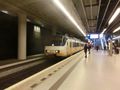
The train rolling into Delft station.
The outside of Barendrecht station.
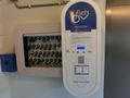
The bike key dispenser. You scan your card at the machine, after which the key box opens with a light indicating which key you should take.
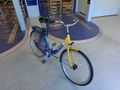
This beauty was mine for today.
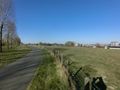
It was a nice, cold but sunny morning.
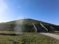
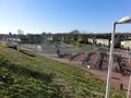
This strange mound stands out in an otherwise flat landscape.
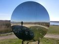
At the summit there's this mirror. The mirror image sort of blends into the background, creating an interesting effect.
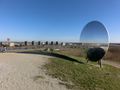
From the summit you also get a nice view of the city of Barendrecht.
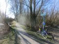
Parked my bike at the entrance to the forest.
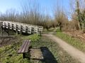
The hash was right next to this bench.
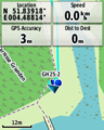
GPS proof.
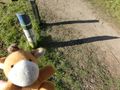
Lloyd celebrating another success.
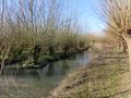
The willow trees that make this area a griend.
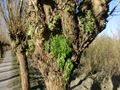
There's actually plants growing in these trees.
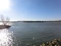
A bit further on we can see the Oude Maas (Old Meuse) river which is used by many ships.


Achievements
FelixTheCat (talk) earned the Public transport geohash achievement
|