Difference between revisions of "2018-03-31 49 8"
From Geohashing
imported>DODO (→Location) |
imported>FippeBot m (Location) |
||
| (9 intermediate revisions by 2 users not shown) | |||
| Line 25: | Line 25: | ||
<!-- who attended: If you link to your wiki user name in this section, your expedition will be picked up by the various statistics generated for geohashing. You may use three tildes ~ as a shortcut to automatically insert the user signature of the account you are editing with. | <!-- who attended: If you link to your wiki user name in this section, your expedition will be picked up by the various statistics generated for geohashing. You may use three tildes ~ as a shortcut to automatically insert the user signature of the account you are editing with. | ||
--> | --> | ||
| + | [[User:DODO|DODO]] | ||
== Plans == | == Plans == | ||
<!-- what were the original plans --> | <!-- what were the original plans --> | ||
| + | Go there by bull in the afternoon. I have to do the shopping first, so I'm not sure, when I can start. Try to be there at hash o'clock. | ||
| + | Will start soon (around 2 pm) and hope to arrive in an hour. | ||
== Expedition == | == Expedition == | ||
<!-- how it all turned out. your narrative goes here. --> | <!-- how it all turned out. your narrative goes here. --> | ||
| + | Just a 2 hours ride and a 50 m walk in the warm sunny springtime. | ||
== Tracklog == | == Tracklog == | ||
<!-- if your GPS device keeps a log, you may post a link here --> | <!-- if your GPS device keeps a log, you may post a link here --> | ||
| + | [https://www.komoot.de/tour/28514329 47 KM bullriding] | ||
== Photos == | == Photos == | ||
| Line 40: | Line 45: | ||
--> | --> | ||
<gallery perrow="5"> | <gallery perrow="5"> | ||
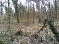
| + | Image:2018-03-31_49_8-1.jpg|bull, 25 m apart | ||
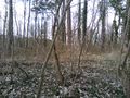
| + | Image:2018-03-31_49_8-2.jpg|25 m into this thorny path | ||
| + | Image:2018-03-31_49_8-7.jpg|proof | ||
| + | Image:2018-03-31_49_8-3.jpg|view to the west | ||
| + | Image:2018-03-31_49_8-4.jpg|to the north (and the path) | ||
| + | Image:2018-03-31_49_8-5.jpg|to the east | ||
| + | Image:2018-03-31_49_8-6.jpg|and to the south (nad the happy hasher) | ||
</gallery> | </gallery> | ||
| Line 45: | Line 57: | ||
{{#vardefine:ribbonwidth|800px}} | {{#vardefine:ribbonwidth|800px}} | ||
<!-- Add any achievement ribbons you earned below, or remove this section --> | <!-- Add any achievement ribbons you earned below, or remove this section --> | ||
| + | Just land today, but that may change tomorrow | ||
| + | {{land geohash | ||
| + | | latitude = 49 | ||
| + | | longitude = 8 | ||
| + | | date = 2018-03-31 | ||
| + | | name = DODO | ||
| + | }} | ||
| − | |||
| − | |||
| − | |||
| − | |||
| − | |||
| − | |||
| − | |||
| − | |||
| − | |||
| − | |||
| − | |||
| − | |||
| − | |||
[[Category:Expeditions]] | [[Category:Expeditions]] | ||
| − | |||
| − | |||
| − | |||
| − | |||
| − | |||
| − | |||
| − | |||
[[Category:Coordinates reached]] | [[Category:Coordinates reached]] | ||
| − | + | {{location|DE|BW|HD}} | |
| − | |||
| − | |||
| − | |||
| − | |||
| − | |||
| − | |||
| − | |||
| − | |||
| − | |||
| − | |||
| − | |||
| − | |||
| − | |||
| − | |||
| − | |||
| − | |||
| − | |||
Latest revision as of 03:26, 16 August 2019
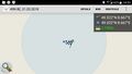
| Sat 31 Mar 2018 in 49,8: 49.3222345, 8.6667685 geohashing.info google osm bing/os kml crox |
Location
In a small peace of wood south of Sankt Ilgen.
Participants
Plans
Go there by bull in the afternoon. I have to do the shopping first, so I'm not sure, when I can start. Try to be there at hash o'clock. Will start soon (around 2 pm) and hope to arrive in an hour.
Expedition
Just a 2 hours ride and a 50 m walk in the warm sunny springtime.
Tracklog
Photos
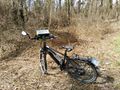
bull, 25 m apart
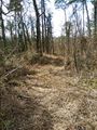
25 m into this thorny path
proof
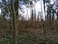
view to the west
to the north (and the path)
to the east

and to the south (nad the happy hasher)


Achievements
Just land today, but that may change tomorrow
DODO earned the Land geohash achievement
|