Difference between revisions of "2018-03-30 31 35"
imported>FippeBot m (Location) |
(→Expedition) |
||
| (3 intermediate revisions by 2 users not shown) | |||
| Line 29: | Line 29: | ||
Take the first bus westward and get off near Shoresh. | Take the first bus westward and get off near Shoresh. | ||
| + | |||
| + | I need to work fast because Passover is tonight. The morning before, we burn our last bread before we switch to Matzah so I have to do that before I go. | ||
== Expedition == | == Expedition == | ||
| − | The weather ended up being warm and rainy. It was pretty nice. | + | The weather ended up being warm and rainy. It was pretty nice. My timing was just fine before the holiday. |
I took the 185 from the Jerusalem city entrance to Neve Ilan, northeast of the hashpoint. From there someone guided me through his house to a trail that led to the tunnel underneath Highway One to the correct side of the highway. I walked around the village of Shoresh until I arrived at a trail. I followed Google Maps down the trail until I reached the closest point on the trail to the hashpoint before I would need to start bushwhacking. | I took the 185 from the Jerusalem city entrance to Neve Ilan, northeast of the hashpoint. From there someone guided me through his house to a trail that led to the tunnel underneath Highway One to the correct side of the highway. I walked around the village of Shoresh until I arrived at a trail. I followed Google Maps down the trail until I reached the closest point on the trail to the hashpoint before I would need to start bushwhacking. | ||
| Line 50: | Line 52: | ||
--> | --> | ||
<gallery perrow="5"> | <gallery perrow="5"> | ||
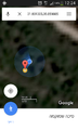
| + | Image: Screenshot 2018-03-30 31-35.png | Proof | ||
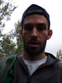
| + | Image: 20180330 122527.jpg | face | ||
</gallery> | </gallery> | ||
| Line 56: | Line 60: | ||
* Land Geohash | * Land Geohash | ||
| − | |||
| − | |||
| − | |||
| − | |||
Latest revision as of 22:38, 23 April 2020
| Fri 30 Mar 2018 in 31,35: 31.8013055, 35.0598847 geohashing.info google osm bing/os kml crox |
Location
In the forest west of Shoresh, Israel.
Participants
Plans
Take the first bus westward and get off near Shoresh.
I need to work fast because Passover is tonight. The morning before, we burn our last bread before we switch to Matzah so I have to do that before I go.
Expedition
The weather ended up being warm and rainy. It was pretty nice. My timing was just fine before the holiday.
I took the 185 from the Jerusalem city entrance to Neve Ilan, northeast of the hashpoint. From there someone guided me through his house to a trail that led to the tunnel underneath Highway One to the correct side of the highway. I walked around the village of Shoresh until I arrived at a trail. I followed Google Maps down the trail until I reached the closest point on the trail to the hashpoint before I would need to start bushwhacking.
Surprisingly bushwhacking was a lot harder than I thought. When I saw it was on a slope I tried to walk down below the slope so that I could attack at the unknown while walking up rather than walking down. There were small 1.5 meter terraces to climb and the foliage was thick enough that I had to crawl at some points. The GPS wasn't great quality so I had to do a lot of dancing, of course also on slopes and terraces. The hashpoint ended up being in a pleasant and I was able to get a screen shot and a selfie by the time my battery died.
I climbed back to the trail and then walked back to highway the way I came. Right before the entrance to the highway there was a gas station with plenty of drivers. I found someone who was going to Jerusalem and easily hitched back.
Tracklog
Photos
Coming soon...
Proof
face


Achievements
- Land Geohash