Difference between revisions of "2018-07-15 57 -6"
imported>AmritOfTheMaps (Created page with "{{subst:Expedition |lat = 57 |lon = -6 |date = 2018-07-15 }} ==Location== ==Participants== ==Plans== ==Expedition== ==Photos== ==Achievements==") |
(per Renaming Proposal) |
||
| (10 intermediate revisions by 4 users not shown) | |||
| Line 1: | Line 1: | ||
| − | <!-- If you did not specify these parameters in the template, please substitute appropriate values for IMAGE, LAT, LON, and DATE (YYYY-MM-DD format) | + | <!-- If you did not specify these parameters in the template, please substitute appropriate values for IMAGE, LAT, LON, and DATE (YYYY-MM-DD format)] |
| − | [[Image:{{{ | + | [[Image:{{{2018-07-15 57 -6 arrived.jpeg | Millicent, Vesper and Milwryaeth adventuring down the hill on the way back}}}|thumb|left]] |
Remove this section if you don't want an image at the top (left) of your report. You should remove the "Image:" or "File:" | Remove this section if you don't want an image at the top (left) of your report. You should remove the "Image:" or "File:" | ||
| Line 9: | Line 9: | ||
And DON'T FORGET to add your expedition and the best photo you took to the gallery on the Main Page! We'd love to read your report, but that means we first have to discover it! :) | And DON'T FORGET to add your expedition and the best photo you took to the gallery on the Main Page! We'd love to read your report, but that means we first have to discover it! :) | ||
--> | --> | ||
| + | |||
{{meetup graticule | {{meetup graticule | ||
| + | | map=<map lat="57" lon="-6" date="2018-07-15" /> | ||
| lat=57 | | lat=57 | ||
| lon=-6 | | lon=-6 | ||
| Line 19: | Line 21: | ||
== Location == | == Location == | ||
| − | + | A couple of miles south of Tarbert on the Isle of Harris | |
== Participants == | == Participants == | ||
| − | + | *[[User:milwryaeth|milwryaeth]] | |
| − | + | *[[User:AmritOfTheMaps|AmritOfTheMaps]] | |
| + | *Millicent | ||
| + | *Vesper | ||
== Plans == | == Plans == | ||
| − | + | We are staying at a holiday cottage on the Isle of Harris for a week and a bit, and thought we'd try geohashing, especially since it seems no-one's done it in the Outer Hebrides before! Today's location was gloriously near our cottage, about a mile away, so it didn't take much more planning than deciding to go, and then going. | |
== Expedition == | == Expedition == | ||
| − | + | Left our holiday cottage about 4pm, on a grey and wet day, but it wasn't actually raining at the time. The walk was about half a mile up the "Golden Road" and then a little more on the A859 before we'd have to leave the road. We walked slowly, stopping to admire such things as sheep, rocks, little lochs, wildflowers and amazing views (which constitute a lot of what there is to see on Harris). We left the road to walk the last few hundred yards to the coordinates, which were a fairly nondescript boggy patch of ground near a small stream and several large rocks, looking much like most of the West Coast of Harris does. | |
| + | |||
| + | Walked back by a different route, making our way down the hillside to the sea shore to meet the Tarbert-Miabhag footpath and going back home along that. | ||
| + | |||
== Tracklog == | == Tracklog == | ||
| Line 39: | Line 46: | ||
--> | --> | ||
<gallery perrow="5"> | <gallery perrow="5"> | ||
| + | Image:2018-07-15_57_-6_leaving.jpg | Setting off selfie! | ||
| + | Image:2018-07-15_57_-6_flowers.jpg | Milwryaeth admiring flowers in a little lochan | ||
| + | Image:2018-07-15_57_-6_pointing.jpg | AmritOfTheMaps points something out to Vesper | ||
| + | Image:2018-07-15_57_-6_road.jpg | Walking along the A859 | ||
| + | Image:2018-07-15_57_-6_sheep.jpg | A local resident of the woolly variety | ||
| + | Image:2018-07-15 57 -6 arrived.jpeg | Faces of joy having arrived at our destination! | ||
| + | Image:2018-07-15_57_-6_celebrating.jpg | Milwryaeth's pose of achievement shortly after reaching the hash | ||
| + | Image:2018-07-15_57_-6_face.jpg | AmritOfTheMaps's face at the hash point | ||
| + | Image:2018-07-15_57_-6_proof.jpg | Proof! | ||
| + | Image:2018-07-15_57_-6_hill.jpg | Millicent, Vesper and Milwryaeth adventuring down the hill to the footpath on the way back | ||
</gallery> | </gallery> | ||
| Line 45: | Line 62: | ||
<!-- Add any achievement ribbons you earned below, or remove this section --> | <!-- Add any achievement ribbons you earned below, or remove this section --> | ||
| − | + | {{land geohash | |
| − | |||
| − | |||
| − | |||
| − | |||
| − | |||
| − | |||
| − | |||
| − | |||
| − | |||
| − | |||
| − | |||
| − | + | | latitude = 57 | |
| − | + | | longitude = -6 | |
| − | -- and | + | | date = 2018-07-15 |
| − | + | | name = Milwryaeth and AmritOfTheMaps | |
| − | + | | image = 2018-07-15 57 -6 arrived.jpeg | |
| − | |||
| − | |||
| − | |||
| − | |||
| − | |||
| + | }} | ||
| − | + | {{Graticule unlocked | |
| − | |||
| − | |||
| − | |||
| − | |||
| − | |||
| − | |||
| − | |||
| − | + | | latitude = 57 | |
| − | + | | longitude = -6 | |
| − | + | | date = 2018-07-15 | |
| − | + | | name = Milwryaeth and AmritOfTheMaps | |
| − | + | | image = 2018-07-15 57 -6 arrived.jpeg | |
| − | + | }} | |
| − | |||
| − | == | + | <!-- =============== USEFUL CATEGORIES FOLLOW ================ |
| + | Delete the next line ONLY if you have chosen the appropriate categories below. If you are unsure, don't worry. People will read your report and help you with the classification. --> | ||
| − | == | + | <!-- ==REQUEST FOR TWITTER BOT== Please leave either the New report or the Expedition planning category in as long as you work on it. This helps the twitter bot a lot with announcing the right outcome at the right moment. --> |
| − | |||
| − | + | [[Category:Expeditions]] | |
| − | + | [[Category:Expeditions with photos]] | |
| − | + | [[Category:Coordinates reached]] | |
| + | [[Category:Land_geohash_achievement]] | ||
| + | [[Category:Graticule unlocked achievement]] | ||
| + | {{location|GB|SCT|ELS}} | ||
Latest revision as of 03:07, 20 March 2024
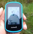
| Sun 15 Jul 2018 in 57,-6: 57.8757748, -6.8170045 geohashing.info google osm bing/os kml crox |
Location
A couple of miles south of Tarbert on the Isle of Harris
Participants
- milwryaeth
- AmritOfTheMaps
- Millicent
- Vesper
Plans
We are staying at a holiday cottage on the Isle of Harris for a week and a bit, and thought we'd try geohashing, especially since it seems no-one's done it in the Outer Hebrides before! Today's location was gloriously near our cottage, about a mile away, so it didn't take much more planning than deciding to go, and then going.
Expedition
Left our holiday cottage about 4pm, on a grey and wet day, but it wasn't actually raining at the time. The walk was about half a mile up the "Golden Road" and then a little more on the A859 before we'd have to leave the road. We walked slowly, stopping to admire such things as sheep, rocks, little lochs, wildflowers and amazing views (which constitute a lot of what there is to see on Harris). We left the road to walk the last few hundred yards to the coordinates, which were a fairly nondescript boggy patch of ground near a small stream and several large rocks, looking much like most of the West Coast of Harris does.
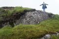
Walked back by a different route, making our way down the hillside to the sea shore to meet the Tarbert-Miabhag footpath and going back home along that.
Tracklog
Photos
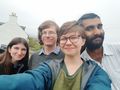
Setting off selfie!
Milwryaeth admiring flowers in a little lochan
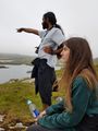
AmritOfTheMaps points something out to Vesper
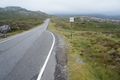
Walking along the A859
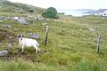
A local resident of the woolly variety
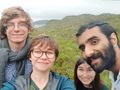
Faces of joy having arrived at our destination!
Milwryaeth's pose of achievement shortly after reaching the hash
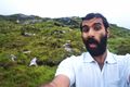
AmritOfTheMaps's face at the hash point
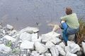
Proof!
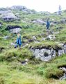
Millicent, Vesper and Milwryaeth adventuring down the hill to the footpath on the way back


Achievements
Milwryaeth and AmritOfTheMaps earned the Land geohash achievement
|
Milwryaeth and AmritOfTheMaps earned the Graticule Unlocked Achievement
|