Difference between revisions of "2018-07-27 28 -80"
imported>DrCanadianNinja (Created page with "{{meetup graticule | map=<map lat="28" lon="-80" date="2018-07-27" /> | lat=28 | lon=-80 | date=2018-07-27 | graticule_name=Edgewater, Florida | graticule_link=Melbourne, Flor...") |
m |
||
| (5 intermediate revisions by 2 users not shown) | |||
| Line 1: | Line 1: | ||
| + | {{Advert}} | ||
| + | |||
{{meetup graticule | {{meetup graticule | ||
| map=<map lat="28" lon="-80" date="2018-07-27" /> | | map=<map lat="28" lon="-80" date="2018-07-27" /> | ||
| Line 15: | Line 17: | ||
=== The Geohashers === | === The Geohashers === | ||
| − | * [[user: | + | * [[user:Geoffistopheles|Geoff]] |
=== The Adventure === | === The Adventure === | ||
| − | + | This was my first real test of my medication after over a year. One of the reasons I stopped geohashing was that I couldn't travel for very long without a form of panic attacks. I had verified it in shorter trips, but how would it hold up when driving for an hour at a time? Wonderfully, as it turns out. I was able to get a largely stress-free ride out of it. | |
| + | |||
| + | I hadn't taken too much effort in planning, nor did I set up a GPS to begin with, so I was glad I at least remembered the exit. From there, the problem was a grid layout combined with similar street names, compounded by seeing police pull someone over near my turn. One wrong turn was thankfully easily solved without getting back on the main road, and I proceeded to Mango Tree Drive. From there, I snapped a few pictures, did the geohash dance, and turned back around, largely because I noticed someone had a fondness for model lighthouses. Not the first time I've heard of that, but the first time I've seen them proudly displayed outside. I approve! | ||
| + | |||
| + | Also, that lack of planning thing was a bit of a lie. I did some looking around on the map earlier and noticed that Edgewater Public Library was within a mile. I stopped in there to leave the marker, but not before taking a good look around. The entire place made me step back twenty years. They had the old-fashioned maps, not the ones that fold out, but the giant wall covering ones. It reminded me of my dad using the huge foldouts to plot a flight. The library itself looked like so many others, but still took me back to a time when I regularly visited. | ||
| + | |||
| + | On the way back, I merged into a lane and had a bit of a heart attack; an 18-wheeler was being towed, and I have to say, that is ''not'' something you want to see when merging. | ||
| + | |||
| + | === Gallery === | ||
| + | <gallery caption="Photo Gallery" widths="200px" heights="200px" perrow="4"> | ||
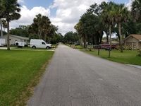
| + | Image:2018-07-27_28_-80_GeohashNW.jpg|Looking northwest up Mango Tree Drive. | ||
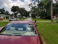
| + | Image:2018-07-27_28_-80_GeohashSE.jpg|Looking southeast down Mango Tree Drive. | ||
| + | Image:2018-07-27_28_-80_GPS.jpg| | ||
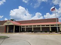
| + | Image:2018-07-27_28_-80_Library.jpg|The nearby public library. | ||
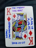
| + | Image:2018-07-27_28_-80_Marker.jpg|K♦ | ||
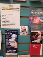
| + | Image:2018-07-27_28_-80_MarkerLocation.jpg|Left on the event board. | ||
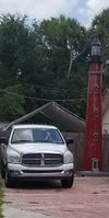
| + | Image:2018-07-27_28_-80_Lighthouse1.jpg|Model lighthouses! | ||
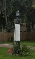
| + | Image:2018-07-27_28_-80_Lighthouse2.jpg| | ||
| + | Image:2018-07-27_28_-80_Geohasher.jpg|Only remembered to take this at the end. | ||
| + | Image:2018-07-27_28_-80_OHGOD.jpg|OH GOD IT'S being towed. Oh. | ||
| + | </gallery> | ||
| + | |||
| + | === Achieveables === | ||
| + | Doubling down on the minesweeper, this one completes a 3x4 grid! | ||
| + | |||
| + | {{Minesweeper geohash | ||
| + | | graticule = Orlando, Florida | ||
| + | | ranknumber = 8 | ||
| + | | nw = true | ||
| + | | n = true | ||
| + | | ne = true | ||
| + | | w = true | ||
| + | | e = true | ||
| + | | sw = true | ||
| + | | s = true | ||
| + | | se = true | ||
| + | | name = [[user:Geoffistopheles|Geoff]] | ||
| + | }} | ||
| + | {{Minesweeper geohash | ||
| + | | graticule = Sebring, Florida | ||
| + | | ranknumber = 8 | ||
| + | | nw = true | ||
| + | | n = true | ||
| + | | ne = true | ||
| + | | w = true | ||
| + | | e = true | ||
| + | | sw = true | ||
| + | | s = true | ||
| + | | se = true | ||
| + | | name = [[user:Geoffistopheles|Geoff]] | ||
| + | }} | ||
[[Category:Meetup on 2018-07-27]] | [[Category:Meetup on 2018-07-27]] | ||
[[Category:Meetup in 28 -80]] | [[Category:Meetup in 28 -80]] | ||
[[Category:Expeditions]] | [[Category:Expeditions]] | ||
| + | [[Category:Coordinates reached]] | ||
| + | [[Category:Expeditions with photos]] | ||
| + | {{location|US|FL|VO}} | ||
Latest revision as of 17:13, 24 March 2021
| Have you seen our geohashing marker? We'd love to hear from you! Click here to say "hi" and tell us what you've seen!
Curious about what geohashing is? Read more! |
| Fri 27 Jul 2018 in Edgewater, Florida: 28.9690934, -80.9076041 geohashing.info google osm bing/os kml crox |
Contents
Expedition
The Plan
On Mango Tree Drive near the Edgewater Public Library. Get on 95 southbound for about a hundred miles, easy peasy. Probably won't go for Speed Racer, given it's summer, school's out, and kids may be playing outside. Plus, this one's just me and trying to prove that I was doing the speed limit while taking pictures as proof isn't even a debatable bad idea, just a genuine bad idea.
As soon as I realized this was a reachable hash on a day I could actually afford to drop everything to drive an hour and a half, I was on board. After all, it's not every day you get the opportunity to complete not just one minesweeper, but two.
The Geohashers
The Adventure
This was my first real test of my medication after over a year. One of the reasons I stopped geohashing was that I couldn't travel for very long without a form of panic attacks. I had verified it in shorter trips, but how would it hold up when driving for an hour at a time? Wonderfully, as it turns out. I was able to get a largely stress-free ride out of it.
I hadn't taken too much effort in planning, nor did I set up a GPS to begin with, so I was glad I at least remembered the exit. From there, the problem was a grid layout combined with similar street names, compounded by seeing police pull someone over near my turn. One wrong turn was thankfully easily solved without getting back on the main road, and I proceeded to Mango Tree Drive. From there, I snapped a few pictures, did the geohash dance, and turned back around, largely because I noticed someone had a fondness for model lighthouses. Not the first time I've heard of that, but the first time I've seen them proudly displayed outside. I approve!
Also, that lack of planning thing was a bit of a lie. I did some looking around on the map earlier and noticed that Edgewater Public Library was within a mile. I stopped in there to leave the marker, but not before taking a good look around. The entire place made me step back twenty years. They had the old-fashioned maps, not the ones that fold out, but the giant wall covering ones. It reminded me of my dad using the huge foldouts to plot a flight. The library itself looked like so many others, but still took me back to a time when I regularly visited.
On the way back, I merged into a lane and had a bit of a heart attack; an 18-wheeler was being towed, and I have to say, that is not something you want to see when merging.
Gallery
- Photo Gallery
Achieveables
Doubling down on the minesweeper, this one completes a 3x4 grid!
Geoff completed the Minesweeper Geohash achievement
|
Geoff completed the Minesweeper Geohash achievement
|
