Difference between revisions of "2018-09-04 30 -82"
imported>DrCanadianNinja (Created page with "{{meetup graticule | map=<map lat="30" lon="-82" date="2018-09-04" /> | lat=30 | lon=-82 | date=2018-09-04 | graticule_name=Lake Butler, Florida | graticule_link=Lake City, Fl...") |
m |
||
| (3 intermediate revisions by 2 users not shown) | |||
| Line 13: | Line 13: | ||
=== The Geohashers === | === The Geohashers === | ||
| − | * [[user: | + | * [[user:Geoffistopheles|Geoff]] |
=== The Adventure === | === The Adventure === | ||
| Line 25: | Line 25: | ||
== Gallery == | == Gallery == | ||
| − | + | <gallery caption="Photo Gallery" widths="200px" heights="200px" perrow="3"> | |
| + | Image:2018-09-04_30_-82_Geohash.jpg|Quick shot before running back. | ||
| + | Image:2018-09-04_30_-82_Geohasher.jpg|Waited to take this by the car, some of the bugs were still following me. | ||
| + | Image:2018-09-04_30_-82_GPS.jpg|I was already getting swarmed by here, so I just said good enough. | ||
| + | </gallery> | ||
== Achieveables == | == Achieveables == | ||
| Line 34: | Line 38: | ||
| latitude = 30 | | latitude = 30 | ||
| longitude = -84 | | longitude = -84 | ||
| − | | date = | + | | date = 2018-09-02 |
| − | | name = [[user: | + | | name = [[user:Geoffistopheles|Geoff]] |
}} | }} | ||
[[Category:Expeditions]] | [[Category:Expeditions]] | ||
[[Category:Coordinates reached]] | [[Category:Coordinates reached]] | ||
| + | [[Category:Expeditions with photos]] | ||
| + | {{location|US|FL|UN}} | ||
Latest revision as of 17:14, 24 March 2021
| Tue 4 Sep 2018 in Lake Butler, Florida: 30.1196880, -82.3801656 geohashing.info google osm bing/os kml crox |
Expedition
The Plan
Just off County Road 231. Looks to be just off a back road.
The Geohashers
The Adventure
Normally, I don't think I'd do this one. I was just writing up YESTERDAY that going offroad is usually a bad sign. That was without hubris, a new county, and a new consecutive geohashing personal best hanging over my head.
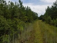
So, to get that out of the way, there was a gate on the road now. On the other hand, you wouldn't have seen the road at all if you weren't explicitly looking for it. It was no longer a dirt road and was instead overtaken by weeds. The gate and the lock on the gate were rusted. I was getting more of the impression of abandonment than private property. So I sidled around the gate and figured I had 100 meters to the hash point. Not my proudest decision making moment ever.
That leads to an unmentioned reason why I normally don't do these - it's September in Florida. I don't know what I stepped in or what I disturbed, but there was one large, buzzing bug flying around my head. Okay, fine, he's just being a pain. Then another joined in. I jogged to the hash point, took a picture and a screenshot. Then a third joined in and I decided it was time to hightail it back to the car. Mother Nature was particularly displeased with my decision making.
All in all, I wouldn't recommend it, and it seems like it's just the kind of mistake I need to make every few years to remind me why I don't do that.
Gallery
- Photo Gallery
Achieveables
Geoff earned the Consecutive geohash achievement
|


