Difference between revisions of "2018-12-31 45 -89"
From Geohashing
imported>WausauBill (→Photos) |
(per Renaming Proposal) |
||
| (3 intermediate revisions by 2 users not shown) | |||
| Line 42: | Line 42: | ||
Image:2018-12-31_45_-89_WausauBill_Proof.png | Actual proof! | Image:2018-12-31_45_-89_WausauBill_Proof.png | Actual proof! | ||
</gallery> | </gallery> | ||
| + | |||
| + | ==Ribbons== | ||
| + | |||
| + | {{Graticule unlocked | ||
| + | | latitude = 45 | ||
| + | | longitude = -89 | ||
| + | | date = 2018-12-31 | ||
| + | | name = WausauBill | ||
| + | }} | ||
| + | |||
| + | [[Category:Expeditions]] | ||
| + | [[Category:Expeditions with photos]] | ||
| + | [[Category:Coordinates reached]] | ||
| + | {{location|US|WI|LN}} | ||
Latest revision as of 11:30, 20 March 2024
| Mon 31 Dec 2018 in 45,-89: 45.2328777, -89.3117524 geohashing.info google osm bing/os kml crox |
Location
County Rd H, Deerbrook, WI (According to Google Maps)
Participants
Just little ole me WausauBill (talk)
Plans
Saw that the hash was by the side of the road (I was hoping it was in the road, but no such luck!) not terribly far from the house, so I drove on out and continued to the next town, did a little shopping and headed back home before the snow flew.
Expedition
Oh, seems I put the whole expedition in the plans section.
Close enough!
Photos
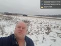
Out in the field @45.2328,-89.3118
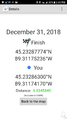
Actual proof!


Ribbons
WausauBill earned the Graticule Unlocked Achievement
|