Difference between revisions of "2019-02-11 50 18"
From Geohashing
imported>K2l8m11n2 (Created page with "{{subst:Expedition |lat = 50 |lon = 18 |date = 2019-02-11 }}") |
(Removed selfies for privacy) |
||
| (11 intermediate revisions by 2 users not shown) | |||
| Line 20: | Line 20: | ||
== Location == | == Location == | ||
<!-- where you've surveyed the hash to be --> | <!-- where you've surveyed the hash to be --> | ||
| + | A field near Żernica. | ||
== Participants == | == Participants == | ||
<!-- who attended: If you link to your wiki user name in this section, your expedition will be picked up by the various statistics generated for geohashing. You may use three tildes ~ as a shortcut to automatically insert the user signature of the account you are editing with. | <!-- who attended: If you link to your wiki user name in this section, your expedition will be picked up by the various statistics generated for geohashing. You may use three tildes ~ as a shortcut to automatically insert the user signature of the account you are editing with. | ||
--> | --> | ||
| + | [[User:K2l8m11n2|k2l8m11n2]] | ||
== Plans == | == Plans == | ||
<!-- what were the original plans --> | <!-- what were the original plans --> | ||
| + | The original plan was to set off at 11 but various circumstances pushed it to 19. | ||
== Expedition == | == Expedition == | ||
<!-- how it all turned out. your narrative goes here. --> | <!-- how it all turned out. your narrative goes here. --> | ||
| + | Took a train to Gliwice through Katowice at 19, walked the rest of the way there. | ||
| + | I managed to reach the point just a few minutes before midnight. | ||
| + | Had to wait (tired, wet and sleepy) until the first train at 4 when going back. | ||
== Tracklog == | == Tracklog == | ||
| Line 39: | Line 45: | ||
--> | --> | ||
<gallery perrow="5"> | <gallery perrow="5"> | ||
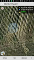
| + | Image:2019-02-11 50 18 proof.png | Proof of reaching the point | ||
| + | Image:2019-02-11 50 18 map.png | ||
| + | Image:2019-02-11 50 18 site.jpg | Surroundings of the site | ||
| + | Image:2019-02-11 50 18 lights.jpg | Pretty lights on the overpass | ||
</gallery> | </gallery> | ||
| Line 47: | Line 57: | ||
<!-- =============== USEFUL CATEGORIES FOLLOW ================ | <!-- =============== USEFUL CATEGORIES FOLLOW ================ | ||
Delete the next line ONLY if you have chosen the appropriate categories below. If you are unsure, don't worry. People will read your report and help you with the classification. --> | Delete the next line ONLY if you have chosen the appropriate categories below. If you are unsure, don't worry. People will read your report and help you with the classification. --> | ||
| − | |||
<!-- ==REQUEST FOR TWITTER BOT== Please leave either the New report or the Expedition planning category in as long as you work on it. This helps the twitter bot a lot with announcing the right outcome at the right moment. --> | <!-- ==REQUEST FOR TWITTER BOT== Please leave either the New report or the Expedition planning category in as long as you work on it. This helps the twitter bot a lot with announcing the right outcome at the right moment. --> | ||
| Line 58: | Line 67: | ||
<!-- If all those plans are never acted upon, change [[Category:Expedition planning]] to [[Category:Not reached - Did not attempt]]. --> | <!-- If all those plans are never acted upon, change [[Category:Expedition planning]] to [[Category:Not reached - Did not attempt]]. --> | ||
| − | |||
[[Category:Expeditions]] | [[Category:Expeditions]] | ||
| − | |||
[[Category:Expeditions with photos]] | [[Category:Expeditions with photos]] | ||
| − | |||
| − | |||
| − | |||
| − | |||
| − | |||
| − | <!-- if you reached your coords: | + | <!-- if you reached your coords: --> |
[[Category:Coordinates reached]] | [[Category:Coordinates reached]] | ||
| − | + | <!-- or if you failed :( | |
[[Category:Coordinates not reached]] | [[Category:Coordinates not reached]] | ||
-- and a reason -- | -- and a reason -- | ||
| Line 88: | Line 90: | ||
(Don't forget to delete this final close comment marker) --> | (Don't forget to delete this final close comment marker) --> | ||
| + | |||
| + | {{land geohash | ||
| + | |||
| + | | latitude = 50 | ||
| + | | longitude = 18 | ||
| + | | date = 2019-02-11 | ||
| + | | name = k2l8m11n2 | ||
| + | }} | ||
| + | |||
| + | {{Midnight geohash | ||
| + | |||
| + | | latitude = 50 | ||
| + | | longitude = 18 | ||
| + | | date = 2019-02-11 | ||
| + | | name = k2l8m11n2 | ||
| + | }} | ||
| + | |||
| + | {{Public transport geohash | ||
| + | |||
| + | | latitude = 50 | ||
| + | | longitude = 18 | ||
| + | | date = 2019-02-11 | ||
| + | | name = k2l8m11n2 | ||
| + | }} | ||
| + | {{location|PL|S|GL}} | ||
Latest revision as of 23:08, 16 May 2020
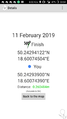
| Mon 11 Feb 2019 in 50,18: 50.2429412, 18.6007450 geohashing.info google osm bing/os kml crox |
Location
A field near Żernica.
Participants
Plans
The original plan was to set off at 11 but various circumstances pushed it to 19.
Expedition
Took a train to Gliwice through Katowice at 19, walked the rest of the way there. I managed to reach the point just a few minutes before midnight. Had to wait (tired, wet and sleepy) until the first train at 4 when going back.
Tracklog
Photos
Proof of reaching the point
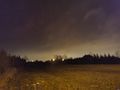
Surroundings of the site
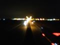
Pretty lights on the overpass


Achievements
k2l8m11n2 earned the Land geohash achievement
|
k2l8m11n2 earned the Midnight Geohash achievement
|
k2l8m11n2 earned the Public transport geohash achievement
|