Difference between revisions of "2019-05-02 50 20"
imported>Omnimusician (Created page with "{{subst:Expedition |lat = 50 |lon = 20 |date = 2019-05-02 }}") |
imported>Fippe m (more precise location) |
||
| (8 intermediate revisions by 2 users not shown) | |||
| Line 15: | Line 15: | ||
}} | }} | ||
| − | + | ||
__NOTOC__ | __NOTOC__ | ||
== Location == | == Location == | ||
| − | + | Niepołomice Forest, Lesser Poland Voidevodeship, Poland. | |
== Participants == | == Participants == | ||
| − | + | Two musicians – | |
| − | + | * [[User:Omnimusician|Omnimusician]] with | |
| + | * girlfriend. | ||
== Plans == | == Plans == | ||
| − | + | My friend told me about geohashing. Like 10 years ago. Just a few days ago I remembered this activity and realised I became crazy enough to enjoy it. I also took my girlfriend, because her craziness and love for weird stuff matches my own. Now it's a ''long weekend'' for we've got public holidays and it was the perfect time to stard geohashing! | |
== Expedition == | == Expedition == | ||
| − | + | I live in Kraków, which is a transport hub for our region, but my girlfriend makes it from slightly remote village and travelling by train is her daily routine, and her train would take us to the destination, so I just joined her in that train. | |
| + | |||
| + | Soon we got out in Staniątki. The station was just a walk from the hash. We came along the tracks and a memorial slab indicated turning point. (The slab remembers blasting a nazi-german train, #justpolandthings). | ||
| + | |||
| + | Then we got into the forest. The hash was just several meters away from the path. Unfortunately just after reaching a stump we supposed to be the point, our devices lost signal quality and went crazy, so the assumed point was ''travelling'' around us. Nevertheless, after standing still for a several minutes, each of them confirmed at least for a while we actually got there. | ||
== Tracklog == | == Tracklog == | ||
| − | + | ''nope'' | |
== Photos == | == Photos == | ||
| − | |||
| − | |||
| − | |||
<gallery perrow="5"> | <gallery perrow="5"> | ||
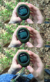
| + | 2019-05-02 50 20 001.png|GPS not sure if we are on the spot indeed | ||
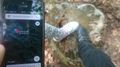
| + | 2019-05-02 50 20 003.PNG|iPhone screenshot confirming we were at least next to the spot | ||
| + | 2019-05-02 50 20 002.JPG|Memorial slab<br>''Here on 1944-01.29 sabotage group of National Army assassinated the train with general governor Hans Frank onboard'' | ||
| + | 2019-05-02 50 20 005.png|Hardware GPS being more stable than software relying on GSM… | ||
| + | 2019-05-02 50 20 004.jpg|…but the later one managed to tighten the probability radius for a moment. | ||
</gallery> | </gallery> | ||
== Achievements == | == Achievements == | ||
{{#vardefine:ribbonwidth|800px}} | {{#vardefine:ribbonwidth|800px}} | ||
| − | + | {{Public transport geohash | |
| − | + | | latitude = 50 | |
| − | + | | longitude = 20 | |
| − | + | | date = 2019-05-02 | |
| − | [[ | + | | busline = PolRegio (train) |
| − | + | | name = [[User:Omnimusician|Omnimusician]] | |
| − | + | }} | |
| − | + | {{drag-along | |
| − | + | | latitude = 50 | |
| − | + | | longitude = 20 | |
| − | [[ | + | | date = 2019-05-02 |
| − | + | | partner = My GF | |
| + | | name = [[user:Omnimusician|Omnimusician]] | ||
| + | }} | ||
| − | |||
| − | |||
| − | |||
[[Category:Expeditions]] | [[Category:Expeditions]] | ||
| − | |||
[[Category:Expeditions with photos]] | [[Category:Expeditions with photos]] | ||
| − | |||
| − | |||
| − | |||
| − | |||
| − | |||
| − | |||
| − | |||
[[Category:Coordinates reached]] | [[Category:Coordinates reached]] | ||
| − | + | {{location|PL|K|WI}} | |
| − | |||
| − | |||
| − | |||
| − | |||
| − | |||
| − | |||
| − | |||
| − | |||
| − | |||
| − | |||
| − | |||
| − | |||
| − | |||
| − | |||
| − | |||
| − | |||
Latest revision as of 14:37, 24 July 2019
| Thu 2 May 2019 in 50,20: 50.0075044, 20.2263195 geohashing.info google osm bing/os kml crox |
Location
Niepołomice Forest, Lesser Poland Voidevodeship, Poland.
Participants
Two musicians –
- Omnimusician with
- girlfriend.
Plans
My friend told me about geohashing. Like 10 years ago. Just a few days ago I remembered this activity and realised I became crazy enough to enjoy it. I also took my girlfriend, because her craziness and love for weird stuff matches my own. Now it's a long weekend for we've got public holidays and it was the perfect time to stard geohashing!
Expedition
I live in Kraków, which is a transport hub for our region, but my girlfriend makes it from slightly remote village and travelling by train is her daily routine, and her train would take us to the destination, so I just joined her in that train.
Soon we got out in Staniątki. The station was just a walk from the hash. We came along the tracks and a memorial slab indicated turning point. (The slab remembers blasting a nazi-german train, #justpolandthings).
Then we got into the forest. The hash was just several meters away from the path. Unfortunately just after reaching a stump we supposed to be the point, our devices lost signal quality and went crazy, so the assumed point was travelling around us. Nevertheless, after standing still for a several minutes, each of them confirmed at least for a while we actually got there.
Tracklog
nope
Photos
GPS not sure if we are on the spot indeed
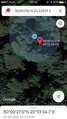
iPhone screenshot confirming we were at least next to the spot
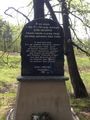
Memorial slab
Here on 1944-01.29 sabotage group of National Army assassinated the train with general governor Hans Frank onboard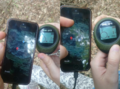
Hardware GPS being more stable than software relying on GSM…
…but the later one managed to tighten the probability radius for a moment.


Achievements
Omnimusician earned the Public transport geohash achievement
|
Omnimusician earned the Drag-along achievement
|