Difference between revisions of "2018-02-10 53 -2"
From Geohashing
(→Photos: add some old photos from that day) |
m (→Achievements: add Category:Expeditions back in) |
||
| (3 intermediate revisions by the same user not shown) | |||
| Line 19: | Line 19: | ||
== Location == | == Location == | ||
| − | + | Right on the pavement just outside local transport hub Picadilly Station. Hashpoints don't get much easier than this. | |
== Participants == | == Participants == | ||
| − | + | * [[User:KarMann|KarMann]] | |
| − | |||
| − | |||
== Plans == | == Plans == | ||
| Line 54: | Line 52: | ||
[[Category:Expeditions]] | [[Category:Expeditions]] | ||
| + | [[Category:Expeditions with photos]] | ||
[[Category:Coordinates reached]] | [[Category:Coordinates reached]] | ||
{{location|GB|ENG|MAN}} | {{location|GB|ENG|MAN}} | ||
Latest revision as of 03:55, 6 February 2020
| Sat 10 Feb 2018 in 53,-2: 53.4780175, -2.2321579 geohashing.info google osm bing/os kml crox |
Location
Right on the pavement just outside local transport hub Picadilly Station. Hashpoints don't get much easier than this.
Participants
Plans
Expedition
Tracklog
Photos
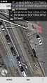
Hash achieved, though GPS is a bit off here. @53.4779,-2.2324
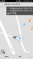
And now I'm properly there.
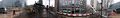
360° view from the hashpoint just outside Picadilly Station

