Difference between revisions of "2020-02-24 38 -76"
(Created page with "{{meetup graticule | lat=38 | lon=-77 | date=2019-09-06}} == Location == Just off Route 202 in a small forest near Largo. == Participants == *Ipswichb...") |
|||
| (3 intermediate revisions by 2 users not shown) | |||
| Line 1: | Line 1: | ||
| − | {{meetup graticule | lat=38 | lon=- | + | {{meetup graticule | lat=38 | lon=-76 | date=2020-02-24}} |
== Location == | == Location == | ||
| Line 16: | Line 16: | ||
== Photos == | == Photos == | ||
<gallery perrow="7"> | <gallery perrow="7"> | ||
| + | Image: Hashpoint 2-24-20.jpg|View from the hashpoint overlooking the pond | ||
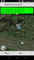
| + | Image: Proof 2-24-20.png|Proof | ||
| + | </gallery> | ||
| − | + | == Achievements == | |
| + | {{Multihash | ||
| + | |||
| + | | latitude1 = 39 | ||
| + | | longitude1 = -76 | ||
| + | | latitude2 = 41 | ||
| + | | longitude2 = -72 | ||
| + | | date = 2020-04-01 | ||
| + | | name = Ipswichb | ||
| + | | image = 04-01-20 Hashpoint.jpg | ||
| + | }} | ||
| Line 26: | Line 39: | ||
[[Category:Coordinates reached]] | [[Category:Coordinates reached]] | ||
[[Category:Expeditions with photos]] | [[Category:Expeditions with photos]] | ||
| − | {{location|US| | + | {{location|US|MD|PR}} |
Latest revision as of 15:41, 2 April 2020
| Mon 24 Feb 2020 in 38,-76: 38.8762543, -76.7997395 geohashing.info google osm bing/os kml crox |
Location
Just off Route 202 in a small forest near Largo.
Participants
Expedition
It's been a few weeks since the end of the Dark Ages, and I had yet to make an expedition before today. So, I figured it was time to get one in the books! This one wasn't far from where I work, so after work I headed over to the point.
I started in the nearby subdivision, but seeking to avoid a longer walk along the busy highway, I headed west through the woods and under the power lines before my progress was stopped by a large river. It was clear I couldn't go through the water without getting my feet soaked, so I scrambled up the embankment to the highway, crossed the river on the bridge, and then walked down the embankment on the West side of the river. From there it was a short and easy walk. The hashpoint lay right on the shore of a small pond - I had to stand on a fortunately-placed log to reach the coordinates.
From there, I walked back up to the highway and took a bus to the closest Metro station and back home!
Photos
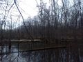
View from the hashpoint overlooking the pond
Proof


Achievements
Ipswichb earned the Multihash Achievement
|