Difference between revisions of "2010-05-22 28 -105"
From Geohashing
(Source: User:Fede) |
m (per Renaming Proposal) |
||
| (One intermediate revision by one other user not shown) | |||
| Line 41: | Line 41: | ||
}} | }} | ||
| − | {{ | + | {{Graticule unlocked |
| latitude = 28 | | latitude = 28 | ||
| Line 62: | Line 62: | ||
[[Category:Expeditions]] | [[Category:Expeditions]] | ||
[[Category:Coordinates reached]] | [[Category:Coordinates reached]] | ||
| + | {{location|MX|CHH}} | ||
Latest revision as of 06:13, 20 March 2024
| Sat 22 May 2010 in 28,-105: 28.4635260, -105.7646015 geohashing.info google osm bing/os kml crox |
Location
This Geohash is located near El Ojito.
Participants
- Fede
- Marco
- Paz
Expedition
Probably the first group to do this in Mexico.
Photos
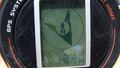
Proof

Ribbons
Fede earned the 2010 Mouse Over Day achievement
|
Fede earned the Land geohash achievement
|
Fede earned the Graticule Unlocked Achievement
|
Fede earned the Drag-along achievement
|