Difference between revisions of "2020-04-19 49 8"
(Created page with "{{subst:Expedition |lat = 49 |lon = 8 |date = 2020-04-19}}") |
|||
| (4 intermediate revisions by 2 users not shown) | |||
| Line 1: | Line 1: | ||
| − | + | {{meetup graticule | |
| − | |||
| − | |||
| − | |||
| − | |||
| − | |||
| − | |||
| − | |||
| − | |||
| lat=49 | | lat=49 | ||
| lon=8 | | lon=8 | ||
| Line 13: | Line 5: | ||
}}<!-- edit as necessary --> | }}<!-- edit as necessary --> | ||
__NOTOC__ | __NOTOC__ | ||
| + | |||
| + | [[2020-04-12_49_8|previous]] [[2020-04-25 49 8|next]] | ||
| + | |||
== Location == | == Location == | ||
<!-- where you've surveyed the hash to be --> | <!-- where you've surveyed the hash to be --> | ||
| − | + | In a wilderness on the (pen)insula Flötzgrün near Mechtersheim. | |
== Participants == | == Participants == | ||
<!-- who attended: If you link to your wiki user name in this section, your expedition will be picked up by the various statistics generated for geohashing. You may use three tildes ~ as a shortcut to automatically insert the user signature of the account you are editing with. | <!-- who attended: If you link to your wiki user name in this section, your expedition will be picked up by the various statistics generated for geohashing. You may use three tildes ~ as a shortcut to automatically insert the user signature of the account you are editing with. | ||
--> | --> | ||
| − | + | [[User:DODO|DODO]] | |
== Plans == | == Plans == | ||
<!-- what were the original plans --> | <!-- what were the original plans --> | ||
| − | + | So close to home, sunday, sunny weather, spring. What else would it need to go to this hash? I decided to wlak by foot. | |
== Expedition == | == Expedition == | ||
<!-- how it all turned out. your narrative goes here. --> | <!-- how it all turned out. your narrative goes here. --> | ||
| + | I started from home t10:45. I walked through the town for half an hour, but then I reached the fields. Short time later I reached the rhine dike and some minutes later I crossed the dike and walked on the dam that connects the peninsula Flötzgrün with the mainland. | ||
| + | As I had to cross this dam twice, I couldn't reach a tron achievement. The island is covered wirth an alluvial forest and it was wonderful to walk there. There were a fantastillion birds singing. Half an hour later I left the mainpath and switched left to a smaller path. Soon I reached a lawn. According to Google there should be a path on the other side of the lawn, but there was just wilderness. I still had to go 70 m and I was up to call it a failure. But then I saw the water just next to the lawn and a walkable shore next to it. So I climbed down a small bank and followed the water for some meters. I came down to 35m. It was still just wilderness ebtween me and the hash, but it doesn't seem as dense as from the lawn-side. So I climbed the bank again and fought myself through some stinging-nettles. Thanks to good shoes and a dense trouser (which Ioffended me earlier for beeing to warm) I could cross the copse, althoug slowly. After some minutes I had a success. A tree stand just at the right point. Just some pictures, than I returned. As I could use my own path, the way back was much faster. | ||
| + | |||
| + | The rest of the way was rather uneventfull (except for an icecream at the gs station). After 3 hours I came back home. | ||
== Tracklog == | == Tracklog == | ||
<!-- if your GPS device keeps a log, you may post a link here --> | <!-- if your GPS device keeps a log, you may post a link here --> | ||
| − | + | [https://www.komoot.de/tour/173156865 14 km by foot] | |
== Photos == | == Photos == | ||
<!-- Insert pictures between the gallery tags using the following format: | <!-- Insert pictures between the gallery tags using the following format: | ||
| Line 34: | Line 33: | ||
--> | --> | ||
<gallery perrow="5"> | <gallery perrow="5"> | ||
| + | File:2020-04-19_49_01.jpg|Everything is going to be alright. | ||
| + | File:2020-04-19_49_02.jpg|blossom (broom this time) | ||
| + | File:2020-04-19_49_06.jpg|the water (oxbow) | ||
| + | File:2020-04-19_49_08.jpg|google says there is a path | ||
| + | File:2020-04-19_49_09.jpg|along the shore | ||
| + | File:Screenshot_20200419-122222.png|still 35 m to go | ||
| + | File:2020-04-19_49_10.jpg|doesn't look much better, but was manageable | ||
| + | File:Screenshot_20200419-122723.png|proof | ||
| + | File:2020-04-19_49_11.jpg|hashtree (west) | ||
| + | File:2020-04-19_49_12.jpg|south | ||
| + | File:2020-04-19_49_13.jpg|east | ||
| + | File:2020-04-19_49_14.jpg|and north | ||
| + | File:2020-04-19_49_17.jpg|happy hasher | ||
| + | File:2020-04-19_49_19.jpg|mussels (at the shore on my way back) | ||
</gallery> | </gallery> | ||
== Achievements == | == Achievements == | ||
{{#vardefine:ribbonwidth|800px}} | {{#vardefine:ribbonwidth|800px}} | ||
| − | + | {{land geohash | |
| + | | latitude = 49 | ||
| + | | longitude =8 | ||
| + | | date = 2020-04-19 | ||
| + | | name = DODO | ||
| + | }} | ||
| − | + | {{Walk geohash | |
| − | + | | latitude = 49 | |
| − | + | | longitude = 8 | |
| + | | date = 2020-04-19 | ||
| + | | name = DODO | ||
| + | | distance = 14 KM | ||
| + | }} | ||
| − | |||
| − | |||
| − | |||
| − | |||
| − | |||
| − | |||
| − | |||
| − | |||
| − | |||
| − | |||
[[Category:Expeditions]] | [[Category:Expeditions]] | ||
| − | |||
| − | |||
| − | |||
| − | |||
| − | |||
| − | |||
| − | |||
[[Category:Coordinates reached]] | [[Category:Coordinates reached]] | ||
| − | + | {{location|DE|RP|RP}} | |
| − | |||
| − | |||
| − | |||
| − | |||
| − | |||
| − | |||
| − | |||
| − | |||
| − | |||
| − | |||
| − | |||
| − | |||
| − | |||
| − | |||
| − | |||
| − | |||
| − | |||
Latest revision as of 16:39, 25 April 2020
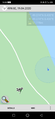
| Sun 19 Apr 2020 in 49,8: 49.2742415, 8.4296467 geohashing.info google osm bing/os kml crox |
Location
In a wilderness on the (pen)insula Flötzgrün near Mechtersheim.
Participants
Plans
So close to home, sunday, sunny weather, spring. What else would it need to go to this hash? I decided to wlak by foot.
Expedition
I started from home t10:45. I walked through the town for half an hour, but then I reached the fields. Short time later I reached the rhine dike and some minutes later I crossed the dike and walked on the dam that connects the peninsula Flötzgrün with the mainland.
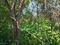
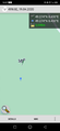
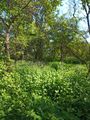
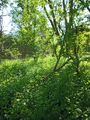
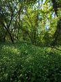
As I had to cross this dam twice, I couldn't reach a tron achievement. The island is covered wirth an alluvial forest and it was wonderful to walk there. There were a fantastillion birds singing. Half an hour later I left the mainpath and switched left to a smaller path. Soon I reached a lawn. According to Google there should be a path on the other side of the lawn, but there was just wilderness. I still had to go 70 m and I was up to call it a failure. But then I saw the water just next to the lawn and a walkable shore next to it. So I climbed down a small bank and followed the water for some meters. I came down to 35m. It was still just wilderness ebtween me and the hash, but it doesn't seem as dense as from the lawn-side. So I climbed the bank again and fought myself through some stinging-nettles. Thanks to good shoes and a dense trouser (which Ioffended me earlier for beeing to warm) I could cross the copse, althoug slowly. After some minutes I had a success. A tree stand just at the right point. Just some pictures, than I returned. As I could use my own path, the way back was much faster.
The rest of the way was rather uneventfull (except for an icecream at the gs station). After 3 hours I came back home.
Tracklog
Photos

Everything is going to be alright.
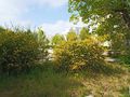
blossom (broom this time)
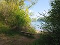
the water (oxbow)
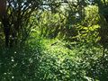
google says there is a path
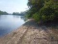
along the shore
still 35 m to go
doesn't look much better, but was manageable
proof
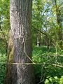
hashtree (west)
south
east
and north

happy hasher
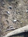
mussels (at the shore on my way back)


Achievements
DODO earned the Land geohash achievement
|
DODO earned the Walk geohash Achievement
|