Difference between revisions of "2020-05-08 -37 145"
Felix Dance (talk | contribs) ([live picture]Hash beers! [https://openstreetmap.org/?lat=-37.88454840&lon=145.07243160&zoom=16&layers=B000FTF @-37.8845,145.0724]) |
m |
||
| (9 intermediate revisions by 3 users not shown) | |||
| Line 1: | Line 1: | ||
| − | + | [[Image:{{{image|2020-05-08_-37_145_Felix Dance_1588932715058.jpg}}}|thumb|left]] | |
| − | + | {{meetup graticule | |
| − | [[Image:{{{image| | ||
| − | |||
| − | |||
| − | |||
| − | |||
| − | |||
| − | |||
| lat=-37 | | lat=-37 | ||
| lon=145 | | lon=145 | ||
| date=2020-05-08 | | date=2020-05-08 | ||
| − | }} | + | }} |
| + | |||
__NOTOC__ | __NOTOC__ | ||
| + | |||
== Location == | == Location == | ||
| − | + | On a suburban rail trail - the extension of the Alamein Line - in Glen Iris. | |
== Participants == | == Participants == | ||
| − | + | *[[User:Felix Dance|Felix Dance]] | |
| − | + | *[[User:Lachie|Lachie]] | |
| + | *[[User:LauraG|LauraG]] | ||
| − | == | + | == Expedition == |
| − | + | Friday night is a good night for a hash because you never know where the evening will go and if it's an epic disaster you don't have worry about being late for work the next day. | |
| + | |||
| + | As it happened, this was not an epic disaster, just a very satisfying hash. [[User:Lachie|Lachie]] came over to my house in Kensington and we proceeded on our respective bicycles (his a single-speed mine a geared road bike since my fixy had a flat) down Moonee Ponds Creek, along the Docklands and up the Yarra River towards Gardiners Creek bike trail. The full moon over the city illuminated our path and the quiet, quarantined streets provided us with a great calm. | ||
| + | |||
| + | Here we met up with Lachie's sister, Laura, who rode with us along Gardiners Creek, past her house near the hash and then onto the old Alamein Line extension suburban rail trail. It wasn't long before we'd arrived at the hash point so we ditched our bikes and did our little hash dance to get to the exact point (all staying outside 1.5m from one another of course). | ||
| − | + | Having hashed, we sat down to drink the beers we'd brought with us. We talked about our lives' greatest regrets, which were all geohash-related, naturally. When it got cold we got up and rode home, stopping by the new level crossing removal bridge over Toorak Rd near Laura's place to see it in action as the trains crossed over it. | |
| − | |||
| − | + | Lachie and I rode the rest of the way home along the same route, getting back a bit after 10pm. | |
| − | |||
== Photos == | == Photos == | ||
| − | |||
| − | |||
| − | |||
<gallery perrow="5"> | <gallery perrow="5"> | ||
| Line 40: | Line 35: | ||
Image:2020-05-08_-37_145_Felix Dance_1588936125857.jpg|Hash beers! [https://openstreetmap.org/?lat=-37.88454840&lon=145.07243160&zoom=16&layers=B000FTF @-37.8845,145.0724] | Image:2020-05-08_-37_145_Felix Dance_1588936125857.jpg|Hash beers! [https://openstreetmap.org/?lat=-37.88454840&lon=145.07243160&zoom=16&layers=B000FTF @-37.8845,145.0724] | ||
| + | |||
| + | Image:Geohash 2020-05-08 -37 145 City.jpg|Full moon over city | ||
| + | Image:Geohash 2020-05-08 -37 145 Felix.jpg|Me riding to the hash | ||
| + | Image:Geohash 2020-05-08 -37 145 Bridge.jpg|Level crossing removal bridge | ||
| + | Image:Screenshot_20200511-092952.jpg|strava route | ||
| + | |||
</gallery> | </gallery> | ||
== Achievements == | == Achievements == | ||
| − | |||
| − | |||
| − | |||
| − | |||
| − | |||
| − | |||
| − | |||
| − | |||
| − | + | {{bicycle geohash | |
| − | |||
| − | |||
| − | |||
| − | + | | latitude = -37 | |
| + | | longitude = 145 | ||
| + | | date = 2020-05-08 | ||
| + | | name = Felix, Lachie and Laura | ||
| + | | distance = 46.3 kms | ||
| + | | bothways = true | ||
| + | | image = 2020-05-08_-37_145_Felix Dance_1588932715058.jpg | ||
| + | }} | ||
| − | |||
[[Category:Expeditions]] | [[Category:Expeditions]] | ||
| − | |||
[[Category:Expeditions with photos]] | [[Category:Expeditions with photos]] | ||
| − | |||
| − | |||
| − | |||
| − | |||
| − | |||
[[Category:Coordinates reached]] | [[Category:Coordinates reached]] | ||
| − | + | {{location|AU|VIC|SN}} | |
| − | |||
| − | |||
| − | |||
| − | |||
| − | |||
| − | |||
| − | |||
| − | |||
| − | |||
| − | |||
| − | |||
| − | |||
| − | |||
| − | |||
| − | |||
| − | |||
| − | |||
Latest revision as of 10:31, 25 October 2021

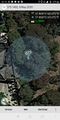
| Fri 8 May 2020 in -37,145: -37.8844914, 145.0722988 geohashing.info google osm bing/os kml crox |
Location
On a suburban rail trail - the extension of the Alamein Line - in Glen Iris.
Participants
Expedition
Friday night is a good night for a hash because you never know where the evening will go and if it's an epic disaster you don't have worry about being late for work the next day.
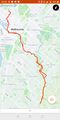
As it happened, this was not an epic disaster, just a very satisfying hash. Lachie came over to my house in Kensington and we proceeded on our respective bicycles (his a single-speed mine a geared road bike since my fixy had a flat) down Moonee Ponds Creek, along the Docklands and up the Yarra River towards Gardiners Creek bike trail. The full moon over the city illuminated our path and the quiet, quarantined streets provided us with a great calm.
Here we met up with Lachie's sister, Laura, who rode with us along Gardiners Creek, past her house near the hash and then onto the old Alamein Line extension suburban rail trail. It wasn't long before we'd arrived at the hash point so we ditched our bikes and did our little hash dance to get to the exact point (all staying outside 1.5m from one another of course).
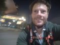
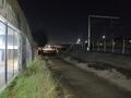
Having hashed, we sat down to drink the beers we'd brought with us. We talked about our lives' greatest regrets, which were all geohash-related, naturally. When it got cold we got up and rode home, stopping by the new level crossing removal bridge over Toorak Rd near Laura's place to see it in action as the trains crossed over it.
Lachie and I rode the rest of the way home along the same route, getting back a bit after 10pm.
Photos
Geohash success!
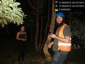
Hash buddies! @-37.8845,145.0723
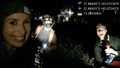
Hash beers! @-37.8845,145.0724
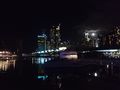
Full moon over city
Me riding to the hash
Level crossing removal bridge
strava route


Achievements
Felix, Lachie and Laura earned the Bicycle geohash achievement
|