Difference between revisions of "2020-07-31 48 7"
From Geohashing
(Created page with "{{meetup graticule | lat=48 | lon=7 | date=2020-07-31 }} == Location == In a forest near Neunkirch (Friesenheim). == Participants == Baarde == Plans...") |
m |
||
| (10 intermediate revisions by the same user not shown) | |||
| Line 4: | Line 4: | ||
| date=2020-07-31 | | date=2020-07-31 | ||
}} | }} | ||
| − | |||
== Location == | == Location == | ||
| − | In a forest near Neunkirch (Friesenheim). | + | In a forest near Neunkirch ([[wikipedia:Friesenheim, Bas-Rhin|Friesenheim]]). |
== Participants == | == Participants == | ||
| − | [[User:Baarde|Baarde]] | + | * [[User:Baarde|Baarde]] |
== Plans == | == Plans == | ||
| − | The coordinates are located near the northern branch of the | + | The coordinates are located near the northern branch of the Rhône-Rhine Canal. Ideal for a bike ride on the EuroVelo 15. |
== Expedition == | == Expedition == | ||
| + | I took the EuroVelo 15 at Marckolsheim. From there it was a straight route along the Rhone-Rhine Canal until Neunkirch. The coordinate was located in a small forest near the hamlet, in the middle of a half-buried path. I arrived there at 13:10. Easy! | ||
| − | + | In order to use a different route on the way back, I continued a little bit on the EV15, crossed the Rhine with the ferry at Rhinau and took a small detour across Germany before crossing back on the Sasbach-Marckolsheim bridge. | |
| + | == Photos == | ||
| + | <gallery> | ||
| + | Image:2020-07-31_48_7_01.jpg | Taking the EV15 at Marckolsheim | ||
| + | Image:2020-07-31_48_7_02.jpg | Exiting the EV15 at Neunkirch | ||
| + | Image:2020-07-31_48_7_03.jpg | Stupid grin | ||
| + | Image:2020-07-31_48_7_04.png | Coordinates reached | ||
| + | </gallery> | ||
== Achievements == | == Achievements == | ||
| − | {{#vardefine:ribbonwidth| | + | {{#vardefine:ribbonwidth|100%}} |
{{land geohash | {{land geohash | ||
| latitude = 48 | | latitude = 48 | ||
| longitude = 7 | | longitude = 7 | ||
| date = 2020-07-31 | | date = 2020-07-31 | ||
| − | | name = Baarde | + | | name = [[User:Baarde|Baarde]] |
}} | }} | ||
{{bicycle geohash | {{bicycle geohash | ||
| Line 32: | Line 39: | ||
| longitude = 7 | | longitude = 7 | ||
| date = 2020-07-31 | | date = 2020-07-31 | ||
| − | | name = Baarde | + | | name = [[User:Baarde|Baarde]] |
| − | | distance = | + | | distance = 82 km |
| bothways = true | | bothways = true | ||
| − | |||
| − | |||
| − | |||
| − | |||
| − | |||
| − | |||
| − | |||
| − | |||
}} | }} | ||
| + | __NOTOC__ | ||
[[Category:Expeditions]] | [[Category:Expeditions]] | ||
| + | [[Category:Expeditions with photos]] | ||
[[Category:Coordinates reached]] | [[Category:Coordinates reached]] | ||
{{location|FR|67}} | {{location|FR|67}} | ||
Latest revision as of 22:00, 27 March 2023
| Fri 31 Jul 2020 in 48,7: 48.3069398, 7.6326234 geohashing.info google osm bing/os kml crox |
Location
In a forest near Neunkirch (Friesenheim).
Participants
Plans
The coordinates are located near the northern branch of the Rhône-Rhine Canal. Ideal for a bike ride on the EuroVelo 15.
Expedition
I took the EuroVelo 15 at Marckolsheim. From there it was a straight route along the Rhone-Rhine Canal until Neunkirch. The coordinate was located in a small forest near the hamlet, in the middle of a half-buried path. I arrived there at 13:10. Easy!
In order to use a different route on the way back, I continued a little bit on the EV15, crossed the Rhine with the ferry at Rhinau and took a small detour across Germany before crossing back on the Sasbach-Marckolsheim bridge.
Photos
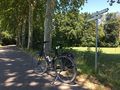
Taking the EV15 at Marckolsheim
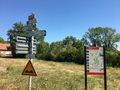
Exiting the EV15 at Neunkirch
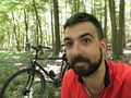
Stupid grin
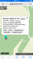
Coordinates reached


Achievements
Baarde earned the Land geohash achievement
|
Baarde earned the Bicycle geohash achievement
|